
Prüm (river)
.png)


The Prüm is an 85 km long orographically left tributary of the Sauer in the Eifel . It flows in the district of Vulkaneifel and Eifelkreis Bitburg-Prüm in Rhineland-Palatinate .
The river is known for its rapids between Prümzurlay and Irrel (Prümer and Irrel waterfalls ), where kayak competitions take place regularly .
geography
course
The Prüm rises in the Vulkaneifel district at the north-eastern end of the Schneifel ridge. Its source is between Ormont and Reuth at 650 m above sea level. NHN in the Arenberg Forest.
Initially, the Prüm runs north to west past the Ormont district of Neuenstein . Shortly afterwards it reaches the Eifelkreis Bitburg-Prüm and flows through Neuendorf and Olzheim . The river then runs through the city center of Prüm and passes Niederprüm . It then runs through Watzerath , where the Mehlenbach joins, Pittenbach and Pronsfeld , where the Alfbach joins . Up to there the river runs mainly south-south-west.
From then on the Prüm turns south and runs through Lünebach . Then the Prüm flows between Merlscheid and Kinzenburg and reaches Waxweiler . From now on it runs south-southeast. The river Niederpierscheid , Mauel , Echtershausen and Hamm , where it forms several river loops. It then flows through the Bitburg reservoir (39.3 ha), on whose eastern bank Biersdorf am See lies.
After passing Wiersdorf, the Prüm flows through Hermesdorf , turns to the south-southwest, Wißmannsdorf , Brecht , Oberweis and Bettingen . From then on it flows southwards and passes Wettlingen and Peffingen . From the Holsthum , which then flows through , where the Enz joins, the river turns to the south-southeast and flows through Prümzurlay and Irrel , where the Nims flows, and passes Menningen .
A little further south, the Prüm flows into Minden as the largest tributary into the Moselle tributary Sauer ; the mouth is about the same longitude as the source and thus almost south of the source.
Catchment area and tributaries
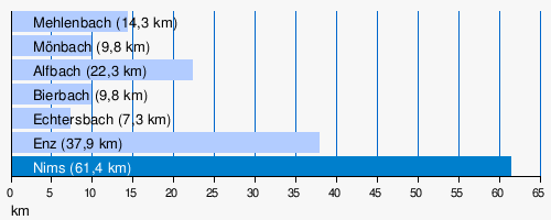
The catchment area of the Prüm is 888.758 km². Its tributaries include: The largest tributaries of the Prüm are; (l = left side (dark blue), r = right side; light blue):
- Mehlenbach (r), 14.3 km, before Watzerath
- Mönbach (r), 9.8 km, to Watzerath
- Alfbach (r), 22.3 km, near Pronsfeld
- Bierbach (r), 9.8 km, to Pronsfeld
- Echtersbach (r), 7.3 km, before Brecht
- Enz (r), 37.9 km, in Holsthum
- Nims (l), 61.4 km, near Irrel
Web links
- Map / aerial photo of the course of the Prüm
- Current water level at the Prümzurlay gauge (RLP water management authority)
Individual evidence
- ↑ a b Map service of the landscape information system of the Rhineland-Palatinate nature conservation administration (LANIS map) ( notes ) (DTK 1: 5,000 color)
- ↑ a b c GeoExplorer of the Rhineland-Palatinate Water Management Authority ( information )
- ↑ Level data from the LfU Rhineland-Palatinate
- ↑ Added level data from Prümzurlay on the Prüm and Alsdorf-Oberecken on the Nims flowing in below, increased by the remaining catchment area (51.2 km²) with a (low estimated) Mq of 10 l / s km²