
Wiersdorf (Eifel)
| coat of arms | Germany map | |
|---|---|---|

|
Coordinates: 50 ° 0 ' N , 6 ° 27' E |
|
| Basic data | ||
| State : | Rhineland-Palatinate | |
| County : | Eifel district Bitburg-Prüm | |
| Association municipality : | Bitburger Land | |
| Height : | 290 m above sea level NHN | |
| Area : | 4.06 km 2 | |
| Residents: | 276 (Dec. 31, 2019) | |
| Population density : | 68 inhabitants per km 2 | |
| Postal code : | 54636 | |
| Area code : | 06569 | |
| License plate : | BIT, PRÜ | |
| Community key : | 07 2 32 134 | |
| Association administration address: | Hubert-Prim-Strasse 7 54634 Bitburg |
|
| Website : | ||
| Local Mayor : | Stefan Theis | |
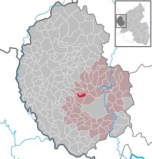
| Location of the local community of Wiersdorf in the Eifel district of Bitburg-Prüm | ||
  |
||


Wiersdorf is a municipality in the Eifelkreis Bitburg-Prüm in Rhineland-Palatinate . It belongs to the Verbandsgemeinde Bitburger Land .
geography
Wiersdorf is located in the southwest Eifel , about 10 km northwest of the district town of Bitburg. The municipal area extends in a hollow that slopes down towards the Prüm and is occupied in the western area by the Bitburg reservoir . Of the 4.06 km² area, 62.3% is agricultural area, 21% is forested (as of 2017). The residential areas Im Pfaffendell and Rittersdell also belong to Wiersdorf .
history
Like much of the Bitburger Land, the Wiersdorf municipality was already settled in Roman times. The Romans built an extensive villa complex in Wiersdorf, which was built in six construction phases between the 1st and 4th centuries. Row graves in the “Bergkessel” area testify to the Franconian period . The first written mention of the place as "Veresdorph" took place in 893 in the Prümer Urbar . Until the French period at the end of the 18th century, Wiersdorf belonged together with the neighboring town of Biersdorf to the Hamm dominion in the Duchy of Luxembourg .
Since 1970, Wiersdorf has been part of the Bitburg-Land Association, which was then newly formed as part of the Rhineland-Palatinate municipal reform, and since July 1, 2014, the Bitburger Land Association .
politics
The municipal council in Wiersdorf consists of six council members who were elected by a majority vote in the local elections on May 26, 2019 , and the honorary local mayor as chairman.
Attractions
The branch church of St. Markus dates from 1746 and contains a choir built after 1587 and a valuable wooden altarpiece from 1740. The outer walls are adorned with sandstone reliefs from 1600 that show the seven footfalls . In 1979/1980 the church was extensively restored. The measures included a. a restoration of the space from the turn of the century.
Another sacred building is the "Einsiedelei" chapel on a meadow slope west of the Prüm . The building, which is now a cultural monument , was built in 1923 by Jakob Leisen. A Lourdes grotto was built below the chapel in 1927 , a Marian column made of red sandstone blocks in 1929/30 and a 14-station Way of the Cross by the sculptor Franz-Josef Leisen in 1931 . Due to its quiet location, among other things, the chapel is often used for processions from the neighboring parishes .
See also: List of cultural monuments in Wiersdorf
economy
From an economic point of view, Wiersdorf is a distinctly agricultural community. There are 10 full-time businesses in this sector. The products of the orchards spread across the municipality are processed into Eifeler fruit schnapps in the distilleries . A second economic pillar is tourism , which is favored by the nearby Bitburg reservoir . Most of the workers are employed in Bitburg, the Trier area or in Luxembourg .
Web links
- Local community Wiersdorf on the website of the Verbandsgemeinde Bitburger Land
- To search for cultural assets of the local community Wiersdorf (Eifel) in the database of cultural assets in the Trier region .
Individual evidence
- ↑ State Statistical Office of Rhineland-Palatinate - population status 2019, districts, communities, association communities ( help on this ).
- ↑ State Statistical Office Rhineland-Palatinate: Regional data.
- ↑ State Statistical Office Rhineland-Palatinate (ed.): Official directory of the municipalities and parts of the municipality. Status: January 2019 [ Version 2020 is available. ] . S. 109 (PDF; 3 MB).
- ^ The Regional Returning Officer Rhineland-Palatinate: Local elections 2019, city and municipal council elections
Bath | Balesfeld | Baustert | Bettingen | Bickendorf | Biersdorf am See | Birtlingen | Brecht | Brimingen | Burbach | Dahlem | Dockendorf | Dudeldorf | Echtershausen | Ehlenz | Enzen | Esslingen | Etteldorf | Feilsdorf | Flowem | Gindorf | Gondorf | Gransdorf | Halsdorf | Hamm | Heilenbach | Hütterscheid | Hüttingen an der Kyll | Idenheim | Idesheim | Ingendorf | Kyllburg | Kyllburgweiler | Ließem | Malberg | Malberg soft | Meckel | Messerich | Metterich | Mülbach | Nattenheim | Neidenbach | Neuheilenbach | Niederstedem | Niederweiler | Oberkail | Oberstedem | Oberweiler | Oberweis | Olsdorf | Orsfeld | Pickleneem | Rittersdorf | Röhl | Saint Thomas | Sharply cheap | Schleid | Seffern | Seffer soft | Field of being | Steinborn | Stockem | Sülm | Trimport | Usch | Wettlingen | Wiersdorf | Wilsecker | Wissmannsdorf | Wolsfeld | Zendscheid