
Sharply cheap
| coat of arms | Germany map | |
|---|---|---|

|
Coordinates: 49 ° 56 ' N , 6 ° 33' E |
|
| Basic data | ||
| State : | Rhineland-Palatinate | |
| County : | Eifel district Bitburg-Prüm | |
| Association municipality : | Bitburger Land | |
| Height : | 360 m above sea level NHN | |
| Area : | 4.82 km 2 | |
| Residents: | 87 (Dec 31, 2019) | |
| Population density : | 18 inhabitants per km 2 | |
| Postal code : | 54636 | |
| Area code : | 06561 | |
| License plate : | BIT, PRÜ | |
| Community key : | 07 2 32 115 | |
| Association administration address: | Hubert-Prim-Strasse 7 54634 Bitburg |
|
| Website : | ||
| Mayoress : | Anna Stoffel | |
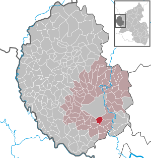
| Location of the local community Scharfbillig in the Eifelkreis Bitburg-Prüm | ||
  |
||

Scharfbillig is a municipality in the Eifelkreis Bitburg-Prüm in Rhineland-Palatinate . It belongs to the Verbandsgemeinde Bitburger Land .
geography
The community is located in the South West Eifel , 5 km south of the district town of Bitburg in the so-called "Bitburger Gutland ". Of the 4.82 km² municipal area, 68% are used for agriculture, with 19% being a comparatively small proportion of forest (as of 2017). Bitburg Airport is in the immediate vicinity .
history
The first documentary mention as "charpilge" took place in 1273. Numerous sites from Roman times point to a much earlier settlement of the municipality, including the settlement in the area "On birch hedges" from the 3rd and 4th century. Several barrows in the area "Vor der Hardt" testify to the Romans . As a separate rule, Scharfbillig was previously part of the Bitburg district in the Duchy of Luxembourg .
politics
Municipal council
The local council in Scharfbillig consists of six council members, who were elected by a majority vote in the local elections on May 26, 2019 , and the honorary local mayor as chairman.
coat of arms
The municipal coat of arms is based on the former coat of arms of the von Scharfbillig family in silver and with two blue diagonal bars. The three church bells with bells on the church portal of the branch church “St. Lukas ”.

Attractions
The Catholic branch church “St. Lukas ”was built in 1818. Other sights are the "Himmeroder Hof", an agricultural courtyard building at Kirchstrasse 14. The building was the western farm of the Cistercian Abbey of Himmerod on the border with the Benedictine monastery and has been in use since 1273.
Public facilities
The community is the location of a volunteer fire brigade with around 10 members, which is the only association in Scharfbillig. Ecclesiastically the place belongs to the parish of Sülm. The former school is located on the outskirts and is now used as a village community center.
Web links
- Local community Scharfbillig on the website of the Verbandsgemeinde Bitburger Land
- To search for cultural assets of the local community Scharfbillig in the database of cultural assets in the Trier region .
Individual evidence
- ↑ State Statistical Office of Rhineland-Palatinate - population status 2019, districts, communities, association communities ( help on this ).
- ↑ State Statistical Office Rhineland-Palatinate: Regional data.
- ^ The Regional Returning Officer Rhineland-Palatinate: Local elections 2019, city and municipal council elections
Bath | Balesfeld | Baustert | Bettingen | Bickendorf | Biersdorf am See | Birtlingen | Brecht | Brimingen | Burbach | Dahlem | Dockendorf | Dudeldorf | Echtershausen | Ehlenz | Enzen | Esslingen | Etteldorf | Feilsdorf | Flowem | Gindorf | Gondorf | Gransdorf | Halsdorf | Hamm | Heilenbach | Hütterscheid | Hüttingen an der Kyll | Idenheim | Idesheim | Ingendorf | Kyllburg | Kyllburgweiler | Ließem | Malberg | Malberg soft | Meckel | Messerich | Metterich | Mülbach | Nattenheim | Neidenbach | Neuheilenbach | Niederstedem | Niederweiler | Oberkail | Oberstedem | Oberweiler | Oberweis | Olsdorf | Orsfeld | Pickleneem | Rittersdorf | Röhl | Saint Thomas | Sharply cheap | Schleid | Seffern | Seffer soft | Field of being | Steinborn | Stockem | Sülm | Trimport | Usch | Wettlingen | Wiersdorf | Wilsecker | Wissmannsdorf | Wolsfeld | Zendscheid