
Stockem (Eifelkreis Bitburg-Prüm)
| coat of arms | Germany map | |
|---|---|---|

|
Coordinates: 49 ° 56 ' N , 6 ° 23' E |
|
| Basic data | ||
| State : | Rhineland-Palatinate | |
| County : | Eifel district Bitburg-Prüm | |
| Association municipality : | Bitburger Land | |
| Height : | 310 m above sea level NHN | |
| Area : | 3.97 km 2 | |
| Residents: | 85 (Dec. 31, 2019) | |
| Population density : | 21 inhabitants per km 2 | |
| Postal code : | 54646 | |
| Area code : | 06527 | |
| License plate : | BIT, PRÜ | |
| Community key : | 07 2 32 124 | |
| Association administration address: | Hubert-Prim-Strasse 7 54634 Bitburg |
|
| Website : | ||
| Local Mayor : | Markus Gaspers | |
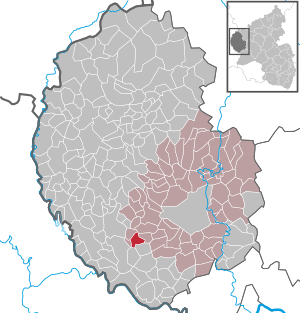
| Location of the local community Stockem (Eifelkreis Bitburg-Prüm) in the Eifelkreis Bitburg-Prüm | ||
  |
||

Stockem is a municipality in the Eifelkreis Bitburg-Prüm in Rhineland-Palatinate . It belongs to the Verbandsgemeinde Bitburger Land .
geography
The community is located about ten kilometers southwest of the district town of Bitburg on the plateau between Prüm and Enz . The state border with Luxembourg runs eleven kilometers southwest of the town. The federal highway 50 , about five kilometers north of Stockem, leads u. a. to Bitburg and Luxembourg. 66% of the 3.97 km² municipal area is agricultural area , a smaller proportion of 25% consists of forest (as of 2017). The Lindenhof residential area also belongs to Stockem .
history
The first documentary mention as "Stochheim" comes from the year 1132. The name ending at that time "-heim" suggests that the place originated at the time of the Franconian conquest .
The place belonged to the Duchy of Luxembourg until the end of the 18th century and was divided into the lords of Bettingen and Neuerburg . In 1794 French revolutionary troops occupied the Austrian Netherlands , to which the Duchy of Luxembourg belonged, and annexed it in October 1795 . From 1795 to 1814 Stockem belonged to the canton of Neuerburg in the department of forests . After the region was taken over by the Kingdom of Prussia (1815), Baustert became the administrative seat of the mayor's office of the same name in the Bitburg district , which became part of the Baustert mayor's office in 1856 and was later incorporated into the Oberweis office.
Since the early 19th century the population has increased slowly but continuously: from 84 inhabitants (1828) to 98 inhabitants with 10 houses (1848) and 120 (1986), in 1953 142 inhabitants were already reached. The population has been falling steadily since the middle of the 20th century, today only 85 residents have their main residence in the local community of Stockem.
Municipal council
The municipal council in Stockem consists of six council members, who were elected by a majority vote in the local elections on May 26, 2019 , and the honorary local mayor as chairman.
Attractions
The former parish church of St. Hubertus is a two-aisled building with a late Gothic star vault from around 1500. The cultural monument includes u. a. an early Gothic east tower from 1220 and a wood-carved high altar from the 18th century. Also worth seeing are the “Neises Court Chapel” from 1912 and the “Hofkapelle im Ort” from the beginning of the 20th century, also both cultural monuments.
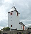
Branch church "St. Hubertus "

Crossroads [17] 68

68.jpg)
See also: List of cultural monuments in Stockem
Web links
- Local community Stockem on the website of the Verbandsgemeinde Bitburger Land
- To search for cultural assets of the Stockem community in the database of cultural assets in the Trier region .
Individual evidence
- ↑ State Statistical Office of Rhineland-Palatinate - population status 2019, districts, communities, association communities ( help on this ).
- ↑ State Statistical Office Rhineland-Palatinate: Regional data.
- ↑ State Statistical Office Rhineland-Palatinate (ed.): Official directory of the municipalities and parts of the municipality. Status: January 2019 [ Version 2020 is available. ] . S. 109 (PDF; 3 MB).
- ^ The Regional Returning Officer Rhineland-Palatinate: Local elections 2019, city and municipal council elections
Bath | Balesfeld | Baustert | Bettingen | Bickendorf | Biersdorf am See | Birtlingen | Brecht | Brimingen | Burbach | Dahlem | Dockendorf | Dudeldorf | Echtershausen | Ehlenz | Enzen | Esslingen | Etteldorf | Feilsdorf | Flowem | Gindorf | Gondorf | Gransdorf | Halsdorf | Hamm | Heilenbach | Hütterscheid | Hüttingen an der Kyll | Idenheim | Idesheim | Ingendorf | Kyllburg | Kyllburgweiler | Ließem | Malberg | Malberg soft | Meckel | Messerich | Metterich | Mülbach | Nattenheim | Neidenbach | Neuheilenbach | Niederstedem | Niederweiler | Oberkail | Oberstedem | Oberweiler | Oberweis | Olsdorf | Orsfeld | Pickleneem | Rittersdorf | Röhl | Saint Thomas | Sharply cheap | Schleid | Seffern | Seffer soft | Field of being | Steinborn | Stockem | Sülm | Trimport | Usch | Wettlingen | Wiersdorf | Wilsecker | Wissmannsdorf | Wolsfeld | Zendscheid