
Metterich
| coat of arms | Germany map | |
|---|---|---|

|
Coordinates: 49 ° 59 ' N , 6 ° 35' E |
|
| Basic data | ||
| State : | Rhineland-Palatinate | |
| County : | Eifel district Bitburg-Prüm | |
| Association municipality : | Bitburger Land | |
| Height : | 310 m above sea level NHN | |
| Area : | 5.6 km 2 | |
| Residents: | 542 (Dec. 31, 2019) | |
| Population density : | 97 inhabitants per km 2 | |
| Postal code : | 54634 | |
| Area code : | 06565 | |
| License plate : | BIT, PRÜ | |
| Community key : | 07 2 32 081 | |
| Association administration address: | Hubert-Prim-Strasse 7 54634 Bitburg |
|
| Website : | ||
| Local Mayor : | Norbert Otten | |
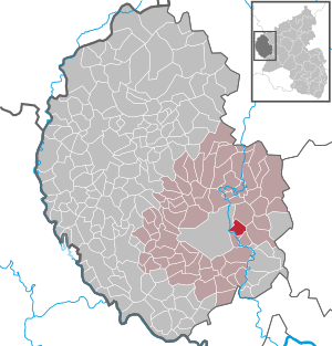
| Location of the local community Metterich in the Eifelkreis Bitburg-Prüm | ||
  |
||

;_Panoramablick_a.jpg)

Metterich is a municipality in the Eifelkreis Bitburg-Prüm in Rhineland-Palatinate . It belongs to the Verbandsgemeinde Bitburger Land .
geography
The community is located in the south-west Eifel about five kilometers northeast of the district town of Bitburg. To the west of the village runs the Kyll , on whose plateau the municipality extends.
The community also includes the residential areas Berghaus, Bernhardshof, Forellenhof, Kuhberg, Mettericher Mühle, Waldhof.
history
Finds of a fire burial ground and several settlement sites bear witness to the early Roman settlement of the municipality . In the area “In der Eich” graves from the Frankish period were found. Count Sigard left his property in the place called "Metriche" at that time in 844 to the Prüm Abbey . The Trier Abbey of St. Maximin owned goods in Metterich from 1200, such as a mill that was taxable from 1729–1740 of the Bitburg rule. In 1794 the place was divided territorially between the Luxembourg provost Bitburg and the rule Dudeldorf. In 1795 it became the seat of Mairie Metterich, who in 1816 passed into the Prussian mayor's office of the same name in the Bitburg district ( Trier district ). The latter went to the mayor's office in Dudeldorf in 1856 , from 1927 to the Dudeldorf office, which in 1970 was merged with four other offices as part of the functional and territorial reform of the Rhineland-Palatinate to form the Verbandsgemeinde Bitburg-Land .
Metterich has been a member of the Bitburger Land community since July 1, 2014 .
In 1848 there were 320 inhabitants in 42 houses in Metterich, with 17 people living in the local mill. In 1895 the place already comprised 54 houses and 390 inhabitants. In 1939 the population had decreased to 382 people, but after several fluctuations it has increased again to 471 inhabitants (2006).
- Population development
The development of the population of Metterich, the values from 1871 to 1987 are based on censuses:
|
|
religion
87% of the residents of Metterich are Catholic, only 2% Protestant. The Catholic parish of St. Eucharius in Metterich belongs to the parish community of Speicher in the Bitburg dean's office of the Trier diocese . The few Protestants are assigned to the Evangelical Church Community of Bitburg in the Evangelical Church in the Rhineland .
politics
Municipal council
The municipal council in Metterich consists of twelve council members, who were elected by a majority vote in the local elections on May 26, 2019 , and the honorary local mayor as chairman. Until 2014, the council had eight councilors.
coat of arms
|
|
|
| Justification for the coat of arms: The colors silver and blue are an indication of the former affiliation to the Duchy of Luxembourg . For many centuries the landlord was the Imperial Abbey of St. Maximin , its symbol is the double-headed eagle. The von Lontzen family was also the landlord, as indicated by the blue bar of thorns. The three golden nailed crosses represent the affiliation to the Bitburg provost . |
Culture and sights
;_katholische_Pfarrkirche_St._Eucharius_a.jpg)
- Catholic Parish Church of St. Eucharius, a single-nave hall church from the 18th century
- Catholic rectory from 1719
- South portal of the Metterich railway tunnel from 1871
- Old wayside crosses are distributed over the municipality ; including the Erdorfer Cross around 1620. ⊙
- Several old farms and houses in the village
See also: List of cultural monuments in Metterich
Green spaces and recreation
- Hiking routes in and around Metterich
Regular events
- Annual fair or parish fair
- Traditional rattling or rattling on Good Friday and Holy Saturday
- Hut burning on the first weekend after Ash Wednesday (so-called Scheef Sunday)
Economy and Infrastructure
Of the 5.6 km² municipal area, a comparatively large 70% is used for agriculture, only 17% are forest. The federal road 50 (Bitburg – Wittlich) leads directly past Metterich . The next bathing junction on the Bundesautobahn 60 is about 5 km away.
literature
- Ernst Wackenroder (arr.): The art monuments of the Bitburg district (= Paul Clemen [Hrsg.]: The art monuments of the Rhine province . Volume 12 / I ). Trier 1983, ISBN 3-88915-006-3 , p. 182–185 (315 p., With 12 plates and 227 illustrations in the text. Reprinted by the Schwann edition, Düsseldorf 1927).
- Michael Berens: Parish Church of St. Eucharius in Metterich . In: Geschichtlicher Arbeitskreis Bitburger Land (Hrsg.): The churches and chapels of the Bitburger Land . S. 69 ( online [PDF; accessed April 5, 2018]).
Web links
- Local community Metterich on the website of the Verbandsgemeinde Bitburger Land
- To search for cultural assets of the local community Metterich in the database of cultural assets in the Trier region .
Individual evidence
- ↑ State Statistical Office of Rhineland-Palatinate - population status 2019, districts, communities, association communities ( help on this ).
- ↑ State Statistical Office Rhineland-Palatinate (ed.): Official directory of the municipalities and parts of the municipality. Status: January 2019 [ Version 2020 is available. ] . S. 107 (PDF; 3 MB).
- ↑ State Statistical Office Rhineland-Palatinate: Regional data.
- ↑ 2011 census
- ^ The Regional Returning Officer Rhineland-Palatinate: Local elections 2019, city and municipal council elections
- ^ Metterich's coat of arms description on the website of the Bitburger Land association
- ↑ Circular hike bath - Metterich - bath. Retrieved April 24, 2018 .
- ↑ Hüttenbrennen in the Eifel. Retrieved May 1, 2016 .
- ↑ Hut Sunday in the Eifel. Retrieved August 10, 2017 .
Bath | Balesfeld | Baustert | Bettingen | Bickendorf | Biersdorf am See | Birtlingen | Brecht | Brimingen | Burbach | Dahlem | Dockendorf | Dudeldorf | Echtershausen | Ehlenz | Enzen | Esslingen | Etteldorf | Feilsdorf | Flowem | Gindorf | Gondorf | Gransdorf | Halsdorf | Hamm | Heilenbach | Hütterscheid | Hüttingen an der Kyll | Idenheim | Idesheim | Ingendorf | Kyllburg | Kyllburgweiler | Ließem | Malberg | Malberg soft | Meckel | Messerich | Metterich | Mülbach | Nattenheim | Neidenbach | Neuheilenbach | Niederstedem | Niederweiler | Oberkail | Oberstedem | Oberweiler | Oberweis | Olsdorf | Orsfeld | Pickleneem | Rittersdorf | Röhl | Saint Thomas | Sharply cheap | Schleid | Seffern | Seffer soft | Field of being | Steinborn | Stockem | Sülm | Trimport | Usch | Wettlingen | Wiersdorf | Wilsecker | Wissmannsdorf | Wolsfeld | Zendscheid