
Meckel
| coat of arms | Germany map | |
|---|---|---|

|
Coordinates: 49 ° 53 ' N , 6 ° 31' E |
|
| Basic data | ||
| State : | Rhineland-Palatinate | |
| County : | Eifel district Bitburg-Prüm | |
| Association municipality : | Bitburger Land | |
| Height : | 300 m above sea level NHN | |
| Area : | 10.8 km 2 | |
| Residents: | 388 (Dec. 31, 2019) | |
| Population density : | 36 inhabitants per km 2 | |
| Postal code : | 54636 | |
| Area code : | 06568 | |
| License plate : | BIT, PRÜ | |
| Community key : | 07 2 32 077 | |
| Association administration address: | Hubert-Prim-Strasse 7 54634 Bitburg |
|
| Website : | ||
| Local Mayor : | Johannes Junk | |
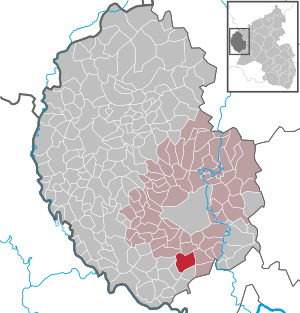
| Location of the local community of Meckel in the Eifelkreis Bitburg-Prüm | ||
  |
||

Meckel is a municipality in the Eifelkreis Bitburg-Prüm in Rhineland-Palatinate . It belongs to the Verbandsgemeinde Bitburger Land .
geography
Meckel is located in the southwest Eifel , about 10 km south of the center of the district town of Bitburg. The municipal area extends in a valley and is crossed by the federal highway 51 on the south-eastern edge . The altitude ranges from 300 m above sea level. NHN to 391 u m. NHN . The Nüßbach, a left tributary of the Nims, flows through the village . The Meilbrück residential area also belongs to Meckel .
history
Extensive remains from Roman times testify to the early settlement of the municipality . At that time, the Roman estate "Scheiwelsheck" and the temple district of Meilbrück stood on today's route from Meckel to Gilzem . The first written mention of the place probably took place between 711 and 814, when a certain Harduwinus assigned his estate to the Echternach monastery as "Meckeia cum ecclesia" . Until the French period at the end of the 18th century, Meckel belonged to the Luxembourg provost of Bitburg . In 1795, Meckel came to the canton of Bitburg in the French department of forests , later the village became the seat of Mairie Meckel, who passed into the mayor's office of the same name at the beginning of Prussian rule . In 1824 a personal union was formed from the mayorships of Meckel and Idenheim , which administrated the common area from Röhl . The mayor's office in Bitburg-Land became the successor to this personal union in 1860 and finally merged with four other offices in 1970 as part of the Rhineland-Palatinate functional and territorial reform in 1970 to form the Verbandsgemeinde Bitburg-Land . Since 2014, Meckel has belonged to the Bitburger Land association.
In 1991, Meckel was awarded a gold plaque in the competition Our village should be more beautiful .
- Population development
The development of the population of Meckel, the values from 1871 to 1987 are based on censuses:

|
|
Municipal council
The local council in Meckel consists of eight council members, who were elected in the local elections on May 26, 2019 in a majority vote, and the honorary local mayor as chairman.
coat of arms
|
|
|
| The reason for the coat of arms: The red lily cross is an indication of the long association with Echternach, while the five-pointed stars are borrowed from the old Bitburger provost seal. |


Attractions
There are some old farmhouses in particular south of the Nüßbach. The parish church of St. Bartholomew , built from 1896 to 1898 according to the plans of the cathedral builder Reinhold Wirtz, is also located there . The former parish church, now used as a cemetery chapel, is in the immediate vicinity. It is one of the late Gothic single-pillar rooms widespread in the West Eifel, which were built in the late 15th and early 16th centuries. There are some very old tombstones and crosses around the chapel .
Most of the development north of the Nüßbach is newer substance. This section of the village is determined by the inn and the old barn a little further away .
economy
Like many communities in the Eifel , Meckel is also characterized by agriculture . There are still some full-time and part-time farmers in this area. In contrast to other places in the area, Meckel is also the location of some industrial and service-sector companies. A village inn, a rest stop with a petrol station, a sawmill , a carpentry and a quarry offer several jobs on site. Nevertheless, most of the workers are employed in nearby Bitburg, in the Trier area or in Luxembourg .
Web links
- Local municipality of Meckel on the website of the Bitburger Land association
- To search for cultural assets of the local community of Meckel in the database of cultural assets in the Trier region .
Individual evidence
- ↑ State Statistical Office of Rhineland-Palatinate - population status 2019, districts, communities, association communities ( help on this ).
- ↑ State Statistical Office Rhineland-Palatinate (ed.): Official directory of the municipalities and parts of the municipality. Status: January 2019 [ Version 2020 is available. ] . S. 107 (PDF; 3 MB).
- ↑ State Statistical Office Rhineland-Palatinate: Regional data.
- ^ The Regional Returning Officer Rhineland-Palatinate: Local elections 2019, city and municipal council elections
- ↑ Declaration of the coat of arms. Retrieved July 5, 2016 .
- ↑ Entry on Saint Bartholomew (1) in the database of cultural assets in the Trier region ; accessed on September 22, 2015.
- ↑ Entry on Saint Bartholomew (2) in the database of cultural assets in the Trier region ; accessed on September 22, 2015.
Bath | Balesfeld | Baustert | Bettingen | Bickendorf | Biersdorf am See | Birtlingen | Brecht | Brimingen | Burbach | Dahlem | Dockendorf | Dudeldorf | Echtershausen | Ehlenz | Enzen | Esslingen | Etteldorf | Feilsdorf | Flowem | Gindorf | Gondorf | Gransdorf | Halsdorf | Hamm | Heilenbach | Hütterscheid | Hüttingen an der Kyll | Idenheim | Idesheim | Ingendorf | Kyllburg | Kyllburgweiler | Ließem | Malberg | Malberg soft | Meckel | Messerich | Metterich | Mülbach | Nattenheim | Neidenbach | Neuheilenbach | Niederstedem | Niederweiler | Oberkail | Oberstedem | Oberweiler | Oberweis | Olsdorf | Orsfeld | Pickleneem | Rittersdorf | Röhl | Saint Thomas | Sharply cheap | Schleid | Seffern | Seffer soft | Field of being | Steinborn | Stockem | Sülm | Trimport | Usch | Wettlingen | Wiersdorf | Wilsecker | Wissmannsdorf | Wolsfeld | Zendscheid