
Hüttingen on the Kyll
| coat of arms | Germany map | |
|---|---|---|

|
Coordinates: 49 ° 58 ' N , 6 ° 35' E |
|
| Basic data | ||
| State : | Rhineland-Palatinate | |
| County : | Eifel district Bitburg-Prüm | |
| Association municipality : | Bitburger Land | |
| Height : | 214 m above sea level NHN | |
| Area : | 2.94 km 2 | |
| Residents: | 337 (Dec. 31, 2019) | |
| Population density : | 115 inhabitants per km 2 | |
| Postal code : | 54636 | |
| Area code : | 06565 | |
| License plate : | BIT, PRÜ | |
| Community key : | 07 2 32 058 | |
| Association administration address: | Hubert-Prim-Strasse 7 54634 Bitburg |
|
| Website : | ||
| Local Mayor : | Frank Colling | |
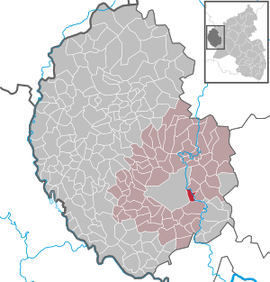
| Location of the local community Hüttingen an der Kyll in the Eifel district of Bitburg-Prüm | ||
  |
||

;_h.jpg)
;_Sehensw%C3%BCrdigkeiten_a.jpg)
Hüttingen an der Kyll is a municipality in the Eifelkreis Bitburg-Prüm in Rhineland-Palatinate . It belongs to the Verbandsgemeinde Bitburger Land .
history
Ceramic finds indicated a settlement from the second century, but these remains were destroyed in the course of the railway construction. Hüttingen is first mentioned in a document in 844 in an exchange document between Count Sigard and the Prüm Monastery as "Uttingtron" (Goerz, Mrh. Reg. I, No. 553. and MARX, Pfarrsystem p. 23). The existence of a chapel with a three-sided choir closure and portal in the western front has been handed down from 1570 .
Until the Napoleonic reign, Hüttingen was part of the Seinsfeld rule and the Bitburg provost in the county of Luxembourg. In 1795 the place came under French administration to Mairie Auw in the canton of Dudeldorf. After the Congress of Vienna in 1815, Hüttingen became Prussian and belonged to the Rhine Province within the Trier administrative district and the Bitburg district. After the Second World War , Hüttingen became part of the newly founded state of Rhineland-Palatinate in 1949. In the course of the Rhineland-Palatinate municipal reform, Hüttingen an der Kyll was integrated into the Bitburg-Land association.
- Population development
The development of the population of Hüttingen an der Kyll, the values from 1871 to 1987 are based on censuses:
|
|
politics
Municipal council
The council in Hüttingen at the Kyll consists of eight council members, who in the local elections on May 26, 2019 in a majority vote were elected, and the honorary mayor as chairman.
coat of arms
|
|
|
| Justification of the coat of arms: The coat of arms indicates that it has belonged to the Prüm Abbey for centuries, which is due to the abbot curves in the lower part of the shield, while the Antonius cross indicates the local and church patron. The Kyll flowing through Hüttingen is symbolized by the wave cut. |
Culture and sights

The Daufenbach in winter

Hüttingen stop

On the platform

Rough channel basin of the Kyll

Bienefeld House
;_der_Daufenbach_a.jpg)
;_Bahnhof_a.jpg)

;_d.jpg)
;_N._Bienefeld-Haus_b.jpg)
Buildings
- Catholic branch church St. Antonius from 1777
- Small brick house by the architect Nikolaus Bienefeld (Schulstrasse 33).
- Former Hüttinger mill "Richhartzmühle" from 1795 (Hauptstrasse 2).
- There are some - some very old - crossroads spread across the municipality .
- Residential building with stepped gable from 1779 that characterizes the townscape.
See also: List of cultural monuments in Hüttingen an der Kyll
Green spaces and recreation
- Natural monument "Hüttinger Wasserfall" in the center of the village
- Adventure trail "Tanzlay" - the gorge with huge limestone slabs and the falling Daufenbach
- Hiking routes from and to Hüttingen an der Kyll.
- The 2011 built Raugerinnebeckenpass of the Kyll at the Hüttinger Mühle.
See also: List of natural monuments in Hüttingen an der Kyll
Regular events
- Annual fair or parish fair is celebrated on the Sunday after January 17th ( Anthony the Great ).
- Traditional rattling or rattling on Good Friday and Holy Saturday.
- Hut burning on the first weekend after Ash Wednesday (so-called Scheef Sunday)
natural reserve
- On June 7, 1995, the nature reserves in the Held near Hüttingen were designated with the number NSG-7232-077 and Wingertsberg near Hüttingen with the number NSG-7232-090.
- On December 8, 1999, the nature reserve Am Münchensberg near Hüttingen was designated with the number NSG-7232-097.
See also: List of nature reserves in the Eifelkreis Bitburg-Prüm
traffic
The Hüttingen stop is on the Eifel route . The demand stop is served by the following local rail passenger trains:
| line | designation | Line course | Clock frequency |
|---|---|---|---|
| RB 22 | Eifel Express |
Cologne Fair / Deutz - Cologne - Euskirchen - Jünkerath - Gerolstein - Bitburg-Erdorf - Hüttingen - Ehrang - Trier (Cologne Fair / Deutz - Gerolstein asRE 22) |
60 min (in the HVZ amplifier Gerolstein – Trier) |
Vehicles from the 620 and 622 series are used.
The tariff of the Verkehrsverbund Region Trier (VRT) applies to all local public transport (ÖPNV )
literature
- Ernst Wackenroder (arr.): The art monuments of the Bitburg district (= Paul Clemen [Hrsg.]: The art monuments of the Rhine province . Volume 12 / I ). Trier 1983, ISBN 3-88915-006-3 , p. 191 (315 p., With 12 plates and 227 ills. In the text. Reprinted by the Schwann edition, Düsseldorf 1927).
- Gerten, Wisniewski, Höster: The Kyll story and stories about an Eifel watercourse. Ed .: Bernd Spindler, Verbandsgemeinde Kyllburg, October 2006.
- Michael Berens: Hüttingen - Filialkirche St. Antonius . In: Geschichtlicher Arbeitskreis Bitburger Land (Hrsg.): The churches and chapels of the Bitburger Land . 1992, p. 50 ( online [PDF; accessed December 13, 2017]).
- Bernd Altmann, Hans Caspary: Bitburg-Prüm district. City of Bitburg, Verbandsgemeinden Bitburg-Land and Irrel (= cultural monuments in Rhineland-Palatinate. Monument topography Federal Republic of Germany . Volume 9.2 ). Wernersche Verlagsgesellschaft, Worms 1997, ISBN 3-88462-132-7 .
Web links
- Local community Hüttingen an der Kyll on the pages of the Verbandsgemeinde Bitburger Land
- To search for cultural assets of the local community Hüttingen an der Kyll in the database of cultural assets in the Trier region .
Individual evidence
- ↑ a b State Statistical Office of Rhineland-Palatinate - population status 2019, districts, municipalities, association communities ( help on this ).
- ↑ State Statistical Office Rhineland-Palatinate: Regional data.
- ^ The Regional Returning Officer Rhineland-Palatinate: Local elections 2019, city and municipal council elections
- ↑ Declaration of the coat of arms. Retrieved July 5, 2016 .
- ↑ Jagdhaus Schulstrasse 33, Hüttingen adKyll. Retrieved February 23, 2017 .
- ↑ Erdorf-Hüttingen hiking route. Retrieved February 23, 2017 .
- ↑ Hüttingen-Philippsheim hiking route. Retrieved February 23, 2017 .
- ↑ Raugerinnebeckenpass of the Kyll. (PDF) Retrieved February 23, 2017 .
- ↑ Raugerinnebecken Hüttingen on the Kyll. (PDF) (No longer available online.) Archived from the original on February 24, 2017 ; accessed on February 23, 2017 .
- ↑ Hüttenbrennen in the Eifel. Retrieved May 1, 2016 .
- ↑ Hut Sunday in the Eifel. Retrieved August 10, 2017 .
- ↑ The nature reserves in Rhineland-Palatinate. Retrieved May 2, 2020 .
- ↑ Deutsche Bahn course book. Retrieved September 26, 2018 .
Bath | Balesfeld | Baustert | Bettingen | Bickendorf | Biersdorf am See | Birtlingen | Brecht | Brimingen | Burbach | Dahlem | Dockendorf | Dudeldorf | Echtershausen | Ehlenz | Enzen | Esslingen | Etteldorf | Feilsdorf | Flowem | Gindorf | Gondorf | Gransdorf | Halsdorf | Hamm | Heilenbach | Hütterscheid | Hüttingen an der Kyll | Idenheim | Idesheim | Ingendorf | Kyllburg | Kyllburgweiler | Ließem | Malberg | Malberg soft | Meckel | Messerich | Metterich | Mülbach | Nattenheim | Neidenbach | Neuheilenbach | Niederstedem | Niederweiler | Oberkail | Oberstedem | Oberweiler | Oberweis | Olsdorf | Orsfeld | Pickleneem | Rittersdorf | Röhl | Saint Thomas | Sharply cheap | Schleid | Seffern | Seffer soft | Field of being | Steinborn | Stockem | Sülm | Trimport | Usch | Wettlingen | Wiersdorf | Wilsecker | Wissmannsdorf | Wolsfeld | Zendscheid