
Malberg (Eifel)
| coat of arms | Germany map | |
|---|---|---|
_COA.svg)
|
Coordinates: 50 ° 3 ′ N , 6 ° 35 ′ E |
|
| Basic data | ||
| State : | Rhineland-Palatinate | |
| County : | Eifel district Bitburg-Prüm | |
| Association municipality : | Bitburger Land | |
| Height : | 280 m above sea level NHN | |
| Area : | 6.6 km 2 | |
| Residents: | 565 (Dec. 31, 2019) | |
| Population density : | 86 inhabitants per km 2 | |
| Postal code : | 54655 | |
| Area code : | 06563 | |
| License plate : | BIT, PRÜ | |
| Community key : | 07 2 32 075 | |
| Association administration address: | Hubert-Prim-Strasse 7 54634 Bitburg |
|
| Mayoress : | Sabine Buhr | |
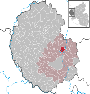
| Location of the local community Malberg in the Eifelkreis Bitburg-Prüm | ||
  |
||

;_Ansicht_a.jpg)
.jpg)
Malberg is a municipality in the Eifelkreis Bitburg-Prüm in Rhineland-Palatinate . It belongs to the Verbandsgemeinde Bitburger Land .
geography
Malberg is located on the Kyll in the Eifel . The district Mohrweiler with 176 inhabitants belongs to the municipality (as of 2005).
history
The place Malberg belonged to the Bitburg quarter in the Duchy of Luxembourg until the end of the 18th century . In addition to the castle and the village of Malberg, the Malberg dominion also included Malbergoft and part of Neidenbach .
After 1792 French revolutionary troops occupied the Austrian Netherlands , to which the Duchy of Luxembourg and thus Malberg belonged at the time, and annexed it in 1795 . Under French administration , Malberg was assigned to the canton of Bitburg in 1795 , which was part of the Bitburg arrondissement in the Forests department . Malberg later became the seat of a mairie .
Due to the resolutions passed at the Congress of Vienna , the region became part of the Kingdom of Prussia in 1815 . Under the Prussian administration came in 1816, the mayor Malberg the newly formed Bitburg in Trier .
- Population development
The development of the population of Malberg, the values from 1871 to 1987 are based on censuses:
|
|
politics
Municipal council
The council in Malberg consists of twelve council members, who in the local elections on May 26, 2019 in a majority vote were elected, and the volunteer local mayor as chairman.
coat of arms
|
|
Blazon : “In a shield divided in the middle from blue to silver; above nine (5: 4) golden balls, below a red label. " |
| Justification of the coat of arms: The Malberg court seal from 1565 already shows a knight who was identified as Saint Quirinus as a seal image. Saint Quirinus has been the local and church patron of Malberg for centuries. His sign are 9 golden balls, they appear again in the upper part of the municipal coat of arms. The gentlemen of Malberg have had the red label in white since the 14th century. It appears in all of the coat of arms of the von Malberg family, including the coat of arms of Veyder. It is the symbol of Malberg and was therefore included in the municipal coat of arms. The coat of arms was approved by the government in 1974. |
Culture and sights
Buildings


Village and castle Malberg stand as monument zone under monument protection . In addition, the list of cultural monuments shows 36 individual monuments, including the baroque palace complex on a ridge surrounded by the Kyll , the Catholic parish church of St. Quirin and the Catholic branch church of St. Maria vom Gute Rat in Mohrweiler.
See also
Personalities
- Kuno von Malberg , the Great, * 1238 † 1262
- Gerhard von Malberg , † November 26, 1246, Grand Master of the Teutonic Order
- Rudolf von Malberg † ~ 1280
- Henry II of Finstingen , † April 26, 1286 in Boulogne-sur-Mer , Archbishop and Elector of Trier
Web links
- Internet presence of the Förderverein Schloss Malberg - information including current dates at the castle
- Local community Malberg on the website of the Verbandsgemeinde Bitburger Land
- To search for cultural assets of the local community Malberg in the database of cultural assets in the Trier region .
Individual evidence
- ↑ a b State Statistical Office of Rhineland-Palatinate - population status 2019, districts, municipalities, association communities ( help on this ).
- ^ Georg Bärsch : Description of the government district of Trier , Volume 2, Trier, Lintz, 1846, p. 23 ( Google Books )
- ↑ State Statistical Office Rhineland-Palatinate - regional data
- ^ The Regional Returning Officer Rhineland-Palatinate: Local elections 2019, city and municipal council elections.
Bath | Balesfeld | Baustert | Bettingen | Bickendorf | Biersdorf am See | Birtlingen | Brecht | Brimingen | Burbach | Dahlem | Dockendorf | Dudeldorf | Echtershausen | Ehlenz | Enzen | Esslingen | Etteldorf | Feilsdorf | Flowem | Gindorf | Gondorf | Gransdorf | Halsdorf | Hamm | Heilenbach | Hütterscheid | Hüttingen an der Kyll | Idenheim | Idesheim | Ingendorf | Kyllburg | Kyllburgweiler | Ließem | Malberg | Malberg soft | Meckel | Messerich | Metterich | Mülbach | Nattenheim | Neidenbach | Neuheilenbach | Niederstedem | Niederweiler | Oberkail | Oberstedem | Oberweiler | Oberweis | Olsdorf | Orsfeld | Pickleneem | Rittersdorf | Röhl | Saint Thomas | Sharply cheap | Schleid | Seffern | Seffer soft | Field of being | Steinborn | Stockem | Sülm | Trimport | Usch | Wettlingen | Wiersdorf | Wilsecker | Wissmannsdorf | Wolsfeld | Zendscheid