
Echtershausen
| coat of arms | Germany map | |
|---|---|---|

|
Coordinates: 50 ° 1 ′ N , 6 ° 25 ′ E |
|
| Basic data | ||
| State : | Rhineland-Palatinate | |
| County : | Eifel district Bitburg-Prüm | |
| Association municipality : | Bitburger Land | |
| Height : | 290 m above sea level NHN | |
| Area : | 2.49 km 2 | |
| Residents: | 105 (Dec 31, 2019) | |
| Population density : | 42 inhabitants per km 2 | |
| Postal code : | 54636 | |
| Area code : | 06569 | |
| License plate : | BIT, PRÜ | |
| Community key : | 07 2 32 029 | |
| Association administration address: | Hubert-Prim-Strasse 7 54634 Bitburg |
|
| Website : | ||
| Local Mayor : | Norbert Fleckner | |
| Location of the community of Echtershausen in the Eifelkreis Bitburg-Prüm | ||
  |
||


Echtershausen is a municipality in the Eifelkreis Bitburg-Prüm in Rhineland-Palatinate . It has been part of the Bitburger Land community since July 1, 2014 .
geography
The community is located in the South Eifel nature park, around 10 km northwest of the district town of Bitburg . The Prüm runs east of the village and flows into the Bitburg reservoir, 1 km from Echtershausen . Of the municipality area, which is quite small at 2.49 km², 40% are used for agriculture, 46% are forest.
history
The place was first mentioned in a document in 1325 as "Ochtershausen". The ending “–hausen” comes from the clearing time in the 9th – 11th centuries. Century.
Until the end of the 18th century, the place belonged to the Luxembourg rule Hamm . In 1794 French revolutionary troops occupied the Austrian Netherlands , to which the Duchy of Luxembourg belonged, and annexed it in October 1795 . From 1795 to 1814 Echtershausen belonged to the canton Bitburg in the department of forests . Around 1800 it was administered by the Mairie Biersdorf , from which the Prussian mayor's office Biersdorf emerged in 1815 , which was assigned to the Bitburg district in the Trier administrative district in 1816 and the Rhine province in 1822 . In 1856 the community came to the mayor's office Bickendorf (renamed to Amt Bickendorf in 1927), from which the Verbandsgemeinde Bitburg-Land was formed in 1970 with additional offices . Since July 1, 2014, the community has been part of the Bitburger Land association.
Population development
For 1473 and 1493, the Luxembourg Fireplace Directory shows three households in Enchtershusen . In 1656 the village had grown to three and in 1848 to 16 houses with 131 inhabitants. The previous high was reached in 1871 with 167 inhabitants.
The development of the population of the community of Echtershausen, the values from 1871 to 1987 are based on censuses:
|
|
politics
Municipal council
The community council in Echtershausen consists of six council members, who were elected in the local elections on May 26, 2019 in a majority vote, and the honorary local mayor as chairman.
coat of arms
|
|
|
| Justification of the coat of arms: The shield colors blue and silver are an expression of the longstanding membership in the Duchy of Luxembourg. The rising tip symbolizes the cone-like elevation within the demarcation, the wavy bar stands for the Prüm. The plow wheel in the lower part of the coat of arms is an indication of the original agricultural structure of the municipality. |
Attractions
In the area of the town center there is a slate rock that reminds of the earlier western course of the Prüm around the town. Also worth seeing are a chapel from 1892 and the agricultural farms spread across the district .
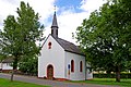
St. Maria Chapel (1894)

Chapel interior

Pietà (18th century)

Ceiling painting

Four-pass window (1894)
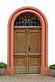
portal
_01.jpg)
_03.jpg)
_06.jpg)
_07.jpg)
_10.jpg)
_09.jpg)
See also: List of cultural monuments in Echtershausen
See also: List of natural monuments in Echtershausen
economy
Due to the nearby Bitburg reservoir, among other things , Echtershausen is now a touristy municipality. A village inn and guesthouse and several holiday apartments are evidence of this . The importance of agriculture has declined sharply in recent years compared to the surrounding area; the area used for agriculture was more than halved between 1971 and 2005. Most of the employees work in Bitburg, the Trier region and Luxembourg .
literature
- Ernst Wackenroder (arr.): The art monuments of the Bitburg district (= Paul Clemen [Hrsg.]: The art monuments of the Rhine province . Volume 12 / I ). Trier 1983, ISBN 3-88915-006-3 , p. 23 (315 p., With 12 plates and 227 figs. In the text. Reprinted by the Schwann edition, Düsseldorf 1927).
Web links
- Local community Echtershausen on the website of the Verbandsgemeinde Bitburger Land
- To search for cultural assets of the community of Echtershausen in the database of cultural assets in the Trier region .
Individual evidence
- ↑ State Statistical Office of Rhineland-Palatinate - population status 2019, districts, communities, association communities ( help on this ).
- ↑ a b State Statistical Office Rhineland-Palatinate: Regional data.
- ^ The Regional Returning Officer Rhineland-Palatinate: Local elections 2019, city and municipal council elections
- ^ Entry on the coat of arms of the community of Echtershausen in the database of cultural assets in the Trier region ; accessed on September 1, 2016.
Bath | Balesfeld | Baustert | Bettingen | Bickendorf | Biersdorf am See | Birtlingen | Brecht | Brimingen | Burbach | Dahlem | Dockendorf | Dudeldorf | Echtershausen | Ehlenz | Enzen | Esslingen | Etteldorf | Feilsdorf | Flowem | Gindorf | Gondorf | Gransdorf | Halsdorf | Hamm | Heilenbach | Hütterscheid | Hüttingen an der Kyll | Idenheim | Idesheim | Ingendorf | Kyllburg | Kyllburgweiler | Ließem | Malberg | Malberg soft | Meckel | Messerich | Metterich | Mülbach | Nattenheim | Neidenbach | Neuheilenbach | Niederstedem | Niederweiler | Oberkail | Oberstedem | Oberweiler | Oberweis | Olsdorf | Orsfeld | Pickleneem | Rittersdorf | Röhl | Saint Thomas | Sharply cheap | Schleid | Seffern | Seffer soft | Field of being | Steinborn | Stockem | Sülm | Trimport | Usch | Wettlingen | Wiersdorf | Wilsecker | Wissmannsdorf | Wolsfeld | Zendscheid