
Brimingen
| coat of arms | Germany map | |
|---|---|---|

|
Coordinates: 49 ° 58 ' N , 6 ° 22' E |
|
| Basic data | ||
| State : | Rhineland-Palatinate | |
| County : | Eifel district Bitburg-Prüm | |
| Association municipality : | Bitburger Land | |
| Height : | 400 m above sea level NHN | |
| Area : | 5.92 km 2 | |
| Residents: | 95 (Dec. 31, 2019) | |
| Population density : | 16 inhabitants per km 2 | |
| Postal code : | 54646 | |
| Area code : | 06522 | |
| License plate : | BIT, PRÜ | |
| Community key : | 07 2 32 502 | |
| LOCODE : | DE RJG | |
| Association administration address: | Hubert-Prim-Strasse 7 54634 Bitburg |
|
| Website : | ||
| Local Mayor : | Peter Neyses | |
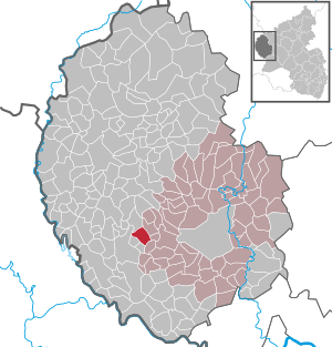
| Location of the local community Brimingen in the Eifelkreis Bitburg-Prüm | ||
  |
||

.JPG)
;_Bev%C3%B6lkerungsentwicklung_a.jpg)
;_Hofanlage_von_1772_a.jpg)
Brimingen is a municipality in the Eifelkreis Bitburg-Prüm in Rhineland-Palatinate . It has been part of the Bitburger Land community since July 1, 2014 .
geography
Brimingen is located in the western Eifel on a ridge between Enz and Prüm . The state border with Luxembourg is about 10 km west of the town. To Brimingen also includes a part of the otherwise to Utscheid belonging hamlet Neuhaus.
The hamlet of Hisel belongs to the local community .
Neighboring communities are: Baustert , Burg , Mülbach , Olsdorf , Niehl and Utscheid .
history
Several barrows and Roman stray finds indicate that the area was settled early. The first written mention as "Bremme" comes from the year 1473. In 1636 almost all residents of the village fell victim to the plague , so that in 1656 the nine houses of Brimingen were all dilapidated.
High quality lime was burned in Brimingen until the end of the 19th century.
Until the end of the 18th century Brimingen belonged to the lordship of Neuerburg in the Duchy of Luxembourg , the place was assigned to the court and the dairy Oberweis .
In 1794 French revolutionary troops occupied the Austrian Netherlands , to which the Duchy of Luxembourg belonged, and annexed it in October 1795 . From 1795 to 1814 the place belonged to the canton Neuerburg in the department of forests .
In 1815, the former Luxembourg area east of the Sauer and Our was assigned to the Kingdom of Prussia at the Congress of Vienna . So that the community came Brimingen 1816 Bitburg in Trier in the Grand Duchy of the Lower Rhine , which in 1822 Rheinprovinz opened. Brimingen was initially administered by the Mayor's Office Outscheid and from 1856 it belonged to the Mayor's Office of Baustert (renamed to "Amt Baustert" in 1927).
The Hisel parish was incorporated into the Brimingen parish on January 1, 2018.
- Population development
The development of the population of Brimingen, the values from 1871 to 1987 are based on censuses:
|
|
politics
Municipal council
The local council in Brimingen consists of six council members, who were elected by a majority vote in the local elections in 2017 , and the honorary local mayor as chairman.
coat of arms
|
|
Blazon : "Under a red shield head, in it 5 gold rings, in gold a green plant, which is designed according to the house brand on Mayisch-Stockgut." |
| Justification of the coat of arms: The 5 rings stand for the five former stock estates in the village and with the colors red and gold also testify to the possession of the Counts of Manderscheid / Blankenheim (Reign of Neuerburg in former Brimingen) The green plant on a golden background shows the house coat of arms of the Mayisch-Stockgut, built in 1730. |
Culture and sights
- The town center is the location of some very old farms that have been renovated in recent years.
- The architect Oswald Mathias Ungers extensively restored the stately Winkelhof from 1840 (Dorfstrasse 10) in 1990/1991. The roof received a natural slate covering in English. Windows, doors and floors have been refurbished in accordance with listed buildings. The lambris of a room was also restored on the first floor .
- There are also several crossroads across the municipality .
- Parts of the former Nike position in town (a US anti-aircraft missile program from the Cold War).
See also: List of cultural monuments in Brimingen
Economy and Infrastructure
Brimingen is today an agricultural community. With 272 hectares, a large part of the municipality is used for agriculture. Most of the workers are employed in the district town of Bitburg .
The hotel "HOTEL AM HOHNERSBERG" offers overnight accommodation. It is located directly on federal highway 50.
Companies
Girards Baumaschinen GmbH, Eifelimbiss, Propan Vertriebsgesellschaft mbH
In June 2002, two Nordex N62 wind turbines (100 m total height, tower height 69 m, diameter 62 m) with a nominal output of 1300 kW each from Thewindpower were put into operation in the Brimingen wind farm ("Auf Herrel" ⊙ ) .
In the spring of 2009, the Dunoair type E-48 wind turbine was put into operation on the “Am Hohnersberg” ( ⊙ ) site near Brimingen . The plant delivers an annual production of 1.3 million kilowatt hours and thus supplies 360 households with electricity.
See also: List of wind turbines in Rhineland-Palatinate
traffic
The community is accessed via the K 10 district road. Federal highway 50 runs immediately to the west of the village and leads to the Luxembourg state border and Bitburg.
literature
- Rudolf Schaal, collaborator: Adolf Valentin: The villages of the Baustert parish in the Bitburger Kreis- und Intellektivenblatt (1841–1867) (= historical study group of the Baustert parish, Eifel. [Ed.]: Heimatbuch ous der Bouster Poar . Volume 4 ). Baustert 2014, p. 137-160 .
- Theo Kyll: Around the Honersberg (= historical working group of the parish of Baustert, Eifel. [Hrsg.]: Heimatbuch ous der Bouster Poar . Volume 4 ). Baustert 2010, p. 102-107 .
Web links
- Local community Brimingen on the website of the Verbandsgemeinde Bitburger Land
- To search for cultural assets of the Brimingen community in the database of cultural assets in the Trier region .
- Hisel and Brimingen merge

Brimingen village fountain with Watzbach

Magnificent house; Dorfstrasse 5
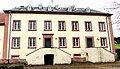
Heinzenhaus / Ottenhof Dorfstrasse 10
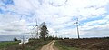
Brimingen Am Hohnersberg energy park
.jpg)


;_2016.JPG)
Individual evidence
- ↑ State Statistical Office of Rhineland-Palatinate - population status 2019, districts, communities, association communities ( help on this ).
- ↑ State Statistical Office Rhineland-Palatinate (ed.): Official directory of the municipalities and parts of the municipality. Status: January 2019 [ Version 2020 is available. ] . S. 110 (PDF; 3 MB).
- ↑ Brimingen lime distillery. Retrieved July 5, 2018 .
- ↑ Brimingen and Hisel will merge in 2018. Accessed January 1, 2016 .
- ↑ Brimingen and Hisel go together in 2018. Retrieved December 13, 2017 .
- ↑ State Statistical Office Rhineland-Palatinate: Regional data.
- ^ Election result Brimingen 2017
- ^ State Office for the Preservation of Monuments in Rhineland-Palatinate (ed.): Annual reports 1989–1991 (= year 44–46 ). Wernersche Verlagsgesellschaft, 1994, ISSN 0341-9967 , p. 114-115 .
- ↑ Former Nike position in Brimingen (Eifel). Retrieved December 13, 2017 .
- ↑ Hotel Hohnersberg. Retrieved December 13, 2017 .
- ^ Girards Baumaschinen GmbH, Brimingen (Eifel). Retrieved December 13, 2017 .
- ↑ Eifelimbiss, Brimingen (Eifel). Retrieved December 13, 2017 .
- ^ Propan Vertriebsgesellschaft mbH, Brimingen (Eifel). Retrieved December 13, 2017 .
- ^ Brimingen (Germany). The Windpower, accessed April 27, 2016 .
- ↑ "Am Hohnersberg" wind farm. Dunoair, accessed April 27, 2016 .
Bath | Balesfeld | Baustert | Bettingen | Bickendorf | Biersdorf am See | Birtlingen | Brecht | Brimingen | Burbach | Dahlem | Dockendorf | Dudeldorf | Echtershausen | Ehlenz | Enzen | Esslingen | Etteldorf | Feilsdorf | Flowem | Gindorf | Gondorf | Gransdorf | Halsdorf | Hamm | Heilenbach | Hütterscheid | Hüttingen an der Kyll | Idenheim | Idesheim | Ingendorf | Kyllburg | Kyllburgweiler | Ließem | Malberg | Malberg soft | Meckel | Messerich | Metterich | Mülbach | Nattenheim | Neidenbach | Neuheilenbach | Niederstedem | Niederweiler | Oberkail | Oberstedem | Oberweiler | Oberweis | Olsdorf | Orsfeld | Pickleneem | Rittersdorf | Röhl | Saint Thomas | Sharply cheap | Schleid | Seffern | Seffer soft | Field of being | Steinborn | Stockem | Sülm | Trimport | Usch | Wettlingen | Wiersdorf | Wilsecker | Wissmannsdorf | Wolsfeld | Zendscheid