
Dockendorf
| coat of arms | Germany map | |
|---|---|---|

|
Coordinates: 49 ° 56 ' N , 6 ° 27' E |
|
| Basic data | ||
| State : | Rhineland-Palatinate | |
| County : | Eifel district Bitburg-Prüm | |
| Association municipality : | Bitburger Land | |
| Height : | 253 m above sea level NHN | |
| Area : | 5.83 km 2 | |
| Residents: | 211 (Dec. 31, 2019) | |
| Population density : | 36 inhabitants per km 2 | |
| Postal code : | 54636 | |
| Area code : | 06568 | |
| License plate : | BIT, PRÜ | |
| Community key : | 07 2 32 026 | |
| Association administration address: | Hubert-Prim-Strasse 7 54634 Bitburg |
|
| Website : | ||
| Local Mayor : | Stefan Rodens | |
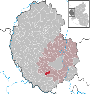
| Location of the local community Dockendorf in the Eifelkreis Bitburg-Prüm | ||
  |
||


Dockendorf is a municipality in the Eifelkreis Bitburg-Prüm in Rhineland-Palatinate . It has been part of the Bitburger Land community since July 1, 2014 .
geography
The village is located in the southern Eifel , about 10 km southwest of the district town of Bitburg . It is embedded in the western edge of the Nims Valley and is traversed by a stream that flows into the Nims . The highest point within the municipality is the Großerbüsch at 379 m above sea level. NHN , the lowest ground point is 225 m above sea level. NHN reached at Dockendorfer Mühle. At 60%, a comparatively large proportion of the 5.83 km² municipal area is used for agriculture, 30% are forest (as of 2017).
The Buchenberg, Dockendorfermühle, Eichelhof and Hof Wiesengrund residential areas also belong to Dockendorf.
history
The place in its present form can be traced back to the time of the Frankish conquest. However, the Romans had already settled parts of the present-day district, which u. a. is proven by traces of a medieval tower castle near the Dockendorfer mill. Dockendorf was first mentioned in a document in 1270. For many years the place belonged to the Luxembourg provost office Bitburg and from 1816 to the Prussian district Bitburg . During the French period, Dockendorf was a mairie , which later existed as a mayor's office until 1914. This then went into the mayor's office Wolsfeld (from 1927 Wolsfeld office), which was merged with four other offices to form the Bitburg-Land community during the Rhineland-Palatinate functional and territorial reform in 1970 . It has been part of the new Bitburger Land association since July 1, 2014 .
- Population development
The development of the population of Dockendorf, the values from 1871 to 1987 are based on censuses:
|

politics
Municipal council
The municipal council in Dockendorf consists of six council members, who were elected by a majority vote in the local elections on May 26, 2019 , and the honorary local mayor as chairman.
coat of arms
|
|
Blazon : “In gold, a blue sloping bar covered with a silver sword. Above four red bars, covered with a black lion. Below is a green apple tree. " |
| Justification for the coat of arms: The attribute of the church patron, St. Martin, is shown in the inclined beam of the coat of arms. The lords of Enschringen had an extensive manorial rule in Dockendorf, the black lion on the red and gold bar field is taken from their coat of arms, while the green tree stands as a symbol for agriculture and fruit growing. |
Culture and sights
Numerous well-preserved and listed farmhouses from the 18th and 19th centuries are spread across the municipality . The buildings worth seeing in Dockendorf also include the forest chapel and the parish church as well as the old rectory, which was built in four architectural styles. The latter has been restored inside and out and is also regarded as an important architectural monument nationwide. A total of five crossroads in the Dockendorf district date from the 17th to 19th centuries . The nearby nature reserve “ Scharren bei Dockendorf ” (Keupterkuppe) is home to some very rare plant species.
See also: List of cultural monuments in Dockendorf
economy
Dockendorf is an extraordinarily agricultural community. Some full-time and part-time farms are evidence of this. In recent years the area used for agriculture has increased in contrast to some other municipalities in the surrounding area. In addition, a construction company and a distillery are located in the industrial sector . Most of the workers in Dockendorf commute to Bitburg, Trier and Luxembourg .
Bundesstrasse 257 runs one kilometer east of the village . The next motorway junction on the A 60 is Bitburg and is about 10 km away.
literature
- Ernst Wackenroder (arr.): The art monuments of the Bitburg district (= Paul Clemen [Hrsg.]: The art monuments of the Rhine province . Volume 12 / I ). Trier 1983, ISBN 3-88915-006-3 , p. 82 (315 p., With 12 plates and 227 ills. In the text. Reprinted by the Schwann edition, Düsseldorf 1927).
Web links
- Local community Dockendorf on the website of the Verbandsgemeinde Bitburger Land
- To search for cultural goods of the local community Dockendorf in the database of cultural goods in the Trier region .
Individual evidence
- ↑ State Statistical Office of Rhineland-Palatinate - population status 2019, districts, communities, association communities ( help on this ).
- ↑ a b State Statistical Office Rhineland-Palatinate: Regional data.
- ↑ State Statistical Office Rhineland-Palatinate (ed.): Official directory of the municipalities and parts of the municipality. Status: January 2019 [ Version 2020 is available. ] . S. 106 (PDF; 3 MB).
- ↑ Local elections 2019, city and municipal council elections. The Regional Returning Officer Rhineland-Palatinate, accessed on August 14, 2019 .
- ^ Entry on the coat of arms of the community Dockendorf in the database of cultural assets in the Trier region ; accessed on September 1, 2016.
Bath | Balesfeld | Baustert | Bettingen | Bickendorf | Biersdorf am See | Birtlingen | Brecht | Brimingen | Burbach | Dahlem | Dockendorf | Dudeldorf | Echtershausen | Ehlenz | Enzen | Esslingen | Etteldorf | Feilsdorf | Flowem | Gindorf | Gondorf | Gransdorf | Halsdorf | Hamm | Heilenbach | Hütterscheid | Hüttingen an der Kyll | Idenheim | Idesheim | Ingendorf | Kyllburg | Kyllburgweiler | Ließem | Malberg | Malberg soft | Meckel | Messerich | Metterich | Mülbach | Nattenheim | Neidenbach | Neuheilenbach | Niederstedem | Niederweiler | Oberkail | Oberstedem | Oberweiler | Oberweis | Olsdorf | Orsfeld | Pickleneem | Rittersdorf | Röhl | Saint Thomas | Sharply cheap | Schleid | Seffern | Seffer soft | Field of being | Steinborn | Stockem | Sülm | Trimport | Usch | Wettlingen | Wiersdorf | Wilsecker | Wissmannsdorf | Wolsfeld | Zendscheid