
Olsdorf (Eifel)
| coat of arms | Germany map | |
|---|---|---|

|
Coordinates: 49 ° 57 ' N , 6 ° 23' E |
|
| Basic data | ||
| State : | Rhineland-Palatinate | |
| County : | Eifel district Bitburg-Prüm | |
| Association municipality : | Bitburger Land | |
| Height : | 350 m above sea level NHN | |
| Area : | 3.14 km 2 | |
| Residents: | 97 (Dec. 31, 2019) | |
| Population density : | 31 inhabitants per km 2 | |
| Postal code : | 54646 | |
| Area code : | 06527 | |
| License plate : | BIT, PRÜ | |
| Community key : | 07 2 32 100 | |
| Association administration address: | Hubert-Prim-Strasse 7 54634 Bitburg |
|
| Website : | ||
| Local Mayor : | Patrick Adolph | |
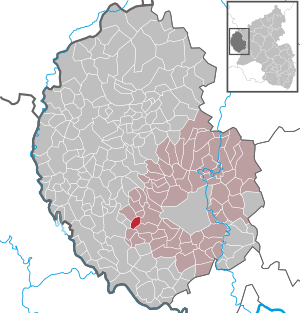
| Location of the local community Olsdorf in the Eifelkreis Bitburg-Prüm | ||
  |
||

Olsdorf is a municipality in the Eifelkreis Bitburg-Prüm in Rhineland-Palatinate . It belongs to the Verbandsgemeinde Bitburger Land .
;_2016_a.jpg)
;_Feuerwehr-_und_B%C3%BCrgerhaus.jpg)
geography
location
Olsdorf is located in the southwest Eifel about 10 km west of the district town of Bitburg. The municipality extends on the plateau between Prüm and Our . An exceptionally high proportion of the 3.14 km² district of Olsdorf is used for agriculture (85%), only 7% are forest. Immediately north of the village runs the federal highway 50 , which leads to the Luxembourg state border and to Bitburg.
Olsdorf also includes the Gerlingsheim, Raison, Hoorhof and Kobenheim residential areas .
Neighboring communities
Neighboring communities are: Bettingen , Oberweis , Brimingen and Niehl .
climate
The annual precipitation is 841 mm. The precipitation is in the upper third of the values recorded in Germany. Lower values are registered at 71% of the measuring stations of the German Weather Service . The driest month is April, with the most rainfall in December. In December there is 1.4 times more rainfall than in April. Precipitation varies only minimally and is extremely evenly distributed over the year. Lower seasonal fluctuations are recorded at only 2% of the measuring stations .
history
In the area of "Oberolsdorf" remains of settled settlement by the Romans were found. The first written mention of the place comes from the year 1200, when the place still appeared as "Alesdorf juxta Bettingen". In the later Middle Ages the village - then called "Ailstorf" - belonged to the Bettingen lordship , and in 1473 three campfire sites were recorded. Until the end of the 18th century, Olsdorf belonged to the Duchy of Luxembourg .
In 1794 French revolutionary troops occupied the Austrian Netherlands , to which the Duchy of Luxembourg belonged, and annexed it in October 1795 . From 1795 to 1814 Olsdorf belonged to the canton Bitburg in the department of forests . After the region was taken over by the Kingdom of Prussia (1815), the place came to the Bitburg district in the Trier administrative district in 1816 , which was part of the Rhine province from 1822 . Olsdorf was administered by the mayor's office Baustert .
The municipal area was enlarged in 1905 when the Hoorhof, built in 1767, was incorporated into the municipality of Olsdorf.
- Population development
The development of the population of Olsdorf, the values from 1871 to 1987 are based on censuses:
|
|
politics
Municipal council
The local council in Olsdorf consists of six council members, who were elected by a majority vote in the local elections on May 26, 2019 , and the honorary local mayor as chairman.
coat of arms
|
|
|
| Justification for the coat of arms: The silver plow wheel on a blue background is an expression of the agricultural structure of the place, ascribed to the attribute of the church patron St. Rochus, a golden pilgrim staff. |
Culture and sights
;_Sehensw%C3%BCrdigkeiten_a.jpg)
- The Catholic Chapel of St. Rochus was built in 1928.
- Together with the Hoorhof belonging to the chapel and the private cemetery, it forms the historic entrance to the town.
- Three monumental crossroads distributed throughout the municipality are worth seeing .
See also: List of cultural monuments in Olsdorf
Economy and Infrastructure
An exceptionally high proportion of the 3.14 km² district of Olsdorf is used for agriculture (85%), only 7% are forest.
Companies
The citizens' cooperative Energiegewinner eG Olsdorf has a wind turbine. The Suzlon S88 wind turbine has a nominal output of 2.1 megawatts and can supply 550 four-person households with electricity per year.
See also: List of wind turbines in Rhineland-Palatinate
Public facilities
Olsdorf is the location of a volunteer fire brigade , whose fire station also serves as a local event location. The church belongs to the parish of Bettingen.
traffic
The community is accessed through the district roads K 11 and K 13 . Immediately north of the village runs the federal highway 50 , which leads to the Luxembourg state border and to Bitburg.
literature
- Ernst Wackenroder (arr.): The art monuments of the Bitburg district (= Paul Clemen [Hrsg.]: The art monuments of the Rhine province . Volume 12 / I ). Trier 1983, ISBN 3-88915-006-3 , p. 33 (315 p., With 12 plates and 227 illus. In the text. Reprinted by the Schwann edition, Düsseldorf 1927).
- Michael Berens: Rochus Chapel at the Hoorhof . In: Geschichtlicher Arbeitskreis Bitburger Land (Hrsg.): The churches and chapels of the Bitburger Land . S. 75 ( online [PDF; accessed December 5, 2017]).
Web links
- Local community Olsdorf on the website of the Verbandsgemeinde Bitburger Land
- To search for cultural assets of the local community Olsdorf (Eifel) in the database of cultural assets in the Trier region .
Individual evidence
- ↑ State Statistical Office of Rhineland-Palatinate - population status 2019, districts, communities, association communities ( help on this ).
- ↑ State Statistical Office Rhineland-Palatinate (ed.): Official directory of the municipalities and parts of the municipality. Status: January 2019 [ Version 2020 is available. ] . S. 108 (PDF; 3 MB).
- ↑ State Statistical Office Rhineland-Palatinate: Regional data.
- ^ The Regional Returning Officer Rhineland-Palatinate: Local elections 2019, city and municipal council elections
- ↑ Hoorhof with Rochuskapelle. Retrieved June 21, 2016 .
- ↑ Citizens' Association Energiegewinner eG Olsdorf. Retrieved May 24, 2016 .
Bath | Balesfeld | Baustert | Bettingen | Bickendorf | Biersdorf am See | Birtlingen | Brecht | Brimingen | Burbach | Dahlem | Dockendorf | Dudeldorf | Echtershausen | Ehlenz | Enzen | Esslingen | Etteldorf | Feilsdorf | Flowem | Gindorf | Gondorf | Gransdorf | Halsdorf | Hamm | Heilenbach | Hütterscheid | Hüttingen an der Kyll | Idenheim | Idesheim | Ingendorf | Kyllburg | Kyllburgweiler | Ließem | Malberg | Malberg soft | Meckel | Messerich | Metterich | Mülbach | Nattenheim | Neidenbach | Neuheilenbach | Niederstedem | Niederweiler | Oberkail | Oberstedem | Oberweiler | Oberweis | Olsdorf | Orsfeld | Pickleneem | Rittersdorf | Röhl | Saint Thomas | Sharply cheap | Schleid | Seffern | Seffer soft | Field of being | Steinborn | Stockem | Sülm | Trimport | Usch | Wettlingen | Wiersdorf | Wilsecker | Wissmannsdorf | Wolsfeld | Zendscheid