
Banská Štiavnica
| Banská Štiavnica | |||
|---|---|---|---|
| coat of arms | map | ||

|
|
||
| Basic data | |||
| State : | Slovakia | ||
| Kraj : | Banskobystrický kraj | ||
| Okres : | Banská Štiavnica | ||
| Region : | Pohrony | ||
| Area : | 46.738 km² | ||
| Residents : | 10,004 (Dec 31, 2019) | ||
| Population density : | 214 inhabitants per km² | ||
| Height : | 600 m nm | ||
| Postal code : | 969 24 | ||
| Telephone code : | 0 45 | ||
| Geographic location : | 48 ° 28 ' N , 18 ° 54' E | ||
| License plate : | BS | ||
| Kód obce : | 516643 | ||
| structure | |||
| Community type : | city | ||
| Urban area structure: | 5 districts | ||
| Administration (as of November 2018) | |||
| Mayor : | Nadežda Babiaková | ||
| Address: | Mestský úrad Banská Štiavnica Radničné námestie 1 96924 Banská Štiavnica |
||
| Website: | www.banskastiavnica.sk | ||
| Statistics information on statistics.sk | |||

Banská Štiavnica ( , until 1927 in Slovak Baňská Štiavnica ; German Schemnitz or Schebnitz, Hungarian Selmecbánya ) is the oldest mountain town in Slovakia . In 1993, the city was in the world heritage directory of the UNESCO added. As of December 31, 2019, the city had 10,004 inhabitants.
geography

The city is located in the middle of the Schemnitz Mountains , an extinct volcanic mountain range, which is also legally protected as the Štiavnické vrchy protected landscape area . The stream Štiavnička flows through the city and runs almost completely underground in the city area. Two mountains rise around the small basin in which the city is located: the Kalvária (height 726 m nm ) and the Sitno further south (height 1009 m nm ; highest elevation of the Štiavnické vrchy ). While the valley basin has been largely deforested, spruce, pine and fir trees grow in the mountains. The surrounding landscape is also characterized by a number of so-called tajchy (reservoirs). Banská Štiavnica is 30 kilometers from Zvolen , 47 kilometers from the regional capital Banská Bystrica and about 175 kilometers from the capital Bratislava (road distance). The municipal area covers approximately 47 square kilometers.
The city is made up of the following districts:
- Banky (1971–1998 parish of Vyhne )
- Banská Štiavnica (German Schemnitz )
- Počúvadlianske Jazero (German Pockhauser pond )
- Sitnianska (previously also "Podsitnianska", incorporated in 1971; German Neustift )
- Štefultov (incorporated into Sitnianska around 1850; German Steffelsdorf )
The following information relates to the straight line distance to the nearest town center and the distances are commercially rounded to half a kilometer. Cities are highlighted in bold.
|
Vyhne 8.5 km |
Sklené Teplice , Žiar nad Hronom 8 km, 15 km |
Banská Belá , Zvolen 3.5 km, 21.5 km |
|
Hodruša-Hámre , Žarnovica 9.5 km, 14 km |
.svg)
|
Bansky Studenec 6 km |
|
Štiavnické Bane , Levice 3 km, 34 km |
Ilija , Šahy 4.5 km, 43.5 km |
Svätý Anton , Krupina 5 km, 17.5 km |
history


The place is an old settlement with first proven finds from the Stone Age . After other cultures, the Celts settled towards the end of the 3rd century BC. And extracted gold from the rivers. It was a seasonal settlement that was only inhabited in months suitable for mining. Imported Roman ceramics were discovered in the Glanzenberg gallery in 1982, which indicates trade with the Romans. For the period from the end of the 3rd to the 11th century, however, no finds that could indicate human presence have been found.
Only with the development of the area by the early Hungarian state is mining in the Hungarian Ore Mountains documented again, for the first time in 1075. In 1156, the city is mentioned in a document as terra banensium ("land of miners"). According to some historians, however, this document is forged. In 1217 the area is mentioned as Bana . Since the late 12th century, German colonists, mostly from Saxony and the Alpine region, have settled in several waves. As early as the 13th century, the city was known for its gold and silver mining and was probably granted city rights in 1237 (but certainly in 1255) before the Mongol invasion in 1241 and was classified as a Royal Free Mountain City .
In 1380 the city formed an alliance with Neusohl and Kremnitz to solve mining problems. This alliance was later expanded to include the cities of Libethen , Dilln , Pukanz and Königsberg and thus became the Free Mining Cities .
In the 15th century the city became the scene of conflicts over the Hungarian throne. As part of the clashes between the supporters of Vladislav I and Ladislaus Postumus ( supported by the mining towns), the city was burned down in 1442 and many residents lost their lives. The annihilation was completed by an earthquake just a year later. The reconstruction could only take place during the reign of Matthias Corvinus , who exempted the city from various fees. In 1513 the old town charter was confirmed again.
The poor economic situation at the beginning of the 16th century, which had mainly to do with the wars against the Ottomans and uprisings, as well as disputes between the city and the Dóczy family, as well as large debts with the Thurzos , triggered the miners' uprising from 1525/26. After the advancing Ottoman army took the capital Buda in 1541 , the city had to fortify itself against possible Turkish attacks. This is how the so-called old castle , which was originally a church, was built next to the outer and inner ring of the fortifications . The New Palace was built in 1564–1571 and the city had a garrison and an espionage service that reported on Turkish movements. At that time, the mountain tunnels that were previously largely controlled by private companies in the Habsburg government in Vienna and their Aerar transmitted.
The use of black powder in mining was first documented in the vicinity of the city in 1627 . The already bad situation became worse in the 17th century when control changed between the insurgent armies and the imperial court. In addition, one had to reckon with further Turkish attacks and revolts by the miners. 1703–1711 the city was under the control of the followers of Francis II Rákóczi ; In 1710 a devastating plague broke out there. These events created an enormous debt level in the city. In addition, the falling efficiency of the mine made the situation worse. Two decades earlier, the highest annual production had been reached - 29,000 kg of silver and 605 kg of gold in 1690.
Only after the peace of Sathmar could the city experience another period of prosperity. To prevent the mine from being closed due to water ingress and at the same time to gain water energy for the poorly supplied place, sixty reservoirs, the so-called tajchy, were built and a complicated pumping system was installed. In 1722, parts of the mine that had become inaccessible due to ingress of water were drained with a fire machine. The Englishman Isaac Potter and Joseph Emanuel Fischer von Erlach built the first fire machine on the mainland. Johann Georg Keyßler wrote about it in 1751: “It worked well and emptied as much water in eight hours as it used to collect in four and twenty hours. It is also said that with very little wood they could bring forty thousand buckets (each calculated to forty Viennese measures) from the depths within four and twenty hours. "
A mountain school was founded in 1735, the direct predecessor of the Schemnitz Mining Academy, which was established between 1763 and 1770 ( see below ). In 1746 an aqueduct was installed in the city for the first time. During the reign of Maria Theresa in particular , the city grew so rapidly that in 1782 it was the third largest city in the entire Kingdom of Hungary after Pressburg and Debrezin with more than 20,000 inhabitants .
In the 19th century mining fell into disrepair, and miners moved away from the city. From 1873 to 1954 the city was united with the neighboring town of Banská Belá (official name Banská Štiavnica a Banská Belá ). As the only mountain town in the area, the unified town was declared an urban district in 1876 and was therefore not directly subject to Hont County , but to the Hungarian Ministry of the Interior.
After the end of the First World War, the city was occupied by Czechoslovak troops in early 1919. On June 6, 1919, it was captured by the Hungarian Soviet Republic , but their army had to withdraw on June 10. The city finally fell to Czechoslovakia and later Slovakia.
At least 102 Jewish residents who had lived in Banska Štiavnica before the war and were mostly deported were murdered in the Holocaust . At least 13 Jews were murdered in the city itself, including four remaining Jewish residents.
In 1993 the city was added to the UNESCO World Heritage List. In 1994 the last remaining mining operation was closed.
In 2017, Banská Štiavnica was awarded the honorary title “City of the Reformation of Europe ” by the Community of Evangelical Churches in Europe .
Mining academy


In 1735 a mountain school (Bergschola) was founded in Schemnitz (Banská Štiavnica) , which was gradually expanded between 1763 and 1770 to become the later mining academy . After initially strong growth, the importance of the school declined from the second half of the 19th century.
The establishment of Czechoslovakia in 1918 finally led to the departure of the professors to Sopron in Hungary the following year . A chemistry, mining and forestry technical college was founded in the area of the university, some of which are still in operation today.
population
| Ethnic structure | ||||||||
|---|---|---|---|---|---|---|---|---|
| year | Residents | Slovaks | German | Hungary | Others | |||
| 1880 | 15,265 | 11,662 | 1,524 | 1,489 | 590 | |||
| 1910 | 15,185 | 8,341 | 457 | 6,340 | - | |||
| 2001 | 10,874 | 10,213 | - | 43 | - | |||
| 2011 | 10,409 | 9.006 | - | 35 | - | |||

According to the 2011 census, 10,409 inhabitants lived in Banská Štiavnica, including 9,006 Slovaks , 51 Roma , 42 Czechs , 35 Magyars , three Ukrainians and Moravians , two Germans , Jews , Poles , Russians and Russians and one Serb ; seven residents were of a different ethnic group. 1,251 residents did not provide any information. 5,728 residents belonged to the Roman Catholic Church , 702 residents to the Evangelical Church AB , 45 residents to the Greek Catholic Church , 30 residents to the Jehovah's Witnesses , 27 residents to the Seventh-day Adventists , 25 residents to the Baptists , 21 residents to the Evangelical Methodist Church , 18 residents in the Congregational Church , 13 residents in the Reformed Church and 11 residents in the Old Catholic Church . All other denominations had fewer than 10 believers, in addition 115 residents belonged to another denomination not listed in the statistics. 2,016 inhabitants were without religious denomination and the denomination was not determined for 1,623 inhabitants.
Extract from the results of the 2001 census (10,874 inhabitants):
|
By ethnicity:
|
By denomination:
|
Attractions
_-_town_hall.jpg)
The center of the city is the Trojičné námestie (German Trinity Square ) together with the Radničné námestie (German Town Hall Square ). On the Trojičné námestie square there is a baroque Marian and Trinity plague column . The plague column, first erected after the plague epidemic 1710–1711, was replaced by this one in 1759–1764. The largest building on the square is the Hallenbach House, which originally housed a mining court and later the mining and forestry academy. Between the two squares are the late Gothic Church of St. Catherine from 1491, which was once known as the "Slovak Church", and the town hall, built in the 14th century and rebuilt to its present-day appearance in 1787–88. As a curiosity, the minute hand of the clock on the clock tower is considered an hour hand and turned upside down. An important secular building in the center is the Kammerhof on Kammerhofská ulica, which was created in the 16th century by connecting several houses. It was the seat of the chamber court and the chamber count, who was responsible for the mining area of what is now central Slovakia. Today the building is the headquarters of the Slovak Mining Museum ( Slovenské banské múzeum ). The Church of the Assumption of Mary, which was originally built around 1230, was rebuilt in a classical style after a fire in 1806 and was known as the German Church . The evangelical church without a tower was built in the years 1796–98 according to the regulations of the tolerance patent of Joseph II (HRR) .
Two fortresses rise above the city, which together with the city fortifications protected the city. The Old Castle (Slovak Starý zámok ) directly above the Trojičné námestie was originally a three-aisled Romanesque basilica built in the 13th century. After the Turks occupied large parts of the Kingdom of Hungary in the 1540s, the church was converted into a fortress. This was supplemented by the fortress built between 1564 and 1571 on the opposite hill, known as the New Castle (Slovak Nový zámok ). This consists of a six-story Renaissance fortress with four bastions. It now houses a museum of the anti-Turkish wars and offers a good view of the city. Only the Piargská brána gate , a Baroque-style Renaissance gate from 1554, has been preserved from the former fortification .

Aerial view of the old castle
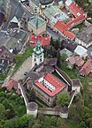
Aerial view of the old castle

Aerial view of the New Castle


There is an exhibition in the Glanzenberg gallery on Kammerhofská street . Two kilometers from the city center is the open-air mining museum ( Banské múzeum v prírode in Slovak ), where trips to a medieval mine ( Štôlna Bartolomej show mine ) take place. A botanical garden, which was built in 1810 and expanded in 1838–61, is still in the city, an approx. 4 hectare green area with around 250 species of plants, including an American sequoia tree from 1877. East of the city is the Calvary (Banská Štiavnica) , a complex three churches, nineteen chapels and a group of figures on and under the mountain Ostrý vrch (German Scharffenberg), which was built in the period 1744–51 with a large contribution from Jesuits.
traffic
Banská Štiavnica is well connected to the road network: the state road 51 (formerly national road 525) connects the city with Hronská Dúbrava (connection to the expressway R1 , E 58 towards Zvolen) and Hontianske Nemce (connection to state road 66 , E 77 towards Budapest) . To the west there is also the national road 524 via Bátovce , with a connection to the city of Levice and a district road to Žarnovica , where there is also a connection to the R1.
The city is the terminus of the Hronská Dúbrava – Banská Štiavnica railway line and there are several public transport connections to the Hronská Dúbrava and Zvolen train stations.
The city operates a small public transport network and there are direct bus connections to Bratislava, Nitra, Levice, Žiar nad Hronom , Zvolen and Banská Bystrica.
Twin cities
-
 Soragna , Italy
 -
 Olsztynek , Poland
 -
 Ptuj , Slovenia
 -
 Hünenberg , Switzerland
 -
 Moravská Třebová , Czech Republic
 -
 Sopron , Hungary
sons and daughters of the town
Born in Schemnitz:
- Christoph Kirmeser (* around 1550), rector of the city and parish school in Neisse; Provost of the Augustinian Canons in Glatz and author of a collection of sermons
- David Samuel von Madai (1709–1780), medic and numismatist
- Jozef Karol Hell (1713–1789), mining engineer, inventor of a water pump
- Maximilian Hell (1720–1792), astronomer and Jesuit
- Joseph Franz von Jacquin (1766–1839), chemist and botanist
- Johann Joseph Rösler (1771–1813), composer
- Anton von Puchner (1779–1852), General
- Albin Körösi (1860–1936), Romance scholar, Hispanist, Catalanist, translator and literary scholar
- Felizian Josef Moczik (1861–1917), organist, choir director and painter
- Domokos Kosáry (1913–2007), historian
- Vladimír Bahna (1914–1977), film director and screenwriter
- Radko Stöckl (1924–1984), educator and politician (SPD), MdL
- Ľudovít Lačný (1926–2019), chess composer
- Anton Hykisch (* 1932), author and politician, member of the National Council
- Magda Vášáryová (* 1948), actress and politician, member of the National Council
- Adam Hudec (* 1949), musician and composer
- Jaroslav Paška (* 1954), politician, MEP
- Ulrika Babiaková (1976–2002), astronomer and asteroid discoverer
Trivia
The main belt asteroid (22185) was named Štiavnica after the birthplace of its discoverer Ulrika Babiaková .
See also
literature
- Josef Labuda: The genesis of the city of Banská Štiavnica / Schemnitz and its later contacts with Upper Saxony. In: Yves Hoffmann, Uwe Richter (ed.): The early history of Freiberg in a national comparison. Urban early history - mining - early house building. Mitteldeutscher Verlag, Halle / Saale 2013, ISBN 978-3-95462-132-3 , pp. 337-344.
- Marko Vincenc Lipold : The mining of Schemnitz in Hungary. In: Yearbook of the Imperial Geological Institute. Vol. 17, Vienna 1867, pp. 317–460, urn : nbn: de: bvb: 12-bsb10226096-4 ( online ; digitized ; PDF; 10.5 MB).
- Nicolaus Poda von Neuhaus: Brief description of the machines built during the mining of Schemnitz in Nieder-Hungarn […]. Walther, Prague 1771 ( digitized version ).
Web links
- The Calvary in Banská Štiavnica (German)
Individual evidence
- ^ Banská Štiavnica. In: slovniky.korpus.sk. Slovenské slovníky, accessed April 23, 2017.
- ↑ Banská Štiavnica - Pravek. In: banskastiavnica.sk, accessed May 17, 2011.
- ↑ a b c Banská Štiavnica - Stredovek. In: banskastiavnica.sk, accessed May 17, 2011.
- ↑ minerály a horniny Slovenska: Banská Štiavnica - história. In: mineraly.sk, accessed on May 17, 2011.
- ↑ Banská Štiavnica - světové dedičstvo. In: banskastiavnica.sk, accessed May 17, 2011.
- ↑ Banská Štiavnica - História baníctva od 17.storočia. In: banskastiavnica.sk, accessed May 17, 2011.
- ^ Resident in Banská Štiavnicas before the war: 118 (minus 14 multiple responses and 2 incorrect assignments [manual counting]). In: Yad Vashem : Central Database of the Names of Holocaust Victims (Beta), accessed April 22, 2017.
- ↑ Murdered in Banská Štiavnicas: 13. In: Yad Vashem: Central Database of the Names of Holocaust Victims (Beta), accessed on April 22, 2017.
- ↑ See the city portrait of the Reformation city of Banská Štiavnica. Gold and silver. In: reformation-cities.org/cities, accessed on June 26, 2018 (on the Reformation history of the city).
- ↑ 2011 census by ethnicity. In: statistics.sk, accessed on April 22, 2017 (PDF; 4.6 MB; English).
- ↑ 2011 census by denomination ( Memento from November 12, 2013 in the Internet Archive ) In: scitanie2011.sk, accessed on April 22, 2017 (English).
- ↑ Banská Štiavnica ( memento from July 20, 2012 in the web archive archive.today ). In: slovakia.travel, accessed on April 21, 2017 (German).
- ↑ a b Banská Štiavnica - Sights, natural and technical monuments. In: banskastiavnica.sk, accessed on April 21, 2017.
- ↑ Banské múzeum v prírode. In: muzeumbs.sk. Archived from the original on November 29, 2017 ; accessed on June 26, 2018 (Slovak, website of the operator).
- ↑ Promotion of sustainable tourism in Central and Eastern Europe: Tourism in Banská Štiavnica (Slovakia). Funded by the Federal Ministry for the Environment, Nature Conservation and Nuclear Safety. Duration: 2000–2004 ( memorial from February 25, 2008 in the Internet Archive ). In: oete.de, Ö.TE Ökologischer Tourismus in Europa e. V., accessed on July 19, 2017 ("The aim is to promote nature conservation in a region in an exemplary manner through sustainable and holistic tourism development." Also on: "Historical and cultural background", "Tourism development and nature conservation conflicts", description of the most important Areas).
- ^ Kalvária v Banskej Štiavnici. In: kalvaria.org, accessed April 22, 2017 (Slovak).
- ^ Traveling to and from Banská Štiavnica. In: banskastiavnica.org, accessed July 19, 2017.

Cultural heritage: Vlkolínec farming village (1993) | Levoča , Spišský hrad , Spišské Podhradie and the Church of the Holy Spirit in Žehra (1993) | Mining town of Banská Štiavnica (1993) | Historical center of Bardejov (2000) | Wooden churches in the Slovak part of the Carpathian Mountains (2008)
Natural heritage: caves in the Aggtelek and Slovak Karst (1995) | Primeval beech forests in the Carpathian Mountains (2007)