Ľubietová
| Ľubietová | ||
|---|---|---|
| coat of arms | map | |

|
|
|
| Basic data | ||
| State : | Slovakia | |
| Kraj : | Banskobystrický kraj | |
| Okres : | Banská Bystrica | |
| Region : | Horehrony | |
| Area : | 61.037 km² | |
| Residents : | 1,219 (Dec. 31, 2019) | |
| Population density : | 20 inhabitants per km² | |
| Height : | 491 m nm | |
| Postal code : | 976 55 | |
| Telephone code : | 0 48 | |
| Geographic location : | 48 ° 45 ′ N , 19 ° 22 ′ E | |
| License plate : | BB | |
| Kód obce : | 508748 | |
| structure | ||
| Community type : | local community | |
| Administration (as of November 2018) | ||
| Mayor : | Pavel Zajac | |
| Address: | Obecný úrad Ľubietová 1 97655 Ľubietová |
|
| Website: | www.lubietova.sk | |
| Statistics information on statistics.sk | ||
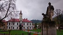
Ľubietová ( German Libethen , Hungarian Libetbánya ) is a municipality with around 1000 inhabitants in central Slovakia . It is located in the Zvolenská kotlina basin , on the edge of the Slovak Ore Mountains and the Poľana , about 20 km from Banská Bystrica and 30 km from Brezno . The geographical center of Slovakia, the Hrb mountain , is located near the place.

history
Thanks to the rich copper and small iron ore deposits , Ľubietová was a center of medieval mining. The place was first mentioned in writing in 1379 when it was elevated to the status of a Royal Free City. In 1388 it is mentioned under the name Lubeta . In the 16th century, the town was one of the founders of the Free Mining Cities (with Banská Bystrica , Kremnica , Banská Belá , Banská Štiavnica , Pukanec and Nová Baňa ). As a result of the decline of the mining industry in the 18th century, Ľubietová was downgraded from a royal free town to a simple village. The mineral libethenite , discovered in 1823, is named after the German name of the community.

