
Hronsek
| Hronsek | |||
|---|---|---|---|
| coat of arms | map | ||

|
|
||
| Basic data | |||
| State : | Slovakia | ||
| Kraj : | Banskobystrický kraj | ||
| Okres : | Banská Bystrica | ||
| Region : | Horehrony | ||
| Area : | 7.304 km² | ||
| Residents : | 654 (Dec. 31, 2019) | ||
| Population density : | 90 inhabitants per km² | ||
| Height : | 309 m nm | ||
| Postal code : | 976 31 ( Vlkanová post office ) | ||
| Telephone code : | 0 48 | ||
| Geographic location : | 48 ° 39 ' N , 19 ° 9' E | ||
| License plate : | BB | ||
| Kód obce : | 580236 | ||
| structure | |||
| Community type : | local community | ||
| Administration (as of November 2018) | |||
| Mayor : | Miroslav Ostrihoň | ||
| Address: | Obecný úrad Hronsek Záhumnie 26 97631 Vlkanová |
||
| Website: | www.hronsek.sk | ||
| Statistics information on statistics.sk | |||

Hronsek (until 1948 in Slovak "Garansek" - until 1927 "Hronsek-Skalka"; in Hungarian Garamszeg ) is a municipality in Slovakia near Banská Bystrica with a remarkable wooden articulated church .
The place appeared historically under different linguistic labels on (German gusset village , Garanseck , Hungarian Garamszeg , 1500 Zyklafalu , 1506 Czwiklafalwa , Czwiklina , 1514 Galowyczfalwa , 1515 Galowycz , 1522 Czwiklyna , 1558 Czwiklyna alias Galfalwa , 1565 Garanzegh , 1572 Czwklina ).
The village was first mentioned in 1500, but seems to date back to the 13th to 14th centuries. The noble families Prokop, Soos and from the 17th century the Géczy appeared as landlords.
The renaissance castle dating from 1576 (a castle of the Soos and Géczy families) and the mighty wooden articulated church from 1726, which has been on the UNESCO World Heritage List since 2008 , are to be mentioned as sights .
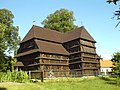
Articular church in the place

Castle in place

