Ilija (Slovakia)
| Ilija | ||
|---|---|---|
| coat of arms | map | |

|
|
|
| Basic data | ||
| State : | Slovakia | |
| Kraj : | Banskobystrický kraj | |
| Okres : | Banská Štiavnica | |
| Region : | Pohrony | |
| Area : | 10.633 km² | |
| Residents : | 358 (Dec. 31, 2019) | |
| Population density : | 34 inhabitants per km² | |
| Height : | 497 m nm | |
| Postal code : | 969 03 | |
| Telephone code : | 0 45 | |
| Geographic location : | 48 ° 25 ' N , 18 ° 54' E | |
| License plate : | BS | |
| Kód obce : | 516856 | |
| structure | ||
| Community type : | local community | |
| Structure of the municipality: | 1 village | |
| Administration (as of November 2018) | ||
| Mayor : | Vratislav Cengel | |
| Address: | Obecný úrad Ilija 150 96901 Banská Štiavnica |
|
| Website: | www.ilija.ocu.sk | |
| Statistics information on statistics.sk | ||
Ilija (German seldom Sankt Egidien , Hungarian Illés - until 1888 Illia ) is a municipality in central Slovakia .
It lies at the foot of the Štiavnica Mountains ( Štiavnické vrchy ) south of the city of Banská Štiavnica .
The municipal area was already settled in the Neolithic , the first written mention as Ecclesia Sancti Egidii is found in 1266, later the place is under the Latin name "Sanctus Egidius", the Hungarian name "Scenthegud" or "Zenth Egyed", a Hungarian-Slavic Variant "Zenthlyen" or the German name "Gilg" or "Gilgen" mentioned. Up until the 16th century the site of Sitno Castle was subject to tribute, in the 2nd half of the 16th century the place was visited by the Turks and temporarily occupied. After that it was owned by the Balassa family and from 1629 by the Koháry family . Until 1918 it belonged to the Kingdom of Hungary and was in Hont County .
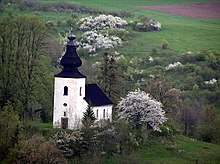
In the place is the Romanesque St. Aegidia Church ( Kostol svätého Egídia ) from 1254, the eponymous patron saint was St. Aegidius .

