Spišské Podhradie
| Spišské Podhradie | ||
|---|---|---|
| coat of arms | map | |

|
|
|
| Basic data | ||
| State : | Slovakia | |
| Kraj : | Prešovský kraj | |
| Okres : | Levoča | |
| Region : | Spiš | |
| Area : | 24.945 km² | |
| Residents : | 3,985 (Dec. 31, 2019) | |
| Population density : | 160 inhabitants per km² | |
| Height : | 430 m nm | |
| Postal code : | 053 04 | |
| Telephone code : | 0 53 | |
| Geographic location : | 49 ° 0 ′ N , 20 ° 45 ′ E | |
| License plate : | LE | |
| Kód obce : | 543578 | |
| structure | ||
| Community type : | city | |
| Urban area structure: | 2 districts | |
| Administration (as of November 2018) | ||
| Mayor : | Michal Kapusta | |
| Address: | Mestský úrad Spišské Podhradie Mariánske námestie 37 05304 Spišské Podhradie |
|
| Website: | www.spisskepodhradie.sk | |
| Statistics information on statistics.sk | ||
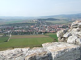
Spišské Podhradie (German Kirchdrauf , older also church village ; Hungarian Szepesváralja ; Polish Spiskie Podgrodzie ) is a small town in the north of Slovakia in the Spiš and directly below the Spiš castle of the same name.
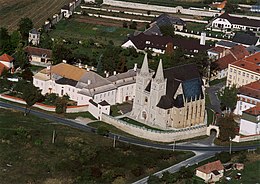
The Spiš Castle , the Spiš Chapter and Žehra are UNESCO World Heritage Sites . The city is the seat of the Roman Catholic diocese of Spiš , whose episcopal church is the Cathedral of St. Martin .
City structure
The city consists of 2 cadastral areas:
- Spišské Podhradie (German Kirchdrauf ) with the Spišská Kapitula district (incorporated in 1948; German Zipser Kapitel )
- Katúň (incorporated in 1991; German calico )
history
The place was mentioned in writing for the first time in 1249 and received city rights in 1412 . In the city is the former monastery of the Brothers of Mercy .
The Spišská Kapitula (German Zipser Kapitel , Hungarian Szepeshely ) has belonged to the place since 1948 . Once the seat of the Spiš provost and the diocese established in 1776, the place, walled between 1662 and 1665, was also the residence of the clergy's servants . The two-tower St. Martin's Cathedral, built in 1245, forms the center of the place, which was declared a city monument in 1950.
Population development
| Ethnic structure | ||||||||
|---|---|---|---|---|---|---|---|---|
| year | Residents | Slovaks | German | Hungary | Others | |||
| 1880 | 3,256 | 2.173 | 857 | 71 | - | |||
| 1910 | 3.129 | 1,832 | 713 | 566 | - | |||
| 2011 | 4,078 | 3,410 | - | - | - | |||
Culture
Surroundings

On the opposite side of the valley, in which the town of Kirchdrauf is located, lies the huge Spiš Castle ( Spišský hrad ).
The Dreveník travertine rocks , which were declared a national nature reserve in 1925 because of their uniqueness, are located in the vicinity of the town .
In the national nature reserve Sivá Brada ( Silberbart ) there is a weakly active cold water geyser below a hill with a baroque chapel. The water is lime and sulphurous and not particularly tasty.
The neighboring village of Žehra ( Schigra ) is one of the oldest Spiš communities. The church, built in 1245 with Gothic and Romanesque elements, has valuable frescoes inside .
Personalities
- Alfons Czibulka (1842–1894), military bandmaster and composer
- Kornel Schimpl (1907–1985), conductor, music teacher and composer
- Ján Šimbracký (around 1600–1657), organist and composer
- Johann Steller (1768–1857), Evangelical Lutheran theologian
See also
Web links
Individual evidence
- ^ Levoča, Spišský Hrad and the Associated Cultural Monuments. UNESCO Memory of the World, accessed September 1, 2017 .
- ↑ Národná Prírodná rezervácia Dreveník. Retrieved February 3, 2018 .
- ↑ Národná prírodná rezervácia Sivá Brada. Retrieved February 3, 2018 .
- ↑ Spišské Podhradie. Retrieved February 3, 2018 .
- ↑ Žehra. Retrieved February 3, 2018 .


