Nitra
| Nitra | ||
|---|---|---|
| coat of arms | map | |
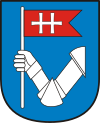
|
|
|
| Basic data | ||
| State : | Slovakia | |
| Kraj : | Nitriansky kraj | |
| Okres : | Nitra | |
| Region : | Nitra | |
| Area : | 100.479 km² | |
| Residents : | 76,533 (Dec. 31, 2019) | |
| Population density : | 762 inhabitants per km² | |
| Height : | 190 m nm | |
| Postal code : | 949 01 | |
| Telephone code : | 0 37 | |
| Geographic location : | 48 ° 19 ' N , 18 ° 5' E | |
| License plate : | NO | |
| Kód obce : | 500011 | |
| structure | ||
| Community type : | city | |
| Urban area structure: | 13 districts | |
| Administration (as of November 2018) | ||
| Mayor : | Marek Hattas | |
| Address: | Mestský úrad Nitra Štefániková 60 95006 Nitra |
|
| Website: | www.nitra.sk | |
| Statistics information on statistics.sk | ||
Nitra ( ; German Neutra , Hungarian Nyitra ) is a city in western Slovakia and with 76,533 inhabitants (as of December 31, 2019) the sixth largest city in the country after Bratislava , Košice , Prešov , Žilina and Banská Bystrica . Next to Bratislava, Nitra is the oldest Slovak city.
geography
location
The city is located in western Slovakia, about 90 km east of the capital Bratislava, on the river of the same name . It is the capital and the cultural and economic center of the Nitriansky kraj administrative district and the district of the same name , which is one of the most populous districts in Slovakia. Geomorphologically, the city belongs to the Slovakian Danube lowland , sub-part Nitrianska pahorkatina ( Neutra hill country ). The center of the village is at an altitude of 167 m. In the town itself there are some elevations such as the Castle Hill, the Gallows Hill ( Šibeničný vrch ), the Calvary Hill and the Katruša . The most important geographical feature, however, is the mountain Zobor ( 587 m nm ) in the north of the city, from which the Tribetz Mountains (Slov. Tribeč ) extend about 45 km to the northeast. The Zobor is accessible by hiking trails and offers an impressive view of Nitra and the meander of the river of the same name from its limestone cliffs . In the town the Dobrotka and Selenec brooks flow into the Nitra, from which the Malá Nitra arm branches off at Dolné Krškany. The lowest point of the city is at the height of 138 m nm. The size of the community area is about 100 km².
City structure
The city is divided into 13 districts:
|
In addition, the following communities were once districts of Nitra: Ivanka pri Nitre (1976–1992), Lužianky (1976–1993), Nitrianske Hrnčiarovce (1974–1990) and Štitáre (1975–2002).
Neighboring communities
The neighboring towns of Nitra are clockwise: Jelšovce and Podhorany the north, Nitrianske Hrnčiarovce in the Northeast, Malý Lapáš the east, Veľký Lapáš , Golianovo and (a square) Čechynce the southeast, Ivanka pri Nitre and Svätoplukovo in the south, Cabaj-Čápor and Jarok in the southwest, Lehota in the west and Lužianky , Zbehy and Čakajovce in the northwest.
climate
The following table shows the average climate values:
|
Average monthly temperatures and rainfall for Nitra
Source: Nitra climate data
|
||||||||||||||||||||||||||||||||||||||||||||||||||||||||||||||||||||||||||||||||||||||||||||||||||||||||||||||||||||||||||||||||||||||||||||||||||||||
history
From the first settlements to the first mention around 828
The area of Nitra was already relatively densely populated 30,000 years ago, the first arable farmers settled in the region 6,000 years ago. There are numerous finds from the Neolithic ( Band Ceramic Culture , Baden Culture ), Old and Young Bronze Ages ( Maďarovce Culture , Lusatian Culture ). In the 4th century BC The first people known by name can be identified as the Celts , who were talented metal foundries and iron smiths. These were at the end of the 2nd century BC. Pushed out of the region by the Dacians . Germanic finds are known from the early 1st century, namely the quadrupeds settled and the area bordered the kingdom of Vannius. A Roman camp from the 2nd century has not yet been proven, but there are also Roman finds in addition to Germanic ones. The Latin name of the city was Nitria .
The Slavs reached the area during the Great Migration Period towards the end of the 5th century. The Avar Empire reached the area in the 7th century, but further expansion to the north was prevented by an uprising led by the Franconian Samo . An intensive contact between Slavs and Avars has been proven by archaeological finds. After the fall of the Avar Empire at the end of the 8th century, the Slavs also established state structures. Nitra has been the seat of the Principality of Nitra since the end of the 8th century , which became part of Greater Moravia in 833 at the time of Prince Pribina , which was formed through the union with the Moravian Principality. The city was mentioned for the first time in 826 or 828 (see section names ) and here was the first known Christian church in Slovakia (828).
From the principality of Nitra after changing ownership to the Diocese of Neutra in the 12th century
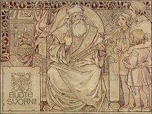
Even under Great Moravia, Nitra remained a prince's seat, the best-known prince is Svatopluk I , who was Neutra prince from the 850s to 871 and ruler of Great Moravia from 871–894. The diocese of Nitra was the first bishopric in Slovakia (880). During the reign of Svatopluk, Nitra reached its peak and consisted of five fortifications and about 20 settlements.
In the area of the city, the remains of several early Slavic settlements and grave finds from the 7th century were discovered. Individual finds from the 7th to 9th centuries also come from the nearby mountain Zobor .
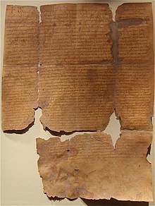
After a Hungarian attack, Great Moravia went under in 906 and the city had been under Hungarian rule from around 920. However, the city and its surroundings continued to maintain an autonomous status as a duchy in the emerging Hungarian state and was administered by members of the Árpáden . From 1001 to around 1018 the city was under Polish rule. The city's status as a duchy was definitively withdrawn in 1105, but it soon became the seat of the newly founded Diocese of Neutra and the seat of the County of Neutra . The Zobor documents from 1111 and 1113, the oldest documents still preserved in their original state in today's Slovakia , also come from this period .
Urban development from the 13th century
In 1241 the city granted protection to King Béla IV, who had been defeated in the Battle of Muhi (see Mongol Storm ), and also helped him with further escape. Subsequently, the Mongols could not conquer the city. In 1248 Béla IV made it a free royal city , but this only applied to the lower city. The upper town with the castle remained in the possession of the Neutra bishop. In 1271 and 1273 Nitra and the castle were conquered and sacked by an army of Přemysl Ottokar II . The bishop of Neutra received the lower town back in 1288, which subsequently became an agricultural provincial town. In the early 14th century, the city suffered severe damage under the rule of the oligarch Matthäus Csák . The first half of the 15th century was hardly peaceful either: during an uprising of the Hungarian nobility against Sigismund von Luxemburg , Neutra was conquered by Stibor von Stiborice in 1403 , and in 1431 she fell victim to the Hussites . In 1469 the monastery at Zobor, which had existed since the 11th century, was dissolved.
After the Hungarian defeat in the Battle of Mohács in 1526, Ottoman attacks could be expected. Guilds began to develop in the city from the mid-16th century. The Ottomans failed to attack the city in 1530 and during the second Turkish war , but they devastated the surrounding area. In the 17th century, in addition to the ever-existing Turkish threat, there were also uprisings against the Habsburgs: In 1605, Neutra was captured by Stephan Bocskai's rebels . At the end of 1621 it was badly damaged after a siege by Gábor Bethlen's army. In 1642 the Ottomans' third attempt to conquer the city also failed. In August 1663 they were able to occupy the city and Neutra became the seat of a sanjak within the Eyâlets Neuhäusel . In April 1664 the city was retaken by the imperial army. The last war event was for a long time the uprising of Francis II Rákóczi , because the rebels occupied the city in 1703 and the castle in 1704 and used it as a base for anti-Habsburg campaigns until 1708 . In 1710 400 people died of the plague .
New beginning after wars from the 18th century
Only after the Peace of Sathmar in 1711 could the destroyed city be rebuilt. This can still be seen today in a large number of baroque buildings . From the end of the 18th century, the city became one of the centers of the Slovak national movement . After the revolution of 1848/49 , the city achieved self-government for the first time since the Middle Ages and was no longer dependent on the diocese. Until 1877 the city was often divided into Upper and Lower Neutra. The city, which was previously characterized by agriculture and handicrafts, began to industrialize. By the First World War, a distillery, soap factory, machine factory, dairy and several other plants were established. The first railway out of Šurany opened in 1876 after there was a road to the nearest railway connection in Trnovec nad Váhom since 1850 . Later connections were established to Topoľčany , Hlohovec and Nové Zámky . The emerging Magyarization after the Austro-Hungarian Compromise had a particular effect in the city itself, as Neutra was the seat of Felsőmagyarországi Magyar Közművelődési Egyesület (FEMKE, German literally "Upper Hungarian Magyar Educational Association"), which was directed against Pan - Slavism , from 1883 to 1919 .
After the First World War, the city was occupied by the Czechoslovak troops on December 10, 1918 and thus part of Czechoslovakia (confirmed under international law by the Treaty of Trianon ). In 1928, after the abolition of Nitra County, the city lost the status of a county seat. In 1933, Nitra hosted the big national celebration Pribinove slávnosti on the 1100th anniversary of the consecration of the first church in Slovakia. After the establishment of the First Slovak Republic , Nitra once again became the seat of the Nitra County, but the development was limited by the border location with Hungary (see First Vienna Arbitration ). The strong Jewish community was almost completely wiped out by anti-Jewish laws and deportations to the German extermination camps. The city was captured by the Red Army on March 30, 1945 and annexed to Czechoslovakia.
Nitra after World War II and into the 21st century
After the February coup in the spring of 1948, there was a strong industrialization of the city and the construction of prefabricated districts around the city. At the same time, the city expanded to include surrounding communities, some of which became independent again after the Velvet Revolution . During the rule of the KSČ , the strong Catholic Church in the town was also suppressed. Church owned goods were nationalized and used for other purposes. In 1996 the city became the seat of the administrative region Nitriansky kraj in Slovakia, which has been independent again since 1993.
Surname
The first sources of evidence come from 826 ( Nitraua ), or 828 ( Nitrawa ) and 880 ( Nitra ). Both the German and Hungarian names are derived from the Slavic / Slovak name. There are several theories about the origin of the very old city and river name. The most common one says that the river name came first, in the form * Nitrahwa (Slov. Nitrava), which is derived from the Indo-European * envy (to flow) and the Germanic * ahwa (water, river, analogous to the Morava river ) developed. According to another popular view, the settlement name came first and this comes from the Slavic * neit- (ignite / hew, chop). In the second case, the name Nitra would mean something like “carved place” or “place where fires are lit”.
Residents
| Population development | |||
|---|---|---|---|
| year | Residents | year | Residents |
| 13th century | (2,000) | 1930 | 21,283 |
| 1752 | (2,000) | 1938 | 21,323 |
| 1820 | 3,900 | 1950 | 22,203 |
| 1848 | 9,483 | 1961 | 34,300 |
| 1869 | 10,700 | 1970 | 43,600 |
| 1890 | 13,538 | 1980 | 76,633 |
| 1910 | 16,400 | 1991 | 85,471 |
| 1921 | 19,107 | 2001 | 87,285 |
According to the 2011 census, 78,916 inhabitants lived in Nitra, of which 70,447 Slovaks , 1,443 Magyars , 521 Roma , 520 Czechs , 72 Moravians and Poles , 50 Russians , 46 Bulgarians , 42 Germans and 31 Russians . 5,330 residents did not provide any information on the ethnic group. All other residents belonged to an ethnic group with fewer than 20 members or to an ethnic group that was not listed separately in statistics. 52,136 residents supported the Roman Catholic Church , 2,042 residents the Evangelical Church AB , 329 residents the Greek Catholic Church , 245 residents the Congregational Church, 231 residents the Reformed Church, 164 residents the Orthodox Church , 118 residents the Jehovah's Witnesses, 77 residents to the Evangelical Methodist Church, 63 residents to the Old Catholic Church and 49 residents to the Apostolic Church. 14,390 inhabitants were without a denomination and the denomination was not determined for 5,330 inhabitants. All other residents confessed to a denomination with fewer than 40 members or to a denomination that was not listed separately in statistics.
According to the 2001 census, 95.42% of the 87,825 inhabitants were Slovaks. There were also 1.71% Hungarians, 0.92% Czechs and 0.37% Roma. According to denomination, the most widespread was the Roman Catholic Church with 74.22%, 17.22% described themselves as atheists, 4.15% of the residents gave no information and 2.84% were Protestant.
In the past the city housed large Hungarian and German populations, as well as a large German-speaking Jewish community. In 1891, already under strong Magyar state influence , there were 13,538 inhabitants: 5205 Slovak, 5002 Hungarian and 3234 German speakers, or 9538 Roman Catholic, 166 Evangelical Lutheran and 67 Evangelical Reformed Christians as well as 3757 inhabitants of the Jewish faith .
The Old Catholic Church of Slovakia is located in Nitra .
Cityscape
Most of the city's sights are concentrated in the old town ( Staré mesto ), consisting of the castle ( hrad ), the upper town ( horné mesto ) and the lower town ( dolné mesto ).
Nitra Castle
The Nitra Castle ( Nitriansky hrad ) with its nested churches, the bishop's seat and the surrounding fortifications with a single gate, is one of the most interesting building complexes in Slovakia. The castle complex, located high above a meander of the Nitra River, was probably built during the fall of Great Moravia. The castle got its current appearance in the 17th century. One of the main attractions is the Cathedral of St. Emmeram , which serves as the bishopric and actually consists of three different buildings: the Romanesque church of St. Emmeram from the 11th century, the Gothic lower church from the 14th century and the upper church from the 17th century. On the west side of the cathedral is the late Baroque bishop's palace, whose history goes back to the Middle Ages. The fortifications with five bastions date from the 16th and 17th centuries. Century when the castle had to be defended against both the Ottomans and insurgents.
Upper Town
The upper town is located immediately south of the castle around the Pribinovo námestie square , where a statue of Pribina can be found. The dominant feature of the square is the building of the Great Seminary ( veľký seminár ). The partly baroque (oriented towards the square) and partly neoclassical (towards the city) structure was built in the 18th century and still serves its purpose today. The neo-classical diocese library, which was completed in 1877 and contains around 66,000 volumes, also belongs to the building. In the corner of the classical palace for canons (1821) on the east side there is a statue of an atlantic, popularly known as “Corgoň”, a blacksmith who allegedly threw down large blocks of stone at the Turks during the Turkish attacks. Today the beer brand Corgoň is named after him . To the west of the square are the Franciscan monastery, built in the 17th century, and the Church of Saints Peter and Paul. One of the secular buildings is the county house at the lower end of the upper town. This building, originally built in the late Baroque style in 1777, was the first permanent seat of Nitra County. Today the house is designed in Secession style and houses the Nitrianska galéria , a regional gallery. Other sights are the classical building of the Small Seminary, some town houses and a statue of Saints Cyril and Methodius .
Lower town
The lower town , bounded by the streets Mostná , Palánok , Štúrova and the Nitra river, was a market town in contrast to the “church” upper town. It stretches on both sides of the street Štefániková trieda , with the large square Svätoplukovo námestie at the north end. There is the Divadlo Andreja Bagara (Andrej Bagar Theater) in the modern building that replaced the old county theater from 1883, which was built as a small copy of the Budapest National Theater and was destroyed by an aerial bomb in 1945. The neo-renaissance town house ( mestský dom ), completed in 1882, was actually the seat of the administration until 1990 and now houses a local history museum. In addition to numerous town houses, there is a synagogue from 1911 in the Moorish-Byzantine style in the lower town . Other noteworthy buildings are the building of the former Tatra Hotel, the Piarist monastery and church from the 18th century and the complex of the former monastery of the Vincentine Sisters.
More Attractions
On the north side of the castle, on the bank of the Nitra River, there is a city park with an outdoor swimming pool. In the city center, south of the lower town, you can see the building of the former barracks, which now houses the market hall. Further south is the 213 m-nm high Kalvarienberg .
The dominant feature of the Zobor district is undoubtedly the 578 m nm high mountain of the same name, which is a popular excursion destination. The chairlift leading to it has been out of service since 1994. On the foothill Pyramída 553 m nm stand next to the radio tower the base of the former Hungarian Millennium Monument from 1896, which was destroyed by the Czechoslovak legionnaires in 1921 . The famous monastery of St. Hippolytus was used by the Benedictines until 1468 . The Camaldolese were still active here in the 18th century . The extended building complex has been used by a sanatorium since 1953. About above is the nature reserve Zoborská lesostep with a small cave.
The attraction of the Dražovce district is the Romanesque church of Archangel Michael from the early 12th century on a hill above the district, an example of early medieval architecture.
Culture and sport
performing Arts
The most important theater in the city is the Divadlo Andreja Bagara (German Andrej Bagar Theater), which has been located in a modern building on Sventopluk Square since 1992, where the county theater was located until 1945. Since 1992 the theater has hosted the Divadelná Nitra festival in the last week of September . The second theater is called Staré divadlo Nitra (German Old Theater Nitra). It was originally a puppet theater, but is now geared towards the whole family.
Museums, galleries
The city is home to several museums: the Ponitrianske múzeum (German Museum of the Nitra region) is one of the local history museums and deals with regional biology, archeology, history and ethnography. Its predecessor was founded in 1896. The other museum is located southeast of the city center and is called Slovenské poľnohospodárske múzeum (German Slovak Agricultural Museum ). It was founded in 1960 and deals with the history of agriculture since prehistoric times, agricultural machinery, and the development of the food industry. The area also includes a museum railway , the Nitrianska poľná železnica , which was originally located around Želiezovce . The castle is the seat of the ecclesiastical diocesan museum.
Galleries in the city include the municipal Nitrianska galéria , Art Galéria, as well as a few other small galleries.
Sports
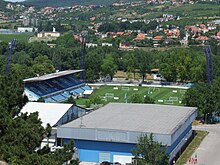
- Football - FC Nitra plays in the 2nd league , having played in the highest Corgoň league from 2005/06 to 2013/14 , and plays its home games at Štadión pod Zoborom . The best success so far is 3rd place in the 2007/08 season.
- Ice hockey - HK Nitra plays in the Slovak extra league . The team reached 2nd place in the final round of the 2013/14 season
- Basketball - BK SPU Nitra is one of the most successful teams in the Slovak basketball extra league.
Others
Every year at the beginning of July the city festival Nitra, milá Nitra takes place, named after the song of the same name from the 19th century.
economy
Due to the strong agriculture in the area, Nitra is mainly oriented towards the food industry and is considered the center of Slovak agriculture. Viticulture is also important, as is the machine and furniture industries. The Agrokomplex exhibition center southeast of the city center is also economically important .
The production of wiring harnesses for the automotive industry and credit cards for both Slovak and European banks is economically important in Nitra.
Sony opened a large-format LCD television production facility in October 2007, which was sold to Foxconn in 2010 . In 2018 Jaguar Land Rover opened a car factory in the city that initially employs 1,500 people.
science and education
Nitra is the seat of the Slovak Agricultural University and the Constantine Philosopher University . Also the Theological Institute of the Roman Catholic Theological Cyril and Methodius Faculty of the Comenius University in Bratislava has its place here.
traffic
Nitra is a junction of several high-level national roads. The following 1st-order streets cross or start in the city:
-
 Border CZ / SK near Holíč - Trnava - (interruption) - Nitra - Levice - Banská Štiavnica - Hronská Breznica
 -
 Border H / SK near Komárno - Nové Zámky - Nitra - Topoľčany - Prievidza - Žilina
-
 Nitra - Zlaté Moravce - Žiar nad Hronom - Martin
The R1 expressway runs to Trnava and thus also to Bratislava . On October 28, 2011, it was extended to the east to the existing sections in the Grantal , creating an efficient connection to Banská Bystrica . The remaining part in the north of the city serves as a feeder.
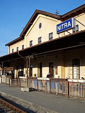
Rail traffic, on the other hand, is less important because the city is located off the main lines and is the last Slovak regional capital without an electrified railway line. The Nitra train station is located southwest of the city center on the Nové Zámky – Prievidza railway line . There are connections via local and regional trains to Bratislava, Komárno, Leopoldov , Nové Zámky, Prievidza, Šurany and Topoľčany. Smaller railway nodes are located north of the city in Lužianky and Zbehy, but some branch lines there are now without passenger traffic.
There is a small airfield in the Janíkovce district. The nearest international airport is Bratislava Airport , about 85 km away.
Local public transport is operated by the private operator Veolia Transport Nitra as and currently (as of June 2011) comprises 29 bus routes. In addition to the city itself , the network also includes the municipalities of Branč , Ivanka pri Nitre, Lužianky, Nitrianske Hrnčiarovce and Štitáre. With the exception of Branč, all municipalities were once part of Nitra.
sons and daughters of the town
- Stefan Schwartz (1851–1924), medalist in Vienna
- Wilhelm Viktor Krausz (1878–1959), painter
- Leopold Szondi (1893–1986), psychiatrist
- Vilmos Fraknói (1843–1924), historian
- Ernest Horniak (1907–1979), SDB , Catholic priest , youth minister , religious prisoner (sentenced to 12 years in prison).
- Anton Lehmden (1929–2018), painter and graphic artist
- Benjamin Z. Kedar (* 1938), Israeli historian
- Jan Ivan Lelley (* 1938), mycologist
- František Mikloško (* 1947), politician
- Jan Mojto (* 1948), media manager and film producer
- Peter Gajdoš (* 1959), politician
- Ľubomír Moravčík (* 1965), football player and coach
- Ľubomír Kolník (* 1968), ice hockey player
- Jozef Stümpel (* 1972), ice hockey player
- Dušan Milo (* 1973), ice hockey player
- Igor Demo (* 1975), football player
- Henrich Benčík (* 1978), football player
- Renáta Filová (* 1981), soccer player
- Monika Matysová (* 1981), soccer player
- Stanislav Hudec (* 1982), ice hockey player
- Stanislava Hrozenská (* 1982), tennis player
- Tomáš Kóňa (* 1984), football player
- Zuzana Štefečeková (* 1984), sports shooter
- Ivana Bojdová (* 1985), soccer player
- Štefan Ružička (* 1985), ice hockey player
- Alexandra Borbély (* 1986), actress
- Branislav Konrád (* 1987), ice hockey goalkeeper
- Anton Hruboň (* 1989), historian
- Monika Katonová (* 1989), soccer player
- Miroslav Stoch (* 1989), soccer player
- Augustín Bačinský (* 1949), Archbishop of the Old Catholic Church in Slovakia
Town twinning
-
 Backi Petrovac , Serbia
 -
 Budweis , Czech Republic
 -
 Gosford , Australia
 -
 Kroměříž , Czech Republic
 -
 Naperville , Illinois
 -
 Osijek , Croatia
 -
 Spišská Nová Ves , Slovakia
 -
 Zielona Góra , Poland
 -
 Zoetermeer , the Netherlands
See also
Web links
Individual evidence
- ↑ Ivan Lacika, Daniel Kollár: Nitra a okolie. Dajama, Bratislava 2003, ISBN 80-88975-53-0 , pp. 19-20.
- ↑ Nitra story
- ↑ Karol Pieta: hill settlements of the migration of peoples in the northern Carpathian basin. In: Heiko Steuer , Volker Bierbrauer (Ed.): Hill settlements between antiquity and the Middle Ages from the Ardennes to the Adriatic. With the assistance of Michael Hoeper. (= Reallexikon der Germanischen Altertumskunde. Supplementary volumes 58). de Gruyter, Berlin et al. 2008, ISBN 978-3-11-020235-9 , p. 472.
- ↑ Slovak history: chronology & lexicon - by Július Bartl, p. 23 (online)
- ↑ a b I. Lacika, D. Kollár: Nitra a okolie. 2003, p. 33.
- ↑ I. Lacika, D. Kollár: Nitra a okolie. 2003, pp. 39-40.
- ↑ Kováč, Dušan, "Kronika Slovenska 2", p. 194.
- ↑ I. Lacika, D. Kollár: Nitra a okolie. 2003, pp. 71-72.
- ↑ Nitriansky hrad (Slovak)
- ↑ I. Lacika, D. Kollár: Nitra a okolie. 2003, p. 21.
- ↑ Historical demographic data - populstat.info
- ↑ Ústredný portál verejnej správy - Nitra
- ↑ I. Lacika, D. Kollár: Nitra a okolie. 2003, pp. 41-43.
- ↑ 2011 census by ethnicity (Slovak) ( Memento from October 6, 2014 in the Internet Archive )
- ↑ 2011 census by denomination (Slovak) ( Memento from September 7, 2012 in the Internet Archive )
- ↑ I. Lacika, D. Kollár: Nitra a okolie. 2003, p. 51.
- ↑ Seminár (Veľký seminár) a Diecézna knižnica , nitra.sk, accessed on June 26, 2011
- ↑ Zoborský benediktínsky kláštor Sv. Hyppolita
- ↑ Kostol sv. Michala Archanjela , nitra.sk
- ↑ Múzeá v Nitre , Nitralive.sk
- ↑ Urban Audit - Nitra ( Memento of the original dated December 17, 2007 in the Internet Archive ) Info: The archive link was inserted automatically and has not yet been checked. Please check the original and archive link according to the instructions and then remove this notice.
- ↑ channelpartner.de: Sony confirms sale of European TV plant to Foxconn , April 1, 2010 (accessed November 22, 2018)
- ↑ Billion investment : Jaguar Land Rover opens car factory in Slovakia , October 25, 2018 (accessed November 22, 2018)
- ↑ PDF at www.zsr.sk ( Memento of the original from July 22, 2011 in the Internet Archive ) Info: The archive link was inserted automatically and has not yet been checked. Please check the original and archive link according to the instructions and then remove this notice.
- ↑ Map of the bus routes ( page no longer available , search in web archives ) Info: The link was automatically marked as defective. Please check the link according to the instructions and then remove this notice.
- ↑ KUBANOVIČ, Zlatko: Historický náhľad do dejín slovenských saleziánov (Od dona Bosca do roku 1924) . Bratislava: Don Bosco, 2019. ISBN 978-80-8074-436-6 . Pp. 243-244.


