Danube hill country
Coordinates: 48 ° 15 ′ 0 ″ N , 18 ° 15 ′ 0 ″ E

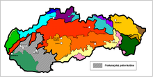
The Danube Hills ( Podunajská pahorkatina in Slovak ) is the north-eastern, more mountainous part of the Danube lowlands in Slovakia .
The area is located between the Danube Plain and the Danube in the south, the Little Carpathians in the west and the rest of the Western Carpathians in the north and east. The border to the Danube plain runs roughly along the line Bratislava - Senec - Sereď - Nové Zámky - Patince .
The soil consists of different types of rock ( clay , gravel , sand ), which are covered by Quaternary sediments such as loess and very fertile soils ( black and brown soils ).
The most important cities are Trnava , Topoľčany , Nitra , Levice , Dudince and Štúrovo .
The Danube hill country is divided into the following 11 geomorphological parts (divided from west to east) by the rivers Waag , Nitra , Žitava , Hron and Ipeľ :
- Trnavská pahorkatina (Tyrnau hill country)
- Dolnovážska niva (Lower Weighing Level )
- Nitrianska pahorkatina (Neutra hill country)
- Nitrianska niva (Neutra corridor)
- Žitavská pahorkatina (Žitava hill country)
- Žitavská niva (Žitava corridor)
- Hronská pahorkatina (Gran hill country)
- Hronská niva (Graner corridor)
- Čenkovská niva (Čenkov corridor)
- Ipeľská pahorkatina (Eipeler hill country)
- Ipeľská niva (Eipeler corridor)
The corridors mentioned have abundant underground water reservoirs, further water reservoirs also exist in the city of Dudince .
There are a number of small nature reserves in the area. For example, the wetlands in the Paríž moors ( Parížske močiare ) have been placed under protection. There are also different types of sandgrass or forest plains such as Čenkovská step or Chotínske piesky as well as many protected residues or still original oak forests (near Dubník or Vŕšok ).