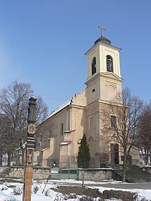
Kamenica nad Hronom
| Kamenica nad Hronom | ||
|---|---|---|
| coat of arms | map | |

|
|
|
| Basic data | ||
| State : | Slovakia | |
| Kraj : | Nitriansky kraj | |
| Okres : | Nové Zámky | |
| Region : | Podunajsko | |
| Area : | 18.714 km² | |
| Residents : | 1,314 (Dec. 31, 2019) | |
| Population density : | 70 inhabitants per km² | |
| Height : | 117 m nm | |
| Postal code : | 943 54 | |
| Telephone code : | 0 36 | |
| Geographic location : | 47 ° 50 ' N , 18 ° 44' E | |
| License plate : | NZ | |
| Kód obce : | 503231 | |
| structure | ||
| Community type : | local community | |
| Structure of the municipality: | 2 parts of the community | |
| Administration (as of November 2018) | ||
| Mayor : | Ján Elzer | |
| Address: | Obecný úrad Kamenica nad Hronom 106 943 54 Kamenica nad Hronom |
|
| Website: | www.kamenicanadhronom.sk | |
| Statistics information on statistics.sk | ||
Kamenica nad Hronom (until 1927 Slovak "Kevežd nad Hronom" or "Hronská Kamenica", Hungarian Garamkövesd ) is a municipality in the west of Slovakia , with a population of 1,314 (December 31, 2019) . It belongs to the Okres Nové Zámky , a district of the parent Nitriansky kraj . The population is predominantly Hungarian-speaking, there is also a Slovak minority.
geography
The community is located in the Danube Hills , part of the Slovak Danube lowlands at the foot of the Burda Mountains. It extends on the right bank of the Hron , just before the confluence with the Danube opposite the Hungarian city of Esztergom . These flows of Bajtava from Bach Bajtavský Potok in the Hron. The Kováčovské kopce-juh protected area extends in the Burda Mountains . Kamenica nad Hronom is five kilometers from Štúrovo .
Administratively, the municipality is divided into the municipality parts Kamenica nad Hronom and Kováčov (downstream to Chľaba ). The Bratislava – Budapest railway runs past the village .
history
The place was first mentioned in writing in 1320 as Kuesd and largely belonged to the estate of the Gran chapter. During the Turkish rule in the 15th and 16th centuries, the place slowly fell into disrepair. The population was employed in agriculture and viticulture.
Until 1919 the place in Hont County belonged to the Kingdom of Hungary and then came to Czechoslovakia . 1938-45 he was again part of Hungary due to the First Vienna Arbitration .


