Murska Sobota
|
Murska Sobota Olsnitz |
|||
|
|||
| Basic data | |||
|---|---|---|---|
| Country |
|
||
| Historic region | Übermurgebiet / Prekmurje | ||
| Statistical region | Pomurska (Mur region) | ||
| Coordinates | 46 ° 40 ' N , 16 ° 10' E | ||
| height | 190 m. i. J. | ||
| surface | 64.4 km² | ||
| Residents | 18,924 (January 1, 2016) | ||
| Population density | 294 inhabitants per km² | ||
| Telephone code | (+386) 2 | ||
| Post Code | 9000 | ||
| License Plate | MS | ||
| Structure and administration | |||
| Community type | City municipality (Austria) | ||
| Mayor : | Aleksander Jevšek | ||
| Mailing address | Kardoševa ulica 2 9000 Murska Sobota |
||
| Website | |||
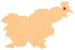
Murska Sobota ( German Olsnitz , Hungarian Muraszombat , Prekmurian : Mürska Subouta , Mürska Sobota ) is a small town and municipality in the extreme north-east of Slovenia , in the historical region of Prekmurje (Übermurgebiet). In 2006 the city was raised to the bishopric of the newly established diocese of Murska Sobota , which is a suffragan diocese of the Archdiocese of Maribor .
geography
location
Murska Sobota is located in Ravensko , the flat part of the historical Prekmurje region ( Übermurgebiet ) and is considered the main town. The city is also part of the Pomurska statistical region , which was introduced in May 2005 .
At the southern end, the Mur ( Slov .: Mura ) touches the municipality, immediately north of the city center, the second main river of the region flows past, the Ledava ( German : Limbach ). Because the Ledava repeatedly overflowed its banks in the past and caused massive flood damage in and around the city, it was dammed 13 km upstream to Ledavsko jezero .
The city is only around 15 km away from the borders with Austria and Hungary , and around 40 km from the next larger city, Maribor . There are no significant elevations, the municipal area is at 186–195 m. ü. A.
City structure
The municipality of Murska Sobota is divided into five districts ( Slov .: Mestne četrti , abbreviation: MČ ) and 11 local communities ( Slov .: Krajevne skupnosti , abbreviation: KS ). While the five districts together form the actual core city of Murska Sobota, the local communities each comprise exactly one town in the municipality. Unless otherwise stated, the exonyms in brackets are the Hungarian names of the villages. (Population figures as of January 1, 2016.):
|
City district ( Mestne četrti ):
|
Local communities ( Krajevne skupnosti ):
|
Neighboring communities
| Puconci | Moravske Toplice | |
| Tišina |

|
|
| Radenci , Križevci | Veržej | Beltinci |
population
The municipality of Murska Sobota ( Slov .: Mestna občina ) has 19,000, the city itself 11,000 inhabitants.
The population census in the municipality in 2002 showed the following nationality distribution: 94.9% Slovenian citizens, 2.0% Croatians , 1.0% EU citizens (then EU-15), 0.8% Yugoslavs (today: Serbs and Montenegrins ), 0.6% Bosnians , 0.3% Macedonians and 0.3% others.
The distribution of the population by language was as follows: 91.0% Slovene as their mother tongue , 2.3% Romani , 1.9% Croatian , 1.1% Hungarian and 2.1% other languages. The remaining 1.6% did not provide any information. The only official language is Slovenian.
history
Historically, the city has belonged to the Kingdom of Hungary since the Middle Ages . It appears early on under various names (such as Belmura (1297), Murazombatha (1348), Murazumbota (1366)), where "Mur" obviously refers to the river of the same name. Slovene “Sobota” and Hungarian “Szombat” mean Saturday. There are various explanations for this designation, such as the derivation from the usual market day or from a personal name. The German name of the city of Olsnitz is a Germanization of the old Slovenian name Olšnica . The modern Slovenian name is a translation of the Hungarian name Muraszombat . In the Treaty of Trianon from 1920, the city came to the newly founded Kingdom of Serbs, Croats and Slovenes (from 1929 to Yugoslavia ). After the Balkan campaign in the spring of 1941, the city became part of Hungary and after the end of the war in 1945 it came back to Yugoslavia. It has belonged to Slovenia since the fall of Yugoslavia .
Buildings and green spaces (selection)
- Castle complex ( Soboški Grad )
- Regional museum
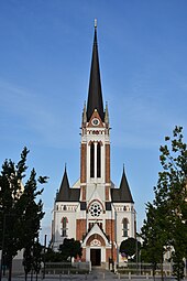
- St. Nicholas Cathedral
- ev. parish church
- Rakičan Palace ( Dvorec Rakičan )
- War Victims Monument
- Murska Sobota Gallery
- 5 exhibition pavilions ( Expano ) on the river bank in ultra-modern architecture
- Botanical Garden
Town twinning
Murska Sobota has partnerships with the German city of Ingolstadt in Bavaria (since 1979), with the US city of Bethlehem in the state of Pennsylvania, and with the Serbian city of Paraćin in the Pomoravlje district .
traffic
Murska Sobota is connected to the Slovenian motorway network by the A5 motorway, which runs directly through the municipality . It can be easily reached via the “Murska Sobota” and “Lipovci” junctions.
The municipality is located on the railway line from Ormož to Hodoš , which continues to Budapest . It is the only rail link between Slovenia and Hungary . There is a train station right in the city.
Murska Sobota also has a small sports airport.
Sons and daughters of the township
- Miki Muster (1925–2018), sculptor, draftsman and film director
- Ksenija Škrilec (* 1966), ambassador.
literature
- Muraszombat , in: Guy Miron (Ed.): The Yad Vashem encyclopedia of the ghettos during the Holocaust . Jerusalem: Yad Vashem, 2009 ISBN 978-965-308-345-5 , p. 505
Web links
- Official website of the city
- Information about Murska Sobota
- Map of the municipality of Murska Sobota
- Murska Sobota on 24cities.eu, Competence Center Steirisches Thermenland -Oststeiermark
Individual evidence
- ↑ Krajinski park Goričko (ed.): Značilnosti. Information board on the southeast bank of Ledavsko jezero .
- ↑ Joc Triglav: Vodna infrastruktura in zemliški cadastre. In: Geodetski vestnik 56/4 (2012), pp. 674-690. Online PDF , accessed on July 4, 2018 (Slovenian).
- ↑ SI STAT
- ↑ Statistical Office of the Republic of Slovenia (English)
- ↑ a b c d Viktor Lumtzer, Johann Melich: German place names and loan words of the Hungarian vocabulary. Sources and research on the history, literature and language of Austria and its crown lands ; Publishing house of the Wagner University Bookstore Innsbruck, 1900.
- ↑ The other 2.1% were divided into: 0.4% Serbian , 0.4% Serbo-Croatian , 0.3% Albanian , 0.2% Bosnian , 0.1% German , 0.1% Italian , 0.1 % Macedonian , 0.6% other. www.stat.si. Retrieved February 3, 2011 .
- ↑ The best sights in Murska Sobota. Tripadvisor.de, accessed January 12, 2020 .


