Šalovci
|
Šalovci Sal |
|||
|
|||
| Basic data | |||
|---|---|---|---|
| Country |
|
||
| Historic region | Übermurgebiet / Prekmurje | ||
| Statistical region | Pomurska (Mur region) | ||
| Coordinates | 46 ° 50 ' N , 16 ° 18' E | ||
| surface | 58.2 km² | ||
| Residents | 1,672 (2008) | ||
| Population density | 29 inhabitants per km² | ||
| Post Code | 9204 | ||
| License Plate | MS | ||
| Structure and administration | |||
| Mayor : | Iztok Fartek | ||
| Website | |||
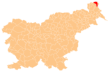
Šalovci ( Hungarian Sal , German Schlabing ) is a municipality and a village in Goričko , the hilly part of the historical Prekmurje region in Slovenia .
geography
The municipality occupies the north-eastern part of the Goričko hill and ditch country. The area of the entire municipality of Šalovci extends over an area of 58.2 km² and borders in the north and south-east on Vas / Eisenburg County in Hungary , as well as on the neighboring Slovenian municipalities of Hodoš in the east, Moravske Toplice in the south and Gornji Petrovci in the west.
The municipal area includes the headwaters of the river Kerka (Velika Krka) and the brooks Markovski potok, Budinski potok and Dolenski potok up to the watershed of Mur and Raab . In addition, the municipality is still traversed by the waters Adrijanski potok, Peskovski potok and Mala Kerka in a west-east direction. The heights above the sea of the individual lowlands and streams are on average 250 m. Distinctive high points of mountain tops and hills are: Stroski vrh (375 m), Veliki breg (Köles-hegy, 378 m), Gorički breg (362 m), Bejčin breg (333 m) in the north, and Šintarski breg (338 m), Novi vrh (326 m) in the south of the municipality. The entire municipality belongs to the three-country park Raab-Goričko-Örseg .
Places and inhabitants
The municipality had 1672 inhabitants in 2008 and consists of six localities. 462 people live in Šalovci itself. The official Hungarian exonyms from 1890 are given in brackets after today's place names .
- Budinci (Bűdfalva)
- Čepinci (Hungarian Kerkafő, German Spitzberg)
- Dolenci (Hungarian Dolány, German Dolinz) consisting of the districts (Hungarian Kisdolány, German Klein Dolinz) and (Hungarian Nagydolány, German Groß Dolinz)
- Domanjševci (Hungarian Domonkosfa, German Saint Domenicus)
- Markovci (Morocco)
- Šalovci (Hungarian Sal, German Schlabing)
traffic
Šalovci lies on the Zalalövő – Murska Sobota railway line .
literature
- Ivan Zelko , Historična Topografija Slovenije I. Prekmurje do leta 1500. Murska Sobota, 1982.
- Matija Slavič, Naše Prekmurje. Murska Sobota, 1999.
- Atlas Slovenije, Ljubljana 1985.
Web links
- Geopedia.si, map: Šalovci municipality
- Geopedia.si, map: place Šalovci
- Website of the municipality in Slovenian
Individual evidence
- ↑ Lumtzer, Viktor / Melich, Johann; German place names and loan words from the Hungarian vocabulary. Sources and research on the history, literature and language of Austria and its crown lands; Publishing house of the Wagner University Bookstore Innsbruck, 1900.
- ↑ Lumtzer, Viktor / Melich, Johann; German place names and loan words from the Hungarian vocabulary. Sources and research on the history, literature and language of Austria and its crown lands; Publishing house of the Wagner University Bookstore Innsbruck, 1900.


