
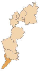
Jennersdorf district
| location | |
|---|---|
  |
|
| Basic data | |
| state | Burgenland |
| NUTS III region | AT-113 |
| Administrative headquarters | Jennersdorf |
| surface | 253 km² |
| Residents | 17.097 (January 1, 2020) |
| Population density | 68 inhabitants / km² |
| License Plate | JE |
| District Commission | |
| District Captain | Hermann Prem |
| website | Bra Jennersdorf |
| map | |
  |
|
The District Jennersdorf ( Hungarian Gyanafalvi járás ) is a political district of the castle country .
geography
The Jennersdorf district is the southernmost district in Burgenland. It borders Hungary to the east and Slovenia to the south . The landscape is shaped by the valleys of the Raab and its left tributary, the Lafnitz , both of which cross the district from west to east. The highest point is the Stadelberg on the Slovenian border at 417 m above sea level. A.
The district covers 253.2 km² and measures around 45 km from north to south and around 10 km at its widest point from west to east.
| Hartberg-Fürstenfeld | Gussing | Gussing |
.svg)
|
Vas (Hungary) | |
| Southeast Styria | Slovenia | Vas (Hungary) |
Administrative division
The Jennersdorf district consists of a total of twelve communities, including a town and seven market communities.

| local community | Hungarian | Croatian | location | Ew | km² | Ew / km² | Judicial district | region | Type
|
photo | Metadata |
|---|---|---|---|---|---|---|---|---|---|---|---|
German Kaltenbrunn
|
Némethidegkút |

|
1,734 | 24.18 | 72 | Gussing | market community
|

|
Acc. To code: 10501 |
||
Eltendorf
|
Ókörtvélyes |

|
920 | 20.57 | 45 | Gussing | local community
|

|
Acc. To code: 10502 |
||
Heiligenkreuz in the Lafnitz valley
|
Rábakeresztúr |

|
1,234 | 23.77 | 52 | Gussing | market community
|

|
According to code: 10503 |
||
Jennersdorf
|
Gyanafalva |

|
4.111 | 37.9 | 108 | Gussing | urban community
|

|
Acc. To code: 10504 |
||
Königsdorf
|
Királyfalva |

|
741 | 15.66 | 47 | Gussing | local community
|

|
According to code: 10511 |
||
Minihof-Liebau
|
Liba |

|
1,047 | 16.26 | 64 | Gussing | market community
|

|
According to code: 10505 |
||
Mogersdorf
|
Nagyfalva |

|
1,149 | 12.76 | 90 | Gussing | market community
|

|
According to code: 10506 |
||
Mill moat
|
Malomgödör |

|
384 | 5.54 | 69 | Gussing | local community
|

|
According to code: 10512 |
||
Neuhaus am Klausenbach
|
Vasdobra |

|
898 | 19.98 | 45 | Gussing | market community
|

|
Acc. To code: 10507 |
||
Rudersdorf
|
Radafalva |

|
2.172 | 21.42 | 101 | Gussing | market community
|

|
Acc. To code: 10508 |
||
Sankt Martin an der Raab
|
Szent Marton | Sveti Martin |

|
1.995 | 42.98 | 46 | Gussing | market community
|

|
According to code: 10509 |
|
Vistula tree
|
Badafalva |

|
712 | 12.17 | 59 | Gussing | local community
|

|
According to code: 10510 |
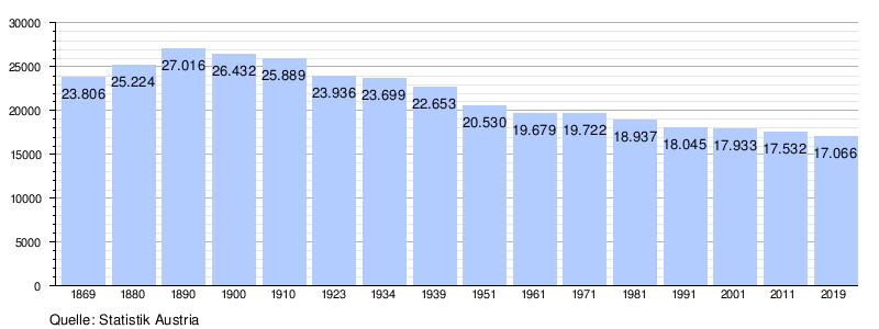
Population development
traffic
Street
The Güssinger Straße B 57 connects Raabtal and Lafnitztal and continues into the Stremtal to Güssing . The Gleisdorfer Straße B 65 leads from the Hungarian border in Lafnitztal in an east-west direction to Fürstenfeld and on to Graz . The extreme north can be reached via Stegersbacher Straße B 57a, while the extreme south is served by Doiber Straße B 58 from Jennersdorf to the Slovenian border.
A motorway is not in the district area. The closest autobahn is the A 2 south autobahn from Graz to Vienna , which can be reached via the Ilz-Fürstenfeld junction (138).
train
The Styrian Eastern Railway from Graz to Szombathely runs through the district area in a west-east direction . The Jennersdorf and Mogersdorf train stations are located in the district , the intervening stop in Weichselbaum an der Raab has been closed.
Special communities
The northernmost municipality is Deutsch Kaltenbrunn , the southernmost and westernmost municipality is Neuhaus am Klausenbach . The furthest to the east is Heiligenkreuz in the Lafnitz valley on the Hungarian border.
The smallest municipality is Mühlgraben with around 5.50 km², while Sankt Martin an der Raab is the largest with around 43 km².
Mühlgraben has the fewest inhabitants (384), the city of Jennersdorf has the most inhabitants with 4111 inhabitants (as of January 1, 2020).
Web links
- Jennersdorf district on burgenland.at
Eisenstadt | Eisenstadt area | Güssing | Jennersdorf | Mattersburg | Neusiedl am See | Oberpullendorf | Oberwart | Rust
Coordinates: 46 ° 56 ' N , 16 ° 8' E