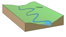
Valley path
The word valley path denotes the line connecting the lowest points of all cross sections in the longitudinal direction of a river , stream, canal or valley . In water-free valleys it is identical to the “water collection line”; there paths often follow his line.
The position of this line is constantly changing where it runs in bodies of water, since changing water levels , flow speeds and sediment shifts shift and deform the river bed and thus also change the valley path. (See also: meandering .) The valley path shuttles between the bank lines of the water, it is usually neither below the center line of the flowing water nor below the stream line , which is defined as the line connecting the points with the highest flow speed and - when there is no wind - already at little runs under the surface. Depending on the runoff behavior and the bed of the river , the valley path does not even have to run in the widest part of ramified watercourses with river islands between individual river arms, as the current may have buried the river bed deeper in a narrower arm .
The location of the valley path is determined by sounding ( bearing ) and shown in survey logs and large-scale maps .
Sometimes border courses follow, for example between countries, the valley path of a border river.
See also
- In a 1975 treaty, the valley path was established as the Iraqi-Iranian border in the Shatt al-Arab river . The termination of the treaty by Saddam Hussein and his demand to redefine the east bank as the border was one of the triggers of the Iran-Iraq war .
- Valley floor , longitudinal valley
- Borderline
