Kallabak
| Kallabak / Kallabaku | ||
|---|---|---|
|
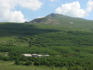
View from the north of the mountain |
||
| height | 2171 m | |
| location |
|
|
| Mountains | Šar Planina | |
| Dominance | 8.4 km → Maja Kulla e Zyberit | |
| Notch height | 321 m ↓ Juriško Groblje | |
| Coordinates | 41 ° 55 '5 " N , 20 ° 34' 34" E | |
|
|
||
| Normal way | Mountain hike from Shishtavec (Albania) | |
|
Shishtavec highlands with the Kallabak in the background |
||
The Kallabak ( Albanian Kallabaku or Maja e Kallabakut ) is a mountain in the Sharr Mountains on the Albanian - Kosovar border. With a height of 2171 m above sea level. A. on Albanian maps or 2174 m. i. J. In other sources, the Kallabak is one of the highest peaks between the range of the Šar Planina in the southeast, the Korab Mountains ( 2764 m above sea level ) in the south, the Gjallica ( 2485 m above sea level ) in the northwest and the Koritnik ( 2393 m above sea level ).
The Kallabak is seven kilometers south of the village of Shishtavec in the Gora region . Kukës is around 20 kilometers air distance to the northwest. Not quite five kilometers south of the Kallabaks is the triangle between Albania, Kosovo and North Macedonia on the Maja Kësula e Priftit ( 2093 m above sea level ) .
The summit rises around 200 meters from the long ridge between the catchment areas of the Luma in the north and the Çaja in the south. It is the main ridge of the Pllaja e Shishtavecit, a mountain range 15 kilometers long and up to eleven kilometers wide. Both are tributaries of the Drin , which have cut through narrow gorges to this one path. The next peak on the ridge in the southwest, about three kilometers away, is the Maja e Kallabakut vogël ( 2210 m above sea level ), the "Little Kallabak". The area around the Kallabak is treeless grassland that stretches up to the summit. In the northeast, the mountain falls rocky around 200 meters into a cirque , which gives it a distinctive shape. On the north slope between 1650 m above sea level. A. and 1800 m above sea level A. was during communism in several places quartz mined.
The Albanian side of the mountain belongs to the Korab-Koritnik nature reserve , the Kosovar to the Sharr National Park . About three kilometers north of the mountain there is a small lake that, together with the adjacent birch forest Mështekna e Shishtavecit, has been protected as a national natural monument since 2002 . To the west of this is the hamlet of Turaj (approx. 1500 m above sea level ). Around Turaj, simple accommodation is offered in some houses and alpine huts.
Web links
Individual evidence
- ↑ Official map 1: 50,000 of the military cartographic office of Albania, sheet K-34-78-A Shishtavec , 2nd edition 1985
- ↑ a b Kuvendi i Republikës së Kosovës: Ligji No. 04 / L - 087 për Parkun Kombëtar Sharri . December 13, 2012, p. 2 ( kuvendikosoves.org [PDF; accessed March 16, 2019]).
- ↑ a b Akademia e Shkencave e RPSSH (ed.): Gjeografia fizike e Shqipërisë . tape 2 : Vështrim fiziko-gjeografik krahinor. Tirana 1991, p. 122-124 .
- ↑ Natyror Korab-Kortnik Park. In: Agjencia Kombëtare e Zonave të Mbrojtura. Retrieved March 16, 2019 (Albanian).
- ↑ Site factsheet for Mështekna e Shishtavecit (liqeni i Kallabakut). In: EUNIS. European Environment Agency (EEA), accessed on March 16, 2019 .
- ↑ Mali i Kallabakut. In: Palm Tree Productions. May 2014, accessed on May 16, 2019 .


