Inside
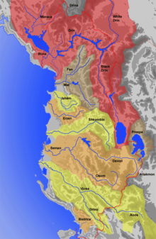
The Drin ( Albanian also Drini , Macedonian and Serbian Дрим Drim , Latin Drilon ) is a river in the southwest of the Balkan Peninsula with a length of 285 kilometers. The average amount of water is 352 m³ / s. It drains an area of 19,686 km², which includes large parts of northern and eastern Albania , areas in the west and south-west of North Macedonia , the western part of Kosovo and the south-east of Montenegro . The Drin arises in the north-east Banan town of Kukës from the Black and White Drin, the sources of which are in North Macedonia and Kosovo.
The inside is repeatedly dammed to generate energy.
Black inside
The Black Drin (Alb. Drin / -ii Zi ; Macedonian Црни Дрим Crni Drim ) rises from Lake Ohrid . The southwest Macedonian town of Struga is located at the outflow at 695 m . The river flows 149 kilometers northwards through the mountainous landscape of western Macedonia and northeastern Albania.
In North Macedonia, the river passes two reservoirs, Lake Globočica and Lake Debar, directly at Debar . Shortly after the large dam of Lake Debar, it reaches the border with Albania, which it forms for a few kilometers. After that, he went over entirely to Albanian territory. The further course of the river in Albania stretches north through poorly populated, mountainous and impassable landscapes.
White in there
The White Drin (Alb. Drin / -ii Bardhë ; Serbian Beli Drim Бели Дрим ) rises near the village of Radac / Radavac north of Peja from a strong mountain spring . For the first 25 kilometers it runs as a partly strongly meandering plain river in an easterly direction, before turning south just before the town of Klina . Six kilometers below the village, the Pećka Bistrica (alb. Lumbardh / -ii Pejës ) joins from the right . The White Drin drains the Dukagjin plain or Metochien (Alb. Rrafsh / -ii Dukagjinit ; Serb. Metohija / Метохија). Its course leads from Klina primarily to the south, where it initially flows in a narrow valley through the western foothills of the Crnoljeva Mountains (Alb. Carraleva ). After re-entering the plain, the Drin takes up the Lumbardh i Deçanit (Serbian Dečanska Bistrica ) coming from the right and the Erenik a few kilometers further and passes the Drin Gorge .
On the last 20 kilometers of its course in Kosovo - from around the town of Krajk - the White Drin sometimes flows through narrow gorges and is already subject to the influence of the Fierza Dam , which is located in neighboring Albania. Here it takes its last major tributary from the left, the Prizrenska Bistrica (Alb. Lumbardh / -ii Prizrenit ).
With about 113 kilometers on Kosovar territory, it is the longest river in the country. To the west of the city of Prizren , it crosses the border to Albania - already dammed up to Lake Fierza - where it joins the Black Drin after 16 kilometers. Shortly before, the Luma joins from the south .
United inside
In the north-eastern town of Kukës , the white people coming from the northeast and the black people coming from the south unite. The course of the river is dammed almost without exception in the Northern Albanian Alps , which are crossed westwards. Both upper reaches feed the Fierza reservoir (alb. Liqen / -ii Fierzës ), which dams the White Drin up to the border to Kosovo, is around 72.5 square kilometers and up to 128 meters deep. The following Koman reservoir (alb. Liqen / -ii Komanit ) also serves as a traffic route in the remote mountain region. In addition to a passenger ferry that serves the small hamlets along the lake, two car ferries operate between the Fierza and Koman landing stages in summer (as of June 2015). Lake Koman is around twelve square kilometers and has a maximum depth of 96 meters. The dam of Vau-Deja , which forms the Vau-Deja reservoir (alb. Liqen / -ii Vaut të Dejës ), is located on the western edge of the mountains. The last reservoir has an area of 24.7 square kilometers and is up to 52 meters deep.
The Fierza reservoir is also fed by the Valbona tributary , the Koman reservoir by the Shala .
Underflows

Shortly after the dam, the Drin in the coastal plain of Northern Albania is separated by a bifurcation . Subsidence or floods in the years 1858/59 meant that the majority of the water masses looked for a new path, which probably corresponds to the course in antiquity to some extent.
The Old Drin (alb. Drin / -ii Lezhës ), a very small arm of the river, which today is mainly fed by the Gjadër tributary , stretches south through the Zadrima plain. This used to be the only run. A little west of the city of Lezha , where it cuts a path between two hills, it reaches the Adriatic Sea in the Drin Gulf . It has formed a large lagoon system in the flat coastal plain. The main lagoon north of the Drins is called Kuna , the one south is called Vain .
The second, larger arm of the river (therefore also called Großer Drin , alb. Drin / -ii Madh ) runs to the west. The Ashta hydropower plant on the United Drin, which opened in 2012 , is located a little below the Vau-Deja reservoir and will be passed first. Then the Drin passes the southern edge of the city of Shkodra , where it unites not far from Rozafa Castle near Bahçallëk with the Buna (Serbian Bojana / Бојана) who has just left Lake Shkodra . The Buna, which forms the border between Albania and Montenegro for more than half of the route , reaches the Adriatic after 32 kilometers. The mouth is located around 20 kilometers northwest of the mouth of the southern Drin arm, also on the Drin Gulf . In contrast to the Drin, the Buna is navigable throughout.
literature
- Karl Karohl: Through Albania's Gorges - A contemplative folding boat ride across the land of the Schkipetaren and a brief history of the country. Brücke-Verlag Kurt Schmersow, Kirchhain 1939.
- International Network of Water-Environment Centers for the Balkans (INWEB): Drin / Drim River Sub-basin.
Web links
Individual evidence
- ↑ Information on the source and source height of the Black Drin
- ↑ Information on the mouth and mouth height of the Großer Drin
- ↑ a b Albanian rivers. In: Bora Property Albania. Retrieved May 16, 2014 (Albanian).
- ↑ a b Elisabeta Poci: Hydrology of the transboundary Drin River Basin . University of Texas at Austin 2011 ( balwois.com [PDF; 4.5 MB ; accessed on May 16, 2014]).
- ^ Journey to Valbona: How to get there. Accessed April 7, 2018 .
- ↑ Karl Reddemann: On the history of the cities of Shkodër, Durrës, Tirana, Gjirokastër and Elbasan . In: Cay Lienau, Günter Prinzing (Ed.): Albania - Contributions to geography and history. Publishing house Dr. Cay Lienau, Münster 1986, ISBN 3-9801245-0-9 .
- ↑ Niko Pano: Pasuritë ujore të Shqipërisë . Akademia e Shkencave e Shqipërisë , Tirana 2008, ISBN 978-99956-10-23-4 .
- ^ Volker Grundmann: Travel Guide Albania . Unterwegs Verlag, Singen 2010, ISBN 978-3-86112-274-6 .


