Koman reservoir
| Koman reservoir | |||||||
|---|---|---|---|---|---|---|---|
| Koman lake | |||||||
|
|||||||
|
|
|||||||
| Coordinates | 42 ° 6 '23 " N , 19 ° 49' 37" E | ||||||
| Data on the structure | |||||||
| Construction time: | 1979-1988 | ||||||
| Height above valley floor: | 115 m | ||||||
| Height above foundation level : | 133 m | ||||||
| Height above the river bed : | 96 m | ||||||
| Height of the structure crown: | 185 m | ||||||
| Building volume: | 600,000 m³ | ||||||
| Crown length: | 250 m | ||||||
| Power plant output: | 600 MW | ||||||
| Operator: | KESH | ||||||
| Data on the reservoir | |||||||
| Altitude (at congestion destination ) | 172 m | ||||||
| Water surface | 12 km² | ||||||
| Reservoir length | 34 km | ||||||
| Storage space | 430 000 000 m³ | ||||||
| Particularities: |
Ferry crosses the dammed lake lengthways through the Drin Gorge |
||||||
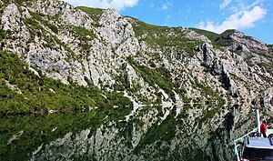
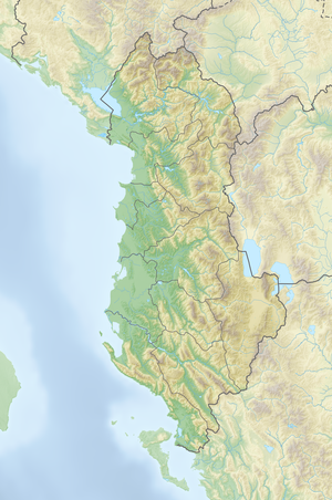
The Koman reservoir ( Albanian Liqeni i Komanit ) is a reservoir on the Drin in northern Albania . Built between 1980 and 1988 in the Malgun Gorge ( gryka e Malgunit ) near the village of Koman , the stone embankment with a concrete outer layer is 115 meters high, consists of 600,000 cubic meters of material and dams a lake of twelve square kilometers. The water level is 170 m above sea level. A.
The connected hydropower plant , originally named after Enver Hoxha , has four turbines from France and an output of 600 MW, which is said to have been the largest in Albania and in Southeast Europe at the time. Due to the scarcity of water, electricity production has had to be drastically cut back in recent years. The Koman reservoir next to the Drin is fed by the Valbona and the Shala .
The Koman Reservoir is up to 96 meters deep and part of a number of reservoirs along the Drins. The Koman reservoir extends as far as the dam of the Fierza reservoir ( Liqeni i Fierzës ), while the Liqen i Vaut të Dejës, dammed by the dam Vau-Deja, extends almost to the dam of the Koman reservoir. With around 500 million cubic meters, Lake Koman is the smallest reservoir in the cascade.
The Drin had cut deep gorges into the mountains of the Albanian Alps in the area of the Koman reservoir . The lake runs as a long tube over 34 kilometers through the narrow valley of the Drin and is hardly ever more than 400 meters wide. In the narrowest gorges, surrounded by cliffs hundreds of meters high, the lake is barely 50 meters wide.
A passenger ferry that also transports bicycles and motorbikes runs daily on the lake from Koman to Fierza or Breg-Lum. After the car ferry was shut down for financial reasons, two car ferries have been operating since spring 2015. The ferries open up the north-east of Albania with the city of Bajram Curr and the Tropoja region . The journey takes around two and a half hours and is also popular with tourists because of the passages between high rock walls through narrow gorges that are reminiscent of Norwegian fjords . Smaller boats bring people and goods to remote villages, which are often far away high above the lake, but can only be reached via the water.
See also
- List of the largest dams on earth
- List of the largest reservoirs on earth
- List of the largest hydroelectric plants in the world
- List of dams in the world
Web links
- Description of the system on the KESH website (Albanian)
- Drin River Hydropower Plants ( Memento from December 25, 2011 in the Internet Archive ) (PDF)
- Drive across the lake in time lapse on YouTube
Individual evidence
- ↑ a b Facts Rreth KESH. (Graphic) In: KESH. Retrieved February 1, 2016 (Albanian).
- ↑ Niko Pano: Pasuritë ujore të Shqipërisë . Akademia e Shkencave e Shqipërisë , Tirana 2008, ISBN 978-99956-10-23-4 .
- ↑ Instituti i Statistics : Tregues sipas qarqeve / Indicators by Prefectures 2005/06 , Tirana 2007 ( Memento from July 24, 2011 in the Internet Archive )
- ^ A b Norbert Stanek: On the electricity industry in Albania . In: Albanian notebooks . 15th year, no. 1 , 1986.
- ↑ a b Julie Briard: Le Petit Futé Albanie . Nouvelle Éditions de l'Université, Paris 2006, ISBN 978-2-7469-1761-3 .
- ^ Journey to Valbona: How to get there. Retrieved January 17, 2016 .
- ↑ The Albania Podcast. In: World Tour - The Travel Podcast. Retrieved March 20, 2019 .


