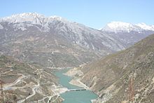
Fierza
Fierza ( Albanian also Fierzë ) is a place in northeastern Albania in the valley of the Drin . Fierza lies on both sides of the Drin, which forms the border between the municipalities of Fushë-Arrëz and Tropoja .
Before the territorial reform of 2015, there were both in the district of Puka , as in the district Tropoja a town named Fierza .
- The municipality of Fierza in the Puka district south of the river had 1302 inhabitants (2011) on an area of 81.19 square kilometers and consisted of the eight villages of Fierza, Poradha, Buxhan, Kokëdoda, Arst, Miliska, Mëz and Aprrip.
- The municipality of Fierza in the Tropoja district north of the river had 1607 inhabitants (2011; 2001: 2381 E.). In addition to the center (913 inhabitants), the municipality also included the villages Dega (387 inhabitants), T'plan (496 inhabitants), Dushaj (168 inhabitants) and Breg-Lumi (417 inhabitants).
Below Fierza, the Drin was dammed into Lake Koman in the 1980s and into Lake Fierza above in the 1970s . The Fierza Dam is the largest dam in Albania with a height of 152 meters . The power plant in Fierza is one of the country's most important electricity producers.
The Drin, which is dammed into lakes, does not only divide Fierza in two halves. Here, where the Valbona coming from the north joins, various traffic routes intersect. The most important is the Drin itself: a passenger ferry operates daily on Lake Koman . During the tourist summer season, two car ferries also run between Koman at the other end of the lake and Fierza or Breg-Lumi. The pier in Breg-Lumi is relocated depending on the water level of the lake and usually consists of a small concrete ramp on a flat, unpaved area. A road connects Fierza, where it crosses the Drin on a bridge, with Bajram Curr in the north, around 15 kilometers away, and Fushë-Arrëz in the south, which is difficult to reach due to the mountains . The ferry on Lake Fierza, which led to Kukës , was stopped in the 1990s.
Remains of Roman buildings and a Roman road have been found in Fierza .
New Catholic churches were built in Fierza-Puka and Breg-Lumi.
Web links
Individual evidence
- ↑ Ines Nurja: Censusi i popullsisë dhe banesave / Population and Housing Census - Shkodër 2011 . Results Kryesore / Main Results. Ed .: INSTAT . Pjesa / Part 1. Adel Print, Tirana 2013 ( instat.gov.al [PDF; accessed April 14, 2019]).
- ↑ Komuna Fierzë. (PDF; 132 kB) (No longer available online.) In: Keshilli i Qarkut Shkodër. Archived from the original on July 27, 2011 ; Retrieved November 7, 2010 (Albanian). Info: The archive link was inserted automatically and has not yet been checked. Please check the original and archive link according to the instructions and then remove this notice.
- ↑ Ines Nurja: Censusi i popullsisë dhe banesave / Population and Housing Census - Kukës 2011 . Results Kryesore / Main Results. Ed .: INSTAT . Pjesa / Part 1. Adel Print, Tirana 2013 ( instat.gov.al [PDF; accessed April 14, 2019]).
- ↑ Profile of Fierze commune. (PDF; 328 kB) In: UNDP's Local Governance Program. 2001, archived from the original on November 6, 2013 ; accessed on November 7, 2010 (English).
- ^ Journey to Valbona: How to get there. Retrieved January 23, 2016 .
- ↑ James Pettifer: Albania & Kosovo - Blue Guide . A & C Black, London 2001, ISBN 0-7136-5016-8 .
Coordinates: 42 ° 16 ' N , 20 ° 2' E

