
Vau Deja Reservoir
| Vau Deja Reservoir | |||||||
|---|---|---|---|---|---|---|---|
 |
|||||||
|
|||||||
|
|||||||
| Coordinates | 42 ° 0 '49 " N , 19 ° 38' 9" E | ||||||
| Data on the structure | |||||||
| Lock type: | 2 rock embankments, 1 earth dam | ||||||
| Construction time: | 1968-1973 | ||||||
| Height above valley floor: | 34 m | ||||||
| Height above foundation level : | 46.4 m | ||||||
| Height above the river bed : | 52 m | ||||||
| Height of the structure crown: | 79 m | ||||||
| Crown length: | 380 m, 375 m, 240 m | ||||||
| Power plant output: | 250 MW | ||||||
| Operator: | KESH | ||||||
| Data on the reservoir | |||||||
| Altitude (at congestion destination ) | 76 m | ||||||
| Water surface | 24.7 km² | ||||||
| Reservoir length | 20 km | ||||||
| Storage space | 319 000 000 m³ | ||||||
| Particularities: |
3 dams; |
||||||
 |
|||||||

The Vau Deja Reservoir ( Albanian Liqeni i Vaut të Dejës ) is the lowest reservoir in a series of three large hydropower plants on the Drin in northern Albania . Construction of the three dams began in the 1960s. The hydropower plant was built between 1971 and 1973 and was put into operation in 1973. Chinese help planned and built . The output of the five turbines is around 250 MW . The water level is 74 m above sea level. A. Height, the maximum depth of the body of water is 52 meters, the capacity is 319 million cubic meters, according to other sources 680 million cubic meters.
.jpg)
The Vau Deja Reservoir is part of a series of hydropower plants along the Drin River. A little above the Koman reservoir connects , which is immediately followed by the Fierza reservoir . At Vau-Deja , the water from the Drin is channeled into the Spathara reservoir just below the dams , which is used to generate energy at the Ashta hydropower station . The three old plants in Koman , Fierza and Vau-Deja have been renewed in recent years with foreign help in order to better secure the electricity production that is important for Albania.
The banks of the Vau-Deja reservoir are shaped by a bank course characterized by many small bays. The lake consists of several basins that are connected by canals. A first basin of around 4 square kilometers, called Gjiri i Gomsiqes , lies east of the main course just behind the dam. The main course, around 500 meters wide, ends around 5 kilometers after the dam in the central basin, which is around eight square kilometers in size. In this central part is also the small island Shurdhahi, in antiquity a castle hill on the Drin, which the Illyrians and Romans had fortified as part of the Roman province of Dalmatia Superior and which developed into the small town of Sarda , a bishopric in the Middle Ages . In the years 1967 to 1972 the whole area of Sarda was archaeologically examined, since the dammed lake buried a considerable part of the former settlements under itself. Behind this basin, the lake in the Drin valley narrows until it soon resembles a river. A few kilometers before Koman there is another small basin, where the lake widens again to almost a kilometer.
The river Drin was dammed at Vau-Deja , where it emerges from the northern Albanian mountains into the coastal plain. A total of three dams had to be built to close various cuts in the coastal rim.
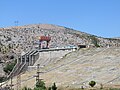
- The Qyrsaq dam is located at Laç-Qyrsaq, the center of Vau-Deja. The 375 meter long stone embankment dam is 46 meters above the foundation level and a visible height of 44 meters. The power house is located below the dam . On the north side there are 3 overflow gates for flood relief .
- The Zadeja Dam is about half a kilometer to the northwest. It closes the main valley of the Drin. The rock embankment dam is 380 meters long. The crown is 59.5 meters above the foundation level and 59 meters above the valley floor. The dam has two flood relief tunnels.
- The Rragam Dam is five kilometers further north by the village of Rragam in the east of Shkodra . It is a 240 meter long, curved earth dam. The dam reaches a height of 21 meters above the foundation level and 18 meters above the valley floor. Originally the Rragam dam was also provided with an overflow. Since the construction of the Fierza reservoir, however , the risk of flooding has decreased and the overflow has been removed.
Qyrsaq Dam

Zadeja dam behind Spathara reservoir


Older maps show various villages in the flooded river valley. The area around the Vau-Deja reservoir, on the other hand, has only been sparsely populated since the damming. The almost untouched nature would be well suited as a tourist recreation area. At the moment there are only a few restaurants with a few hotel rooms. The island of Shurdhahi with the historical ruins of Sarda and a church can be visited by boat from Rragam .
There is a winding road along the south bank that ends in Koman at the ferry to Fierza .
Web links
Individual evidence
- ↑ a b Facts Rreth KESH. (Graphic) In: KESH. Retrieved February 1, 2016 (Albanian).
- ↑ a b Colenco Info August 2003. (PDF) (No longer available online.) Formerly in the original ; Retrieved November 12, 2010 . ( Page no longer available , search in web archives )
- ↑ a b Drin River Hydropower Plants. Archived from the original on December 25, 2011 ; Retrieved November 12, 2010 .
- ↑ Tregues sipas qarqeve / Indicators by Prefectures 2005/06 , Tirana 2007. In: Instituti i Statistikës . 2007, archived from the original on July 24, 2011 ; Retrieved November 12, 2010 .
- ↑ James Pettifer: Albania & Kosovo - Blue Guide . A & C Black, London 2001, ISBN 0-7136-5016-8 .