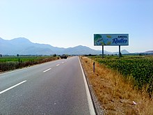
Zadrima
The Zadrima ( Albanian also Zadrimë ) is a geographical and ethnographic region and plain in northern Albania . The area lies between Shkodra and Lezha in the coastal plain along the old course of the Drin and its tributary Gjadër . It includes 40 villages spread over around 350 square kilometers.
The most important villages include Gjadër, Dajç, Pistul, Shkjeza, Mjeda , Hajmal, Troshan and Kallmet. Most of the villages, like little Fishta, are on the edge, a few on hills in the center of the plain. The Zadrima lies in the present day municipalities of Vau-Deja and Lezha; earlier the Komuna Bushat , Hajmel, Dajç and Blinisht as well as the Bashkia Vau-Deja formed the core region of the Zadrima. Together these five municipalities had almost 34,000 inhabitants in 2011.
In the west, the area is closed off by the elongated range of hills Mali i Kakarriqit ( 392 m above sea level ) towards the sea, which is joined to the north by the hills of Bushat ( 249 m above sea level ) and other small hills. In the east, the coastal border mountains , the foothills of the Skanderbeggebirge with Maja e Shitës ( 614 m above sea level ) and Mali i Velës ( 1170 m above sea level ), borders the plain. In the north, the current course of the Drin forms the end, in the south the city of Lezha.
The mostly Catholic area is home to many Albanian clerics such as Frang Bardhi (1606–1643), Lazër Mjeda (1869–1935) and the important poet Gjergj Fishta (1871–1940). The seat of the diocese of Sapa was located on the castle hill of Sapa for a long time before it was moved to Vau-Deja.
The region is still characterized by agriculture today. The Kallmet grape, probably the original variant of the Kadarka and one of the most important Albanian vines , got its name from the village of Kallmet .
The Lezha – Shkodra expressway (SH1) runs across the Zadrima . Since its construction shortly after 2000, the region, which was previously difficult to access, has been better developed. The line of the Albanian railway Hekurudha Shqiptare , however, sticks more to the eastern edge of the plain. In the west is the Gjadër military airfield of the Albanian Air Force .
The name Zadrima is of Slavic origin and means behind the inside .
Web links
Individual evidence
- ^ A b Robert Elsie : Historical Dictionary of Albania . The Scarecrow Press, Lanham 2004, ISBN 0-8108-4872-4 , pp. 495 .
- ↑ a b Territori. (No longer available online.) In: Ndërkomunalja Zadrimë. Archived from the original on October 11, 2016 ; Retrieved October 10, 2016 (Albanian). Info: The archive link was inserted automatically and has not yet been checked. Please check the original and archive link according to the instructions and then remove this notice.
- ↑ Akademia e Shkencave e RPSSH (ed.): Fjalor enciklopedik shqiptar . Tirana 1985, Zadrima, p. 1193 .
- ↑ Ines Nurja: Censusi i popullsisë dhe banesave / Population and Housing Census - Lezhë 2011 . Results Kryesore / Main Results. Ed .: INSTAT . Pjesa / Part 1. Adel Print, Tirana 2013 ( instat.gov.al [PDF; accessed April 14, 2019]).
- ↑ Ines Nurja: Censusi i popullsisë dhe banesave / Population and Housing Census - Shkodër 2011 . Results Kryesore / Main Results. Ed .: INSTAT . Pjesa / Part 1. Adel Print, Tirana 2013 ( instat.gov.al [PDF; accessed April 14, 2019]).
Coordinates: 41 ° 55 ′ 0 ″ N , 19 ° 35 ′ 0 ″ E


