Kir (river)
| Kir | ||
|
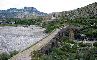
Ottoman bridge Ura e Mesit over the here dry river bed of the Kir |
||
| Data | ||
| location | Albania | |
| River system | Buna | |
| Drain over | In → Buna → Adria | |
| source | on the south side of the Maja e Elbunit 42 ° 18 '30 " N , 19 ° 42' 42" O |
|
| muzzle | in the Drin coordinates: 42 ° 2 ′ 36 ″ N , 19 ° 29 ′ 54 ″ E 42 ° 2 ′ 36 ″ N , 19 ° 29 ′ 54 ″ E
|
|
| length | 52 km | |
| Catchment area | 261 km² | |
| Drain |
MQ |
17 m³ / s |
| Big cities | Shkodra | |
| Communities | Desk , Postriba , Rrethinat | |
| Often there is no water in the lower reaches of the Ura e Mesit | ||
The Kir is a mountain river in northern Albania . It drains the south-western part of the Albanian Alps , known as Dukagjin , with a total area of 261 km². The river is 52 kilometers long. It rises in the heart of the Albanian Alps south of the Biga e Gimajive and flows into the Drin on the southern outskirts of Shkodra, less than a kilometer and a half before it flows into the Buna .
The Quellbach flows for the first three kilometers to the southwest. This is followed by the Kir, cutting through several ravines, in its upper reaches to the village of Prekal, mainly to the south, then to the southwest. Five kilometers northeast of Shkodra, the Kir emerges from the mountains into the plain. In this area around the famous Ottoman bridge Ura e Mesit it often dries out. An old caravan route led over this bridge from Shkodra through the Cukali Mountains to Kosovo . As a result, the Shkodra River passes on the eastern and southern outskirts and then flows into the Drin south of Rozafa Castle . Around the year 1750 the Kir, which previously flowed directly into Lake Shkodra , changed its course to today's route. When the Drin changed its course in 1858, the Kir no longer flowed directly into the Buna, but into the Drin.
In the upper Kir valley there are numerous villages that are not on the river, but on the slopes or on mountain ridges. In the lower Kir valley, the few villages such as Prekal and Ura e Shtrenjtë are located in the valley floor by the water. A simple road leads up the Kir valley, which continues over a 1200 meter high pass into the eastern valley of the Shala .
The Kir is suitable for kayaking over long stretches.
Web links
Individual evidence
- ↑ a b c d Akademia e Shkencave e RPSSH : Gjeografia fizike e Shqipërisë . Tirana 1990
- ↑ Rapid Assessment of proposed Hydropower Plants on Drin River near Ashta (south of Shkodra). Retrieved May 1, 2010 .

