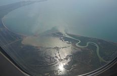
Inside golf
The Drin Gulf ( Albanian Gjiri i Drinit or Pellgu i Drinit ) is a sea bay in the southeastern part of the Adriatic along the coast of northern Albania . The coastline of the Drin Gulf extends from the mouth of the Buna , the border river between Montenegro and Albania, to Cape Rodon north of Durrës . The distance between these two points is 30 kilometers; the coastline is over 60 kilometers long.
The bay is mainly shallow. The central areas are usually deeper than 30 meters, but the deepest points are only 42 meters deep. The subsoil consists primarily of mud and sand. The water temperature averages 1.8 ° C in February and 23.4 ° C in August.
Several large rivers from the Albanian mountains flow into the Drin Gulf: in the south of the Ishëm , a little north of the Mat . The Drin , which gives it its name , now mostly flows into the Buna - the old Drini i Lezhës , which flows directly into the sea, has little water left. The southern part of the gulf between the Mat Estuary and Cape Rodon is also called Gjiri i Rodonit (Rodon Bay) . Apart from the range of hills, the outer tip of which is formed by Cape Rodon, and another range of hills along the northeastern bank, the coast of the Gulf is flat, characterized by extensive wetlands with lagoons . The Patok lagoon is south of the Mat estuary at Fushë-Kuqja , the wetland of Kune-Vain at the Drin estuary and another wetland east of the Buna estuary at Velipoja . The coast is therefore inaccessible over large areas, even if the coastal plain outside these wetlands has been drained since the middle of the last century. In the northern area, a hill ( 561 m above sea level ) stretches for several kilometers along the bay, the lake side of which is not accessible. Here, on the slope of Mali i Rencit, the sand dune Rëra e hedhur (also Rana e hedhun ) can be found.
Shëngjin is the only port on the Drin Gulf. There is another small bay there, Gjiri i Shëngjinit . The port serves as a naval base. Oil is also handled there and some fishermen use it as a base. Fish traps are often used in shallow water . Around 60 species are fished. Also, green turtles and especially turtles use the golf foraging and go at Patok on land. The lagoons are all important wetlands that are used by numerous, sometimes rare, migratory birds as resting places or for wintering.
Shëngin and Velipoja have developed into major seaside resorts in recent years. Numerous hotel complexes have been built along the long sandy beaches, where Albanians from inland and Kosovo in particular relax in summer .
Most of the rivers that feed the Gulf are heavily polluted. Their poor water quality and garbage - especially plastic - also threaten the entire bay. Above all, the Ishëm - because it comes from the capital Tirana - brings a lot of civilization rubbish and stinking water to the bay.
Web links
Individual evidence
- ↑ a b c d Akademia e Shkencave e RPSSH (ed.): Fjalor enciklopedik shqiptar . Tirana 1985.
- ^ Sea Turtle Research in Albania. Retrieved February 7, 2010 .
- ↑ Monitoring and Conservation of Important Sea Turtle Feeding Grounds in the Patok Area of Albania: Annual Report 2009. (PDF) In: Seaturtle.org. Mediterranean Association to Save the Sea Turtles (MEDASSET), December 2009, accessed December 29, 2015 .
Coordinates: 41 ° 46 ′ 0 ″ N , 19 ° 31 ′ 0 ″ E


