Šar Planina
| Šar Planina | |
|---|---|
|
Approximate location of the mountains in the North Macedonian-Kosovar border area |
|
|
North Macedonian side of Mala Kobilica and Golema Kobilica ( 2526 m ) northwest of Tetovo |
|
| Highest peak | Titov Vrv ( 2747 m. I. J. ) |
| location | Kosovo / North Macedonia border |
| Coordinates | 42 ° 0 ′ N , 20 ° 44 ′ E |
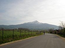
The Šar Planina ( Macedonian and Serbian Шар планина Šar planina , Albanian Malet e Sharrit , also Mali i Sharrit or Sharr ) is a mountain range that extends between Kosovo and North Macedonia and reaches heights of over 2700 meters.
geography
The approximately 80 kilometer long mountain range continues in the southwest in the Korab Mountains . The highest mountains of the Šar Planina include:
- Titov Vrv ( 2747 m )
- Bakardan ( 2704 m )
- Turcin ( 2702 m )
- Borislavec ( 2662 m )
- Rudoka ( 2658 m )
- Crni vrh ( 2585 m )
- Vrtop ( 2555 m )
- Piribeg ( 2522 m )
- Ljuboten ( 2498 m )
On the Kosovar side is the Sharr National Park , which extends over an area of 390 km². There are several winter sports resorts on both sides of the border . The ski area of Popova Šapka on the north Macedonian side can be reached from Tetovo via a good asphalt road with numerous serpentines. The road crosses under a gondola lift leading from Tetovo to the ski area several times .
history
The road was destroyed in the open conflict that broke out in the Šar Mountains in 2000–2001 between Albanians striving for autonomy and the Macedonian army . From February to August 2001 fierce fighting took place between the Albanian separatist militia UÇK and government troops. There were attacks on one side and bombing attacks on villages on the other. In addition to the small town of Aračinovo (Albanian Haraçina ) near Skopje , settlements north of Tetovo were particularly affected. The middle station of the railway with the gondolas parked in it was made unusable by vandalism.
tourism
The ascent on foot from Tetovo, always along the gondola, leads through light mixed forest and takes 3.5 hours. Popova Šapka , located at 1780 meters, consists of around a dozen hotels in the area of the ski lifts and a district with holiday homes. Due to the decline in visitors after 2001, once the most popular ski area in Macedonia , some of the (large) hotels had to be abandoned; the houses are gradually falling apart. Newly built holiday homes in 2007 suggest that the number of holidaymakers will increase again. In summer, Popova Šapka is the starting point for several hiking trails, which are poorly marked but not too difficult, at altitudes of over 2000 meters and lead north to Mount Ljuboten and south to Mount Korab . The best hiking time is May to the end of September. Most of the more than 30 glacial lakes are also over 2000 meters.
Agriculture
The rare Šarski Sir is produced in the Šar Planina , a cheese made from sheep's milk and half cow's milk . It is seasoned with native wild herbs . The cows and sheep are traditionally grazed by shepherds in the vastness of the mountains, where there are also wolves and bears. The herds are protected by the robust Šarplaninac dogs. These are shepherd dogs weighing around 40 kilograms and are considered to be particularly reliable and vigilant.
literature
- Dušan S. Krivolopić: Sar -Planina: Turističkogeografiski prikaz predela i naroda . Turistička Štampa, Beograd 1969.
Web links
- SummitPost.org (English)
- Šar Planina. Macedonia.cjb.net
Individual evidence


