
Titov Vrv
| Titov Vrv | ||
|---|---|---|
.JPG) Titov Vrv (tower) with Krivoshija lake |
||
| height | 2747 m. i. J. | |
| location | Tetovo , North Macedonia | |
| Mountains | Šar Planina | |
| Coordinates | 41 ° 59 '32 " N , 20 ° 47' 53" E | |
|
||
_%D0%BE%D0%B4_%D0%9A%D1%80%D0%B8%D0%B2%D0%B0_%D0%A8%D0%B8%D1%98%D0%B0.JPG) |
||

The Titov Vrv ( Macedonian Титов Врв , Cyrillic Titov Vrh ) is at 2747 m the highest peak of the Šar Planina and after the Korab, the second highest mountain in North Macedonia . It is located about 12 km west of Tetovo .
The Titov Vrv ( Macedonian for Tito's summit ) was named after the former Yugoslav head of state Josip Broz Tito . Before he was called Golem Turčin (Great Turk).
A stone tower almost ten meters high was built on the summit around 1957, which was quite damaged over time. Volunteers restored it at the end of 2016 so that it can now serve as a refuge.
The ascent from Popova Šapka to the top takes around five hours.
photos

Titov Vrv with Mal Turčin (2707 m), right
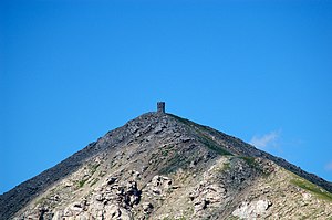
Summit with a tower


Web links
Commons : Titov Vrv - collection of images, videos and audio files
Individual evidence
- ↑ a b Aleksandar Camardžiew: На раце носат материјали да ја обноват планинарската кула. In: Radio Slobodna Ewropa. November 30, 2016. Retrieved December 19, 2016 (Macedonian).
- ↑ Exploring Shar Mountain: Popova Shapka - Titov vrv. In: Shara Mountain Guide. Retrieved December 18, 2016 .