
Korab Mountains
| Mali i Korabit / Korab | |
|---|---|
 Approximate location of the mountains in the north Macedonian-Albanian border area |
|
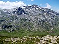
.jpg) The rugged Albanian side around the summit of Maja e Korabit |
|
| Highest peak | Korab mountain ( 2764 m above sea level ) |
| location | Albania , North Macedonia |
| Coordinates | 41 ° 47 ' N , 20 ° 33' E |
| Age of the rock | Paleozoic |
The Korab Mountains ( Albanian Mali i Korabit , Macedonian Кораб / Korab ) is a mountain range in the Albanian - North Macedonian border area. The highest point is Mount Korab , at 2764 m above sea level. A. the highest elevation of the two countries. In Albania there is also the name Vargu Lindor (German Ostkette ), which mostly also refers to mountains further north such as the Koritnik and the Gjallica e Lumës .
The Korab Mountains in the Dibra region extend for 40 kilometers in a north-south direction between the lower section of the Black Drin and its tributary Radika . It is located around the triangle of Albania, North Macedonia and Kosovo, southwest of the Šar Planina Mountains . The mountain ridge that continuously forms the Albanian border is barely less than 2000 meters. The valley of the Drin in the west lies at around 400 meters, the bed of the Radika at around 1000 meters. The Korab Mountains belong to the retreat area of a remaining population of the Balkan Lynx .
In addition to Mount Korab, there are several other, almost equally high elevations. To the north of the double peak lie numerous other nameless rock towers of similar height. The Korab-Pforte summit (Maja Portat e Korabit / Mala Korapska Vrata) , located around two kilometers to the south-west, also reaches the height of the main summit at 2,727 meters. A few hundred meters south of it is another peak ( Maja e Moravës ), which is only slightly lower at 2718 meters.
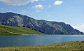
To the south of the Korabbergstocks follow the Grama ( 2345 m above sea level ) and the Dešat with the peak Velivar ( 2375 m above sea level ) as further large mountains . Then the mountain range drops to the town of Debar and Lake Debar . Southwest of Mali i Gramës is the city of Peshkopia , where there are also thermal springs.
The word Korab originally comes from Slavic and comes from a pre-Christian god of the sea. Since the mountain ridge stretches along the Albanian eastern border, the name Vargu Lindor (eastern chain) is also used in Albania . However, this usually means the entire mountain range on the eastern bank of the lower Black Drin, around 70 kilometers in length, up to the Koritnik near Kukës . In literature, the Korab Mountains and the Šar Planina are sometimes combined into one mountain range, the Šar Korab massif .
During the Balkan Wars , the front ran through the region. There are still said to be landmines in the Korab Mountains. Smugglers are said to be often on the move in the border area, which until a few years ago was the scene of fighting between the North Macedonian army and Albanian separatists .

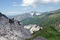
The mountain range from the north Macedonian side
Fusha e Korabit
Grama lake

Dešat
Gypsum rock around the Mali i Bardhë


Web links
- Mountain Club Korab (English) - the North Macedonian mountaineering club organizes the international ascent of the Golem Korab with thousands of participants, North Macedonia's largest sporting event
- SummitPost.org (English)
- Report of an ascent with helpful information
Individual evidence
- ↑ euronatur.org: Project Luchs, project report 2012 - 2013 ( Memento from October 6, 2015 in the Internet Archive )
- ↑ Perikli Qiriazi: Gjeografia fizike e Shqipërisë . New edition edition. Shtëpia botuese e librit universitar, Tirana 2006, ISBN 99927-0-397-0 , p. 189 .