
Bangs (nofels)
| Bangs ( district ) | |||
|---|---|---|---|
|
|||
| Basic data | |||
| Pole. District , state | Feldkirch , Vorarlberg | ||
| Pole. local community | Feldkirch | ||
| Locality | Nofels | ||
| Coordinates | 47 ° 16 '1 " N , 9 ° 32' 39" E | ||
| height | 430 m above sea level A. | ||
 Bangs - former school house, 'Franzosen-Ulme' (until 2013), chapel and Stern inn |
|||
| Source: STAT : index of places ; BEV : GEONAM ; VoGIS | |||

Bangs is one of the four districts ( hamlets ) of Nofels (Nofels, Bangs, Fresch and Matschels ) and belongs to the municipality of Feldkirch .
geography
Bangs is a Vorarlberg border village and is located in the Rhine Valley exactly in the tri-border region between Austria , Liechtenstein and Switzerland . A bridge leads from the former customs building over the Rhine to Lienz SG in Switzerland. Bangs is the westernmost town in Austria.
history
As mentioned under Nofels , the settlement of the wooded floodplains between Schellenberg, Ill and Rhine should have started in the 11th and 12th centuries . Bangs was probably created at this location on the Rhine because there was a passable ford through the Rhine.
In documents from the 14th century, Bangs appears for the first time as a settlement, but the first homes arose here earlier than in Nofels. Other earlier spellings were Bancks, Banx, Banngs, Pangs, Pangen and Abanchs. The names can be derived from the Rhaeto-Romanic banc = bank. In 1655, after an earlier, very small, chapel was demolished, today's chapel was built. However, the tower was only added in the 19th century.
The history of development, like that of Nofels, is shaped by constraints and hardships due to the forces of nature (Ill and Rhine floods) and laborious efforts to achieve independence up to the 20th century . The Ill River flows into the Rhine north of Bangs at Illspitz. In the event of a flood of the Ill, it could mean underwater for Bangs Land due to backwater , even if the Rhine itself did not overflow its banks (as happened in 1910).
Bangs, which developed quite well up to the 18th century (approx. 250 inhabitants, at that time larger than Nofels), was hit by floods more and more often. At the end of the century, due to the steadily increasing risk of flooding, a migration to the slightly higher Nofels began. The Neubangsergasse is still a reminder.

In 1799, in the course of the Napoleonic Wars, a group of French soldiers came to Bangs. Although, according to oral tradition, the scouts left after a meal without causing any great damage, the horror ran deep within the population. A votive picture and a “French elm” planted in front of the chapel in 1818 as a memorial testify to this. The tree was later placed under monument protection, but had to be felled in 2013 due to old age and danger to the public.
In 1909 the old wooden bridge in Gaissau replaced the centuries-old Rhine ferry service between Bangs and Lienz (Switzerland). The stable construction also survived the millennium flood of the Rhine in 1927. Since there was still a risk of flooding in Bangs in the future, an officially ordered construction freeze and further resettlements to Nofels (or emigrations to America) followed. The Wuhr work (dam construction) on the Ill and Rhine were intensified (with a war-related interruption). In 1963 the soil situation had improved so much that the building ban could be lifted again. In 1965 a November Fönsturm destroyed the wooden bridge over the Rhine, whereupon today's reinforced concrete bridge was built.
Attractions

Chapel to St. Sebastian and Fridolin
The existing building was built in 1655 in place of an old chapel by master Jörg Metzler. In 1884 the tower was built and in 1895 the sign and portal were added. Inside there is a baroque altar with a figure of St. Sebastian from around 1500 and a votive picture - next to the chapel itself - shows the invasion of the French hussars in 1799 (note: the painted church tower was fiction).
From 1982 to 1984 the chapel was renovated.
In 2003, Wolfgang Büchel, an organ builder from Nofels, installed the "Lang Hermann Memorial Organ" in the chapel. The organ was consecrated in January 2004.
In 2013, the natural monument in front of the chapel, the so-called "French elm", had to be felled for safety reasons.
Bangs-Matschels nature reserve

In the middle of the densely populated Rhine Valley lies at 430 m above sea level. A. The 450 hectares large Natura 2000 -Naturschutzgebiet Bangs Matschels. It consists of extensive wet meadows and 280 hectares of forest. The protected area is located in the Roten Au, which stretches along the Ill and the Rhine and is the largest contiguous forest area in the Vorarlberg Rhine Valley (see main article: European protected area Bangs-Matschels ).
The litter meadows are ecologically particularly valuable , they are not fertilized and only mowed once a year. Together with the moderately intensively cultivated meadows, they provide a habitat for a large number of rare and endangered animal and plant species. They are home to many species of butterflies that have adapted to nutrient-poor habitats, but also to the corncrake , a species of bird that is threatened worldwide. In early summer, Siberian irises transform the meadows into a bright blue sea of flowers.
There is a driving ban for motor vehicles, but the natural landscape can be explored by bike or on foot.
This area has been used by humans for centuries; there was a small village in Matschels until the end of the 19th century.
Views
Nofels, Bangs and Fresch, view over the Rhine valley towards Feldkirch

Bangser Chapel

Bangs (Nofels) ("French elm") chapel entrance (May 2007)

Gasthaus Stern

Stone bridge border with Liechtenstein (Ruggell)

Plaque "Kaiserthum Österreich" at Steinbrücke

Iris, Siberian iris, called "Fläadrmüs" (bats) by the locals

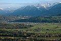
View from Fresch (Schellenberg) to Bangs, with Swiss mountains in the background


Individual evidence
- ^ Franz A. Schatzmann: Local history of the old community Altenstadt. Self-published in 1928
- ↑ Fiel, Karl: Nofels, history of a village. Self-published 1987, ISBN 3-85430-071-9
- ↑ 1818 according to Schatzmann and Fiel (see above). Deviating information from 1813 in Walter Krieg and Rudolf Alge: Vorarlberger Naturdenkmale. Hecht Verlag 1991
Web links
- Bangs from above in the summer film (aerial view) from Vorarlberg Tourismus
- Nofel's homepage at www.feldkirch.at . Events, local newspaper in Nofler, links to Nofler associations
- Votive picture in the Bangs chapel in the Vorarlberg Chronicle - French Wars
- Bangs-Matschels nature reserve (UMG)