
Matschels
| Matschels ( district ) | |||
|---|---|---|---|
|
|||
| Basic data | |||
| Pole. District , state | Feldkirch , Vorarlberg | ||
| Pole. local community | Feldkirch | ||
| Locality | Nofels | ||
| Coordinates | 47 ° 16 '49 " N , 9 ° 33' 34" E | ||
| height | 428 m above sea level A. | ||
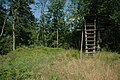
 Weg-Kreuz and "Schatzmanns Ställe" are reminiscent of a former settlement |
|||
| Source: STAT : index of places ; BEV : GEONAM ; VoGIS | |||

Matschels is one of the four districts ( hamlets ) of Nofels (Nofels, Bangs , Fresch , Matschels) and belongs to the municipality of Feldkirch .
geography
Matschels is located north of Nofels and Bangs in the Roten Au, the largest contiguous forest area in the Vorarlberg Rhine Valley . At the northernmost point of the area, the Ill flows into the Alpine Rhine at the so-called Illspitz . There were settlements in Matschels until the end of the 19th century. On the one hand the Ur-Matschels on the Matschelser Bergle (445 m, Inselberg of the Rheintalgrabenbruch, lowest mountain in Vorarlberg, according to today's maps relative height about 16 m) as well as the Obermatschels located further south. Today the hamlet is uninhabited and a nature reserve .
history
As mentioned under Nofels , the settlement of the wooded floodplains between Schellenberg, Ill and Rhine should have started in the 11th and 12th centuries .
In documents from 1355, Matschels is mentioned for the first time as "Montschels", a second mention of this original settlement (around 5 houses) on or on the Bergle occurs around 1407. The name derives from Monticellus = house / farm on the mountain or monticolus = small mountain from. Another, later name was Amatschels.
From around the 16th century onwards, there was increasing flooding of the Rhine and Ill due to the shifting of bed load and the associated elevation of the river beds. This and constant changes in the course of the Ill in the mouth area led to new settlements 1 km further south in Obermatschels and later at the end of the 16th century also to move from the original settlement there (last houses from Bergle transferred in 1775). Obermatschels (now just called Matschels) grew into a small village with 12 farmhouses and a small chapel.

Further floods (30 Rhine incursions in the 18th and 19th centuries alone) ultimately led to complete evacuation. Houses were demolished - often for the second time -, transported to the slightly higher Nofels or Bangs and rebuilt there (Obermatschels' last house demolished in 1892).
All that was left was a stable building, called “Schatzmann's stables” (renewed in 1983). Where the former chapel stood, the wayside cross was later erected by former residents.
As early as 1775, stones were quarried on the north side of the Matschelser Bergle for the Ill dam construction, but an intensive quarry then followed in the years 1924–1926. During this time, about half of the already small mountain was removed.
In 2008, the old Illspitz suspension bridge, which was built in the 1950s with disused wire ropes from the Bregenz Pfänder cable car and thus connected Bangs-Matschels to the community of Meiningen for over half a century, was demolished and replaced by a modern, wider construction that was increased cycling traffic.
Attractions
Bangs-Matschels nature reserve


Area: 450 ha
Location: 430 m above sea level M. in the border triangle Austria-Switzerland-Liechtenstein
In the middle of the densely populated Rhine Valley, as mentioned at Bangs , there is an exceptional natural area with extensive wet meadows and 280 hectares of forest, the Natura 2000 area Bangs-Matschels (since 1974). The litter meadows are ecologically particularly valuable , they are not fertilized and only mowed once a year. Together with the moderately intensively cultivated meadows, they provide a habitat for a large number of rare and endangered animal and plant species. They are home to many species of butterflies that have adapted to nutrient-poor habitats, but also to the corncrake , a species of bird that is threatened worldwide. In early summer, Siberian irises transform the meadows into a bright blue sea of flowers.
There is a driving ban for motor vehicles, but you can explore the wonderful natural landscape by bike or even better on foot and search for clues.
See main article: Bangs – Matschels European Protected Area .
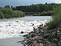
Illspitz

At the Illspitz, the Ill and the Spiersbach (formerly Spirsbach) flow into the Rhine . After the Ill flood in 1999 completely changed the Illspitz, the mouth of the Ill and later in 2008 the mouth of the Spiersbach were redesigned (renatured) in 2001/2002. The measures are also intended to facilitate the ascent from the Rhine into the rivers for fishing. The area around the Illspitz is a popular destination for walkers and cyclists.
In July 2008 it was publicly announced in the media that the construction of a hydropower plant ( Illspitz power plant ) is planned in the Illspitz area.
Views
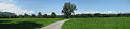
Obermatschels, panorama

Matschelser Bergle, north face (quarry)
Bergle "summit" (left)

View from the Bergle to the south
Illspitz, new bridge (2008)
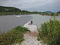
Illspitz, mouth of the Ill (right) into the Alpine Rhine (left)


Illspitz, renatured mouth of the Spiersbach (2008)

View from the Drei Schwestern on the Rote Au , Matschels and Illspitz forest in the Vorarlberg Rhine Valley


Individual evidence
- ↑ Fiel, Karl: Nofels, history of a village. Self-published 1987, ISBN 3-85430-071-9
Web links
- Nofel's homepage at www.feldkirch.at . Events, local newspaper in Nofler, links to Nofler associations
- Bangs-Matschels nature reserve (UMG)