
Fresch (Nofels)
| Fresch ( district ) | |||
|---|---|---|---|
|
|||
| Basic data | |||
| Pole. District , state | Feldkirch , Vorarlberg | ||
| Pole. local community | Feldkirch | ||
| Locality | Nofels | ||
| Coordinates | 47 ° 14 '50 " N , 9 ° 33' 59" E | ||
| height | 545 m above sea level A. | ||
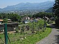
 View of Oberfresch |
|||
| Source: STAT : index of places ; BEV : GEONAM ; VoGIS | |||

Fresch is one of the four districts ( hamlets ) of Nofels (Nofels, Bangs , Fresch, Matschels ) and belongs to the municipality of Feldkirch .
geography
Fresch is located on the northern part of the Schellenberg and has a border crossing to the Principality of Liechtenstein . Fresch is made up of the Oberfresch , Unterfresch , Schüttenacker and Auf der Egg plots .
history
The Schellenberg (formerly also called Eschnerberg ) is one of the oldest settlements in the Rhine Valley ( Rössen culture ), which is why it can be assumed that the higher-lying Fresch (as Alpe) with its plots long before the other Nofler districts (11th to 12th centuries) Century) in the wooded floodplains. Earlier names were Fräsch , Frösch or Am Fresch , which can be traced back to the Romanesque fraska, frascha, which describes a mountain meadow rich in grass.
Fresch was only partially involved in the centuries-old disputes over the use of the common land and flood protection with the old community of Altenstadt, as mentioned by Nofels . The people of Freschner had their private grounds on the Schellenberg and preferred to view the problems of the residents below from a safe distance.
For a long time (until around 1900) viticulture was practiced on the Schellenberg in addition to agriculture and cattle breeding.
Due to the location, however, Fresch could not develop in the same way as the newer districts of Bangs and Nofels in the plain.

If there was too much water on the valley floor (flooding), Fresch often had too little. If the few springs dried up or froze, longer distances (e.g. to the Ruggeller Rietle, where there was once a lake) had to be covered in order to get to the water that is vital for humans and cattle. One was often helpless in house fires. Even after 1959, drinking water was supplied to the residents of Oberfresch in jugs of what was then Feldkircher Milchhof and in 1962 with a fire truck from the volunteer fire brigade . Only since 1973/74 have the 4 hamlets been adequately supplied with water by the drinking water elevated tank Auf der Egg and water pipes.
In addition, the old ways to the Schellenberg were not in a very good condition. The steep forest path from the Nofler customs office or from the former bath up to Unterfresch was still one of the main connections between Nofels and the western hamlets on the Schellenberg until the end of the 19th century. Smooth stone slabs protruded from the ground and after heavy rainfall it was more of a stream than a path. The other connections, the old church path from Nofels to Fresch, also called Gässele , and the path to Schüttenacker, the Wart , were steep and bumpy. It was not until 1891 that the first road was built from the Nofels customs office to Unterfresch, followed in 1927/28 by the construction of Neue Freschner Straße from the former Nofler Spritzenhaus (intersection Rheinstraße - Feldkircherstraße) to Schüttenacker and Oberfresch. During this road construction, the burned remains of the former Furtenbach noble seat at the foot of the Schregenberg (northernmost part of the Schellenberg) were found. In 1970, 1980 and later further improvements followed (widening).

During the night of May 2nd to 3rd, 1945, around 500 soldiers of the 1st Russian National Army , an association collaborating with the Wehrmacht , under Major General Boris Smysłowsky alias Arthuro Holmston (camouflage name) fled across the border of the Greater German Empire to Liechtenstein (Community of Schellenberg ), where they received asylum.
Between Oberfresch and the parcel Auf der Egg used to be the ski area in the vicinity. After the 1992/93 ski season, however, the operation of the Oberfresch lift, which had become unprofitable, was discontinued and - after a few brief re-operations - the surface lift was dismantled at the beginning of 2014.
Schüttenacker has grown the most over the past few years and already has more inhabitants than the other Freschner hamlets put together. And recently grapevines can be seen there again.
Attractions
Chapel of St. Martin and Magnus

- The chapel was built in 1679. The marble stoup is dated to 1736.
- On the neo-Romanesque altar there is a depiction of St. Martin sharing a cloak with a beggar, as well as St. Magnus from 1797.
- In the past, mostly Feldkirch Capuchins read the masses donated in this chapel. On Martin's Day, the Freschner Kilbe, a mass with a sermon was held.
- 1979–1983 a complete renovation took place.
- From the sign of the chapel and generally from Fresch you have a beautiful view down to the mother community and the 3-country corner Austria-Liechtenstein-Switzerland near Bangs in the Rhine Valley .
Views

View of Schellenberg with Fresch (in the foreground bed oaks between Nofels and Bangs)

Oberfresch chapel

Wayside cross on Freschner Strasse near Gigaboga

Houses in Unterfresch 2007, in the background Ruggell (FL)

View from the former ski area Auf der Egg over Oberfresch into Ruggeller Ried and Bangs

On the Egg
Schüttenacker


Individual evidence
- ^ Karl Fiel: Nofels, history of a village. Self-published 1987, ISBN 3-85430-071-9
- ^ Franz A. Schatzmann: Local history of the old community Altenstadt. Self-published in 1928
- ↑ Henning Frhr. v. Vogelsang: To Liechtenstein - to freedom. Community Schellenberg 1980
- ^ Office of the city of Feldkirch - residents' registration office
Web links
Nofels on the website of the city of Feldkirch . Events, local newspaper in Nofler, links to Nofler associations