Eschnerberg
| Eschnerberg / Schellenberg | ||
|---|---|---|
|
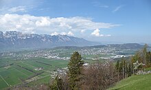
Eschnerberg from the west (Alter Zoll, Gams ) |
||
| height | 698 m above sea level M. | |
| location | Alpine Rhine Valley , Liechtenstein / Vorarlberg border | |
| Mountains | Rätikon ( AVE ), Bregenz Forest Mountains (geological) | |
| Dominance | 3.05 km → Frastanzer Sand | |
| Notch height | 250 m ↓ Tosters | |
| Coordinates , ( CH ) | 47 ° 14 '25 " N , 9 ° 33' 56" O ( 761 023 / 234333 ) | |
|
|
||
| rock | Rhenodanubian flysch | |
| Development | populated | |
| Normal way | Road, high-altitude hiking trail | |
| particularities | Inselberg , Neolithic settlements, medieval castle ruins | |
Eschnerberg , also Eschner Berg, Schellenberg , is up to 698 m above sea level. M. ( Klocker near Hinterschellenberg) high ridge in the Alpine Rhine Valley , on the border between Liechtenstein and Austrian Vorarlberg , near Feldkirch .
geography
The larger, southern part of the mountain is in the Liechtenstein Unterland , the smaller, northern part is in the Feldkirch district , where the region is called the Vorarlberger Oberland . The elevation is about seven kilometers long and two kilometers wide and extends along the Rhine .
On and on its slopes are the villages of Eschen , Mauren , Gamprin , Ruggell and Schellenberg in the south of Liechtenstein and the districts of Fresch ( Nofels ) and Tosters of the nearby town of Feldkirch in the north and northeast of Austria . The highest point is located near Hinter-Schellenberg, on Liechtenstein territory.
Geology and classification
The Schellenberg is a sunken Inselberg formed by the former Rhine glacier , which is the continuation of the Walserkamm . It belongs to the unit of the Rhenodanubian flysch zone of the Alps, called Vorarlberger Flysch , which also builds parts of the Bregenzerwald Mountains - geologically and orographically, along the Esch Canal, the mountain belongs to this mountain group, but according to the definition of the Alpine Association (AVE 1984) it is included in the Rätikon , because it lies south of the Ill (flysch floes can also be found on the neighboring western foot of the Three Sisters ).
Cultural history
The mountain is one of the oldest settlements in the Rhine Valley ( Rössen culture of the Middle Neolithic around 4400 BC), as demonstrated by finds from the Borscht excavation near the community of Schellenberg .
Due to the rule of the Schellenbergs , the mountain got its new name (see also Herrschaft Schellenberg ), however, the historical name Eschnerberg is still often and often used by the Liechtenstein citizens . The Lords of Schellenberg built the castles Neu-Schellenberg (around 1200) and Alt-Schellenberg (around 1250) in the area of today's municipality of Schellenberg . The similarity of the name of the mountain to the Eschinerburg known from Liechtenstein legends is also striking .
ways
The Eschner Höhenweg, a cultural hiking trail, stretches across the mountain .
Web links
- Jürgen Schindler: Eschnerberg. In: Historical Lexicon of the Principality of Liechtenstein .
Individual evidence
- ↑ Statistical Yearbook (2011). (PDF, 1.1 MB) Chapter: 1. Space, environment and energy 1.1 Geography, use of space . Mountains and heights of Liechtenstein . Liechtenstein Statistics Office, 2011, p. 37 , accessed on April 12, 2020 .
- ↑ Office for Communication and Public Relations: Principality of Liechtenstein → Geology. (No longer available online.) Alpen-info.at, archived from the original on May 21, 2012 ; accessed on April 12, 2020 .
- ^ The Obere Burg Schellenberg community bulletin of the community Schellenberg, December 2010 ( PDF ; 4.38 MB ), p. 36, accessed on May 5, 2016
- ↑ Summer competition: Höhenweg over the Eschnerberg. In: vaterland.li → Miscellaneous. Liechtenstein Fatherland, accessed on April 16, 2011 .


