
Eschen (Liechtenstein)
| Ash trees | |
|---|---|
|
|
 |
| Country: |
|
| Constituency : | Unterland |
| Municipality number : | 7007 |
| License plate : | FL |
| Postal code : | 9492 Ash 9485 Nendeln |
| UN / LOCODE : | LI ESC |
| Coordinates : | 757 968 / 231316 |
| Height: | 457 m above sea level M. |
| Surface: | 10.381 km² |
| Residents: | 4459 (June 30, 2019) |
| Population density : | 430 inhabitants per km² |
| Proportion of foreigners : | 34.5% (June 30, 2017) |
| Website: | www.eschen.li |
  |
|
Eschen ( dialect : Escha ) is the largest municipality in the lowlands of the Principality of Liechtenstein . Eschen has an exclave and is therefore a two-part municipality. It is the capital of the Liechtenstein Unterland at the southern foot and on the slope of the Eschnerberg. The hamlet of Nendeln with its own post office belongs to the municipality of Eschen .
Eschen-Nendeln has an industrial character and, with an area of 10,381 square kilometers and a population of 4,459, is the largest municipality in the Liechtenstein lowlands. The district of Eschen has around 2800 and the district of Nendeln around 1400 inhabitants. Neighboring communities are Gamprin , Schellenberg , Mauren , Frastanz in Austria , Planken , Schaan , Vaduz (section Riet ) and, separated by the Rhine, Buchs SG and Sennwald in Switzerland .
geography

| ||||
Municipality of Eschen with the Rheinau-Tentscha exclave |
With an area of 10.33 km², Eschen is the largest municipality in the Liechtenstein lowlands . The village of Eschen is located on the southern slope of the Eschnerberg and on two hills in front of it. South-east of Eschen, at the foot of the Three Sisters Massif , lies the village of Nendeln, separated by the Riet through which the ash flows. Eschen borders in the north on Schellenberg , in the west on Gamprin , in the southwest on the Swiss communities Buchs (SG) and Sennwald , in the northeast on Mauren , in the east on Frastanz in Vorarlberg and in the south on Planken and Schaan .
In the southwest, Eschen has the Rheinau-Tentscha exclave with floodplains and farmland. The Herbert Ospelt Anstalt production facility belonging to Bendern by post is located in this exclave . The exclave is separated from the rest of the Eschner municipal area by a 500 meter narrow strip of territory belonging to Gamprin with the Unteratzig industrial area.
history
Ash trees
Eschen is first mentioned in a document in the Churrätischen Reichsguturbar from 842 in the form of "Essane". This name is probably due to the Celtic "esca", which means "located on the water". The prehistoric settlement areas of Malanser and Schneller are located in the municipality of Eschen.
A specially created “Historic Eschnerberg High Trail” offers hikers many opportunities and at the same time shows those interested in history a picture of an eventful history. The oldest references to human settlement that we currently know from the area of today's Principality of Liechtenstein come from the hilltops of Malanser, Lutzengüetle and Borscht on the Eschnerberg . They date from around 4700 to 4000 BC. Bones and stone tools, ceramic shards and traces of buildings were documented as the legacy of the settlers of that time.
Nendeln
In written evidence from the 14th to the 18th century, the term “Nendlen” is not used, but rather the term “Nendlen” (cf. the dialect form “Nendla”). There is no reliable knowledge of the origin of the place name «Nendeln».
Since 1872 Nendeln has been connected to the Feldkirch – Buchs railway line (see Nendeln station ).
→ Main article: Nendeln
badges and flags
|
|
The coat of arms of Eschen was awarded on April 16, 1942. It shows a silver pigeon with a bloody wood chip in its beak above in the blue shield and below the silver wavy band of the ash tree.
The silver dove with the bloody wood chip is taken from the coat of arms of the Pfäfers monastery and represents a reference to the founding legend of this monastery. The Pfäfers monastery held the parish of Eschen until its abolition (1838) .
The flag of the municipality of Eschen-Nendeln is blue, divided in the middle by the silver ribbon of the ash tree.
politics
The community leader is Günther Kranz (VU) (since 2011). The council has eleven seats: VU and FBP each with five seats and DU with one seat.
Attractions
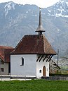
The Holy Cross Chapel on the former place of execution and assembly in Rofenberg probably dates from the early 16th century.
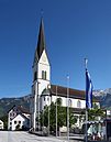
The neo-Gothic parish church of St. Martin was built in 1894 on the site of an early medieval church that was expanded in 1438

The guards next to the parish church date from the 14th century and are a reminder of the long membership in Pfäfers monastery.

The mill, which was Torkel until 1911 and then converted into a mill, was in operation until a few years ago.


economy
The companies Novodent and ThyssenKrupp Presta , among others, have their headquarters in Eschen .
Personalities

- Gerard Batliner (1928–2008), politician and lawyer, Liechtenstein head of government 1962–1970
- Ewald Hasler (1932–2013), cyclist
- Alois Lampert (1932–1977), cyclist
- Herbert Marxer (* 1952), ski racer
- Rudolf Lampert (* 1956), politician (FBP)
- Ivo Klein (* 1961), politician, Vice President of the State Parliament
- Günther Marxer (* 1964), ski racer
- Konstantin Ritter (* 1964) cross-country skier
- Markus Hasler (* 1971), cross-country skier
More pictures

Ash trees, Alpstein in the background

Parish hall


Web links
- Website of the municipality of Eschen
- Ulrike Mayr, Jürgen Schindler: Eschen. In: Historical Lexicon of the Principality of Liechtenstein .
- Arthur Brunhart: Ash trees. In: Historical Lexicon of Switzerland .
Individual evidence
- ^ Tables of population statistics. (XLS; 345 kB ) June 30, 2019. Statistical Office (AS), Principality of Liechtenstein, accessed on December 24, 2019 .
- ↑ population statistics. ( PDF ; 913 kB ) June 30, 2017. Statistical Office (AS), Principality of Liechtenstein, p. 15 , accessed on January 31, 2018 .
- ↑ a b Ulrike Mayr, Jürgen Schindler: Eschen. In: Historical Lexicon of the Principality of Liechtenstein . December 31, 2011 .
- ↑ Map extract from OpenStreetMap, accessed on March 31, 2019
- ↑ Map section of the Swiss national topography, accessed on March 31, 2019