
Planks
| Planks | |
|---|---|
|
|
 |
| Country: |
|
| Constituency : | Oberland |
| Municipality number : | 7006 |
| License plate : | FL |
| Postal code : | 9498 |
| Coordinates : | 759 588 / 228208 |
| Height: | 786 m above sea level M. |
| Surface: | 5.341 km² |
| Residents: | 478 (June 30, 2019) |
| Population density : | 89 inhabitants per km² |
| Proportion of foreigners : | 26.6% (June 30, 2017) |
| Website: | www.planken.li |
  |
|
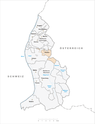
Planken ( dialect : Planka ) is a municipality in the Oberland of the Principality of Liechtenstein . Planken has four enclaves and two enclaves . With around 400 residents, it is the smallest municipality in the principality in terms of population. Planken became known through the Olympic ski champion Hanni Wenzel .
geography

| |||||
Exclaves of the community of Planken |

The community of Planken is located on the western slope of the Three Sisters Massif . The village center is located on a mountain terrace 786 m above sea level. M. across the Rhine plain northeast of Schaan . The municipal area also includes the Oberplanken high plateau and several Alps and exclaves. Planken borders Schaan in the south and west, the Gampriner exclave Nendler Berg in the north , the Vaduz exclave Dachsegg and Eschen and in the east the Austrian municipality of Frastanz .
The exclave Planken Garselli is a former Alp in Saminatal . The Plankner Neugrütt is a steep forest above Planken, which is only separated from the rest of the municipality by a strip around 20 meters wide. This exclave is surrounded on three sides by the Schaan exclave of the same name . The other two exclaves are on the valley floor: Wes is a small meadow surrounded by the Schaan municipality and forest; Riet-liming a facility located in Schaan advised Riedwiese .
Planken has two wooded enclaves. Rüttistein belongs to the municipality of Vaduz, Brunnenegg to Schaan.
Alps

The Alp Gafadura on the western slope of the Three Sisters massif was probably as Saroja after 1300 of Triesenberg ago by Walser populated and inhabited until the mid-15th century. In 1579 the owners of Gafadura, Gaflonen (today Alpzinka) and Garselli transferred their alpine rights to the municipality of Planken, which turned the cooperative into a municipal alp . However, the alp was still managed by individual healers, it wasn't until 1875 that a community dairy was introduced and a community stable was built. To 1945/50, the dairy has been set, since the 1960er.Jahren is mainly Galt cattle summered. In addition, forestry has always played a role.
The Gafadurahütte was built in 1926 as a princely hunting lodge and taken over by the Liechtenstein Alpine Association in 1968 .
Alpzinka was first mentioned in 1428 and probably remained inhabited until the middle of the 15th century. Since then, the forest and pasture slope that today belongs to Alp Gafadura has been used for alpine farming.
Rütti, formerly also known as «Maiasäss», serves as Maiensäss for Gafadura.
The Planken Garselli located on the west side of the lower Sami Natal . Already in the early 19th century the use of the steep, heavily rutted and very dry alp was not very intensive and was limited to Galtvieh. It ended between 1880 and 1890. The Plankner Garselli has been part of the Garselli / Zigerberg forest reserve since 2000 .
| Alp | origin of the name | Owner | Total area | Pasture area | Alpine building | source |
|---|---|---|---|---|---|---|
| Gafadura ⊙ | alt rät.rom. cavradüra ( clearing ) | Planken community | 90 ha | 24 ha | 1410 m above sea level M. | |
| Alpzinka ⊙ | pointed part of the alp | 1625 m above sea level M. | ||||
| Rütti ⊙ | Mentioned in 1607 as Reiti (clearing) | 22 ha | 997 m above sea level M. | |||
| Plankner Garselli ⊙ | alträt.rom. clusella (small valley narrow ) (?) | 187 ha | - | 1311 m above sea level M., departed |
||
history

The village name Planken is derived from the Romance word plaunca , which is translated as Halde . The Romanesque population from Schaan and Vaduz cleared the area of today's village before the Walsers probably immigrated there towards the end of the 13th century and cleared further areas on the upper mountain slopes. The first written mention of Planken is from 1361. The village suffered two major war pillages: in 1499, when the Confederates marched over Planken to Frastanz , and in 1799 by the French , after they had driven out the imperial troops that were quartered in Planken .
In 1868 Planken was connected to the road network, so that large wagons could now also enter the village and it was no longer only accessible via footpaths. After a major fire in 1869, there was a strong migration. In 1901 the village only had 56 inhabitants. The consolidation of 1961–1981 and an improved infrastructure improved the situation in Planken again.
coat of arms

The shield is divided diagonally to the left into white and green. In front a six-pointed gold star .
politics
Rainer Beck ( VU ) has been the community leader since 2007 .
In the municipal election on March 15, 2015, he received 67.3% of the valid votes. There has been the following distribution of mandates since the 2015 municipal elections:
Attractions


Chapel St. Josef : From an ecclesiastical point of view, Planken belongs to the parish of Schaan, but has its own church with the St. Josef chapel. The chapel was probably built in 1767 and a tower was added in 1861. In 1929 Prince Franz I donated three neo-baroque altars to the church. Finally, in 1955, renovations were carried out so that the chapel received its final appearance at that time. In the course of this work u. a. the tower built in 1861 was replaced by a hexagonal wooden roof turret. An old bell from 1724 hangs in it.
Personalities

- Gustav Jehle (1908–1991), farmer and politician
- Hanni Wenzel (* 1956), ski racer
- Andreas Wenzel (* 1958), ski racer
- Tina Weirather (* 1989), ski racer
photos

Dorfstrasse at the entrance to the village

Chapel of St. Joseph

The municipal administration has been located in the three-sister house since 1991.


Web links
- Website of the municipality of Planken
- Ulrike Mayr, Oliver Stahl: Planks. In: Historical Lexicon of the Principality of Liechtenstein .
- Arthur Brunhart: Planks. In: Historical Lexicon of Switzerland .
Individual evidence
- ^ Tables of population statistics. (XLS; 345 kB ) June 30, 2019. Statistical Office (AS), Principality of Liechtenstein, accessed on December 24, 2019 .
- ↑ population statistics. ( PDF ; 913 kB ) June 30, 2017. Statistical Office (AS), Principality of Liechtenstein, p. 15 , accessed on January 31, 2018 .
- ↑ a b c Ulrike Mayr, Oliver Stahl: Planken. In: Historical Lexicon of the Principality of Liechtenstein . December 31, 2011 .
- ↑ Map excerpt from Swisstopo, accessed on April 20, 2019
- ↑ a b Oliver Stahl: Gafadura. In: Historical Lexicon of the Principality of Liechtenstein . December 31, 2011 .
- ↑ a b Oliver Stahl: Alpzinka. In: Historical Lexicon of the Principality of Liechtenstein . December 31, 2011 .
- ↑ a b Oliver Stahl: Rütti. In: Historical Lexicon of the Principality of Liechtenstein . December 31, 2011 .
- ↑ a b Oliver Stahl: Garselli. In: Historical Lexicon of the Principality of Liechtenstein . December 31, 2011 .
- ↑ Liechtenstein Name Book (online), accessed on April 20, 2019
- ↑ FL municipal elections 2015 - Planken
- ↑ Cornelia Herrmann: The art monuments of the Principality of Liechtenstein. 2007, pp. 409-411.