
Ruggell
| Ruggell | |
|---|---|
|
|
 |
| Country: |
|
| Constituency : | Unterland |
| Municipality number : | 7010 |
| License plate : | FL |
| Postal code : | 9491 |
| UN / LOCODE : | LI RGL |
| Coordinates : | 758 322 / 234600 |
| Height: | 433 m above sea level M. |
| Surface: | 7.378 km² |
| Residents: | 2295 (June 30, 2019) |
| Population density : | 311 inhabitants per km² |
| Proportion of foreigners : | 26.2% (June 30, 2017) |
| Website: | www.ruggell.li |
  |
|
Ruggell ( dialect : Ruggäll ) is a municipality in the lowlands of the Principality of Liechtenstein . It is the northernmost municipality in the principality and is located on the plain of the Alpine Rhine Valley , at the foot of the Eschnerberg (also known as Schellenberg ). Because of this level (flat) topography, Ruggell is known as a «bicycle village».
Residents

Ruggell has 2,135 inhabitants - 1,060 of them are male and 1,075 are female (as of June 30, 2015). The nationalities are distributed as follows: 1575 are Liechtensteiners (73.8%), 560 have other nationalities (26.2%). In December 2010 the municipality of Ruggell had reached the population of 2000 people.
history

The name Ruggell was mentioned in an earlier time, for the first time around 933 AD, on a sales contract that is now in the St. Gallen Abbey Archives . It comes from the expression roncale - ad roncalem , which means something like clearing, to make arable. However, people settled here in earlier times, as is shown by Bronze Age and Roman Age finds in the Ruggeller Riet: decorative pins, a bronze lance tip, a bracelet and a bronze brooch .
Later historical documents refer to the constant struggle with the Rhine and, as a result, to wetness, cold and famine. Therefore, the history of Ruggell is deeply rooted in the Rhine . The river repeatedly brought suffering and misery to the village through floods and devastated it until the Rhine was tamed and canalized after the last Rhine collapse in 1927. Since then, the water has lost its horror.
Ruggell was a farming village - practically every household also ran a small farm with a few cows, chickens and pigs, mostly for their own use or as extra income. Today there are only a few farmers left. Most of these are resettled on resettlement farms. There are only about two or three farmers left in the village. So the "village romantic" idyll with chickens, cows and dung heaps has disappeared from the village scene; Single-family houses with well-tended gardens and squares now shape its character.
The resident population has more than doubled in the past 30 years. Today more than 2000 people live in the northernmost and lowest lying community in the country. In addition to historical buildings such as the parish church of St. Fridolin, built in 1899 by the Viennese architect Gustav von Neumann, the village image is characterized by modern private and commercial buildings.
In terms of infrastructure, Ruggell has administration, schools, post offices, restaurants, leisure facilities, commercial operations, communal TV channels, footpaths and bicycle paths, building permits for apartments and businesses and good access to public transport. Local supplies for the residents are also provided.

Ruggell, in the mid-1920s
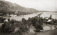
Ruggell during the 1927 Rhine flood
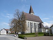
Parish church of St. Fridolin from 1899


coat of arms
In the red shield over a blue, white-lined wave bar, which symbolizes the Rhine and near the base of the shield is a golden stalked ear of corn, this symbolizes the reed with its cornfields with side leaves on both sides of the stalk.
geography

Ruggell is the northernmost municipality in the principality and borders directly on Austria (Riet / Scheidgraben) and separated by the Rhine , including Switzerland. The Bangserfeld, north of the confluence of the Liechtenstein inland canal into the Rhine, which was renatured a few years ago , forms the triangle of Liechtenstein-Switzerland-Austria. Between the Bangserfeld and the Bangserwesa lies the lowest point in the Principality of Liechtenstein at around 430 meters above sea level (the highest point in the country is the Vorder-Grauspitz in the Rätikon at 2599 meters above sea level).
There is a mild alpine climate, which is characterized by the sometimes stormy " Föhn ". The temperatures fluctuate between −15 ° C in winter and sometimes over 30 ° C in summer.
Flora and fauna

On the north side of the Eschnerberg is the Ruggeller Riet, a 90-hectare nature reserve rich in fauna and above all flora . The reed was created after the Rhine glacier melted around 16,500 years ago and the subsequent formation and siltation of shallow lakes. The peat extraction , which has probably been significant since the 19th century , declined after the Second World War. Of the originally around 100 peat huts, 12 still stood in 1982.
To the great biodiversity of Ruggeller Riets include Torfmoosdecken , moor grass meadows , small sedge and head rush communities . The Siberian Iris ( Iris sibirica ) blooms at the end of May to June , which is then the main blooming aspect in large parts of the nature reserve. 736 plant and 1631 animal species occur in the Ruggeller Riet, including the stork and the curlew , which has disappeared as a breeding bird since 1997.
The Ruggeller are popularly known as “Lättaknätter”. This expression also comes from the Riet. The loamy soil that occurs here is called «Lätta». In the past, peat was also cut in the Riet . The peat was used for firing, i.e. heating the houses. This old tradition has increasingly disappeared in recent years.
language
The official language is German. The colloquial language spoken is an Alemannic dialect , which is a mixture of the neighboring Vorarlberg and Swiss dialects.
politics

The municipal council and mayor elections held every four years brought some innovations in January 2007:
Ernst Büchel of the Progressive Citizens' Party (FBP; the blacks) became the new head of Ruggell. He replaced the previous head of the Fatherland Union (VU; die Roten), Jakob Büchel, after eight years of office. The FBP thus again appointed the head of Ruggell after 24 years of VU head. This is chosen separately and directly in the majority system .
In the elections in January 2011, the incumbent chief Ernst Büchel was re-elected for a further four years. No candidate was nominated by the Patriotic Union.
After eight years in office as head of department, Büchel was no longer a candidate for the 2015 elections. Maria Kaiser-Eberle, also from the Progressive Citizens' Party (FBP), was elected with a narrow majority as her successor. Mario Wohlwend from the Fatherland Union (VU) ran as the opposing candidate. At that time, Kaiser-Eberle was the only municipality head in the country and the second woman to hold this office in Liechtenstein. In 2019 she was confirmed in office with 80.6% of the valid votes, but is no longer the only head in Liechtenstein - there is also a woman head in Triesen .
The municipal council has eight members. He is elected by the population of Ruggell ( proportional representation ). Even after the municipal elections on March 24, 2019, four members each belong to one of the two parties FBP and VU.
religion
The overwhelming majority of the Ruggell population (80.2%) is Roman Catholic , 10.4% are Protestant and 4% belong to other denominations and religions, 5.4% do not belong to any religious community or did not provide any information (as of 31. December 2010).
Culture

Ruggell has a lively and active club life. There are about 25 clubs , including the football club FC Ruggell (which celebrated in 2008 its 50th anniversary), the Musikverein Frohsinn (this 2010 celebrated its 125th anniversary), choirs (women's and men's chorus), Boy Scouts / inside St . Fridolin , tennis club , table tennis club , judo club , shooting club , Velo Club (VC Ruggell - wheel criterion respectively in July of each year - earlier Schellenberg Tour; stage on the Tour de Suisse ), women's gymnastics club, radio guild Häxawahn , volunteer fire department (125-year celebration in June 2006) , JAG youth work group of the Lower Land communities Ruggell-Schellenberg-Gamprin.
Ruggell attaches great importance to maintaining tradition, its customs and their preservation. In the Küefer-Martis-Huus village museum , a listed building from the 18th century, there are regular exhibitions, lectures and lectures on various topics and specialist areas.
There are also various documentations in the form of books, writings, CDs (dialect / dialect), videos / DVDs (e.g. peat cutting, fishing) about life in Ruggell.
economy
Ruggell is the seat of the Liechtenstein Life Insurance Company.
Attractions

- Parish Church of St. Fridolin (1899)
- Küefer-Martis-Huus village museum
- Renatured canal confluence with the Rhine
- Ruggeller Riet (marshland with very rich flora and fauna)
- Three-country point (FL-A-CH)
Personalities
- Adolf Heeb (* 1940), cyclist and politician, born in Ruggell
- Klaus Tschütscher (* 1967), Head of Government of Liechtenstein from 2009–2013
- Marcel Tschopp (* 1974), long-distance runner and doctor, born in Ruggell
- Armin Öhri (* 1978), writer
- Martin Büchel (* 1987), professional soccer player
- Benjamin Büchel (* 1989), professional soccer player, born in Ruggell
Web links
- Website of the municipality of Ruggell
- Jens Gassmann, Fabian Frommelt, Ulrike Mayr: Ruggell. In: Historical Lexicon of the Principality of Liechtenstein .
- Arthur Brunhart: Ruggell. In: Historical Lexicon of Switzerland .
Individual evidence
- ^ Tables of population statistics. (XLS; 345 kB ) June 30, 2019. Statistical Office (AS), Principality of Liechtenstein, accessed on December 24, 2019 .
- ↑ population statistics. ( PDF ; 913 kB ) June 30, 2017. Statistical Office (AS), Principality of Liechtenstein, p. 15 , accessed on January 31, 2018 .
- ↑ a b Ruggeller Riet nature reserve. On the website of the municipality of Ruggell, accessed on June 16, 2019
- ↑ a b c Nidija Felice, Anna Merz: Ruggeller Riet. In: Historical Lexicon of the Principality of Liechtenstein , accessed on December 31, 2011 .
- ↑ 2010 Census - Volume 1 Population Structure December 31, 2010. Statistical Office (AS), Principality of Liechtenstein, p. 25, accessed on March 25, 2016 (PDF; 768 kB)