Triesenberg
| Triesenberg | |
|---|---|
| banner | coat of arms |
| Country: |
|
| Constituency : | Oberland |
| Municipality number : | 7004 |
| License plate : | FL |
| Postal code : | 9497 |
| Coordinates : | 759 578 / 220732 |
| Height: | 886 m above sea level M. |
| Surface: | 29.694 km² |
| Residents: | 2643 (June 30, 2019) |
| Population density : | 89 inhabitants per km² |
| Proportion of foreigners : | 20.6% (June 30, 2017) |
| Website: | www.triesenberg.li |
| Location map of Triesenberg in the Principality of Liechtenstein | |
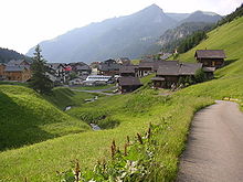
Triesenberg ( dialect : Trisabäärg ) is a municipality in the Oberland of the Principality of Liechtenstein . Triesenberg has an exclave ( Turna and Sareis with the town of Malbun ) and thus consists of two non-contiguous areas. In terms of area, it is the largest and highest situated municipality in the principality. Triesenberg is a hamlet settlement with the hamlets of Rotenboden, Jonaboden, Wangerberg, Steinort / Lavadina, Masescha and Silum . In addition, the community is a resort.
geography
Localities of the municipality of Triesenberg |
With around 29.7 square kilometers, Triesenberg is the largest municipality in the country in terms of area. The village center is at an altitude of around 900 m above sea level. M. on a terrace that was created around 9,500 to 14,000 years ago by the Triesenberg landslide. Triesenberg is thus also the highest village in the principality. In the west, Triesenberg borders on Triesen , Schaan and Vaduz , in the north on Planken , in the south on the Alp Gapfahl and Triesen, which belongs to Balzers , and in the east on the Alps Front / Middle valorsch / Guschg (municipality of Schaan), Hahnenspiel (Vaduz) and Gapfahl (Balzers). Triesenberg also has an exclave that extends around the town of Malbun with the Turna and Sareis Alps . In addition to Malbun, the towns of Masescha, Silum , Gaflei and Steg also belong to the Triesenberg community.
Steg and Malbun can be reached through the Gnalp – Steg tunnel .
Alps
The Alps are still important to Triesenberg today. With 2632 hectares, Triesenberg has the most extensive alpine property in the country. In order to use the settlement area as intensively as possible, there is a mixed hay and pasture farming. Between the homesteads and the high communal Alps that are not suitable for haying, Maiensasses serve as an intermediate stage.
→ Main article: Triesenberg Alps
history
Walser hike
The Walsers who immigrated from the end of the 13th century were probably the first to settle permanently in the Triesenberg area. The first written testimony from Walsers on the Triesenberg can be found in a document from 1355, in which they are awarded a part of the Malbun Alpe, as they "previously had". Accordingly, they must have settled and taken Alps as fief before this date .
Prehistoric stray finds (originals in the Liechtenstein National Museum , copies in the Walser Heimatmuseum) and Romanesque field names such as Guflina, Runggelina, Lavadina etc. indicate a pre- Walser use of the area. The process of displacing the Romance language was completed around the time of the Walser immigration.
The Walsers first settled the higher elevations and only later spread down into the valley. Settlements with different hamlets were formed.
The “Free Walser” were given special freedoms for their clearing activities. With the “Free Hereditary Order” they had a particularly favorable right of ownership and use. They were exempt from taxes and only had to pay interest. In 1618, under the Counts of Hohenems , the special rights of the Walser were abolished, i. that is, they became serfs like the other citizens of the country.
In 1652 the alpine ownership was reorganized. The Alps - with the exception of the Maiensassen Steg and Silum - arrived and the cooperatives remained in the community's possession. The rural economy remained the single dairy until 1888 . The common alpine cultivation took place against considerable resistance from the farmers.
Later developments
After the Second World War there was a great economic upswing and a large part of the working population of Triesenberg found employment in the industrial and service companies in the valley. Triesenberg became a commuter community.
From 1960 to 1993 a total improvement (soil consolidation) was carried out. Agriculture has steadily declined since the Second World War. Today more than two thirds of the workforce work in industry and service companies in the valley communities.
Even today, the Walser German dialect of the residents of Triesenberg shows the cultural influence of the Walser.
→ See also: Walser in Liechtenstein
Triesenberg was - together with Triesen and Balzers - one of the last three communities in Liechtenstein to allow women to vote on the community level on April 20, 1986 .
coat of arms
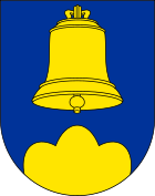
A golden bell with an equally colored clapper hovers in the blue coat of arms above a golden three-mountain : A chapel was probably built on Masescha soon after the Walsers immigrated, where the Walser saint Theodul is venerated to this day . The Theoduls bell has been part of the municipal coat of arms since 1955.
Culture and sights
- Walser Museum Triesenberg : The museum shows the way of life of the Walsers who immigrated in the 13th century, and also shows the parish history and customs of the community. Also attached to the museum is a 400-year-old Walser house , which reflects the living culture of the time.
- Parish church of Prince Josef Wenzel : Until the establishment of its own parish in 1768, Triesenberg was assigned to the parishes of Triesen and Schaan . From 1767 to 1769 the first parish church of Triesenberg was finally built. The church consisted of a single nave and a closed choir . The tower represented an onion dome with a square shaft and an octagonal bell storey. In 1938, the old parish church was finally demolished, whereby many furnishings have been preserved. For example, one of the bells was moved to the Peace Chapel in Malbun.
- Parish Church of St. Josef : Between 1938 and 1940, the new parish church was built on the site of the demolished parish church. The church is oriented to the northeast and stands on a raised terrace in the center of Triesenberg. As with the old parish church, an onion dome was built that is unique in Liechtenstein. The church has five bells, with four bells from the old parish church being melted down for casting the new one.
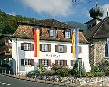
- Town hall : With the construction of the first parish church, a rectory was built on the northern edge of the church square. In contrast to the old parish church, the parsonage was not demolished, but converted into the seat of the municipal administration in 1967–1968, and so the building is now the municipality's town hall.
- Friedenskapelle von Malbun : The chapel is located in the northern part of the skiing and hiking area Malbun and represents the highest church in the principality. The chapel was built in 1950/51, the bell comes from the old parish church of Triesenberg, which had been broken down. The chapel got its name as a token of thanks for the sparing of Liechtenstein from the atrocities of the Second World War.
- Chapel of St. Theodul : The chapel is located in Masescha and goes back to an original building that was probably built shortly after the arrival of the Walsers around 1300. The chapel was first mentioned in a document in 1465. Over the centuries, the church has been rebuilt and expanded again and again. The St. Theodul Chapel (formerly Sta. Maria Chapel) has been extensively renovated since the 19th century.
- Chapel of SS. Wendelin and Martin : The chapel of SS. Wendelin and Martin (also called Stegkapelle) is located in the Steg settlement . The chapel has its origins in a wayside shrine and was consecrated to Saints Wendelin and Martin in 1817 and was subsequently expanded into a small chapel. After it was devastated by a storm in 1830, the church was restored and expanded again. In the years 1906/1907 the chapel was extensively rebuilt and received its current appearance.
- Geographical center of Liechtenstein : The geographical center of Liechtenstein is on Alp Bargälla , east of Gaflei. The center is marked by a boulder weighing around four tons .
Sub-locations
Malbun
Malbun is a high valley at around 1600 m above sea level. M. and consists of the Alps Turna (Gemeindealpe) and Pradamee (cooperative alpine pasture of Vaduz). The name Malbun comes from Romansh and comes from alp bun 'beautiful, productive alp' or val bun 'beautiful, productive valley'.
Around 1925 Malbun consisted of a scattered settlement with around 50 Maiensäss huts . Since the late 1950s, Malbun has been expanded into a skiing and hiking area that today includes numerous holiday homes, hotels and restaurants. It is the only winter sports area in Liechtenstein.
Malbun is also a destination for mountain stages of the Tour de Suisse (2004, 2007 and 2011), as well as the destination of the LGT Alpine Marathon.
web
Steg is located in the Samina valley and was once a mountain pasture for the farmers of Triesenberg. The Steg settlement consists of the parts of Grossstäg and Chleistäg with around 80 and 45 huts, respectively, most of which have been converted into holiday apartments. The houses in both settlements are located around a meadow area. The Steg reservoir and the Gänglesee are in the immediate vicinity of the settlement . Today Steg is the starting point for many different hikes in summer - in winter it offers a one kilometer long natural toboggan run and a few kilometers of cross-country ski trails .
Gaflei
Gaflei is at around 1500 m above sea level. M. in the north of Triesenberg. Gaflei was the first health resort in Liechtenstein, and although the former health resort no longer exists, Gaflei has remained a popular recreational and excursion area. In 1976, Gaflei was a stage stop of the Tour de Suisse and went down as one of the most demanding stages in Tour de Suisse history.
Masescha
Masescha was one of the first settlements of the Walser (Valais) and is located at an altitude of about 1,250 meters on the access road to Gaflei. The settlement has the character of a scattered settlement , with very few buildings being inhabited all year round.
politics
Since the municipal elections on March 15, 2015, the community leader has been Christoph Beck of the Fatherland Union (VU), who replaced Hubert Sele . The municipal council has had eleven seats since the 2015 municipal elections:
Personalities
Daughters and sons of the church
- Alois Gassner (1847–1916), pioneer and rancher in Oregon , United States
- Justina Gassner (1848–1920), née Lampert , pioneer and rancher in the United States
- Wilhelm Beck (1885–1936), co-founder of the Patriotic Union party (1918)
- David Beck (1893–1966), archaeologist and local historian
- Max Gassner (1926–1994), ski racer
- Leopold Schädler (1926–1992), ski racer
- Franz Beck (1930-2000), ski racer
- Ewald Eberle (* 1933), ski racer
- Josef Gassner (* 1944), ski racer
- Hans-Walter Schädler (* 1945), ski racer
- Wolfgang Ender (* 1946), ski racer
- Arnold Beck (1949–2014), ski racer
- Martha Bühler (* 1951), ski racer and hotel owner
- Werner Sele (* 1951), luge rider
- Wolfgang Schädler (* 1958), luge rider
- Marco Schädler (* 1964), composer
- Jolanda Vogt-Kindle (* 1965), ski racer
- Jacqueline Vogt (* 1969), ski racer
- Wendelin Lampert (* 1970), politician (FBP)
Other people
- Jakob Vetsch (1879–1942), Swiss dialect researcher and writer, lived from 1927 to 1934 in the hamlet of Rotaboda northeast of the village center of Triesenberg. In the Principality of Liechtenstein he took part in the relief operation for the benefit of the population affected by the Rhine dam on September 25, 1927.
- Engelbert Bucher (1913–2005), pastor of Triesenberg and Catholic dignitary from 1943, is an honorary citizen of Triesenberg, where he also died
- Hans Hass (1919–2013), diving pioneer and marine researcher, lived from 1960 to 2006 in the historic Walser farmhouse "Waldi" in Masescha.
literature
- Adulf Peter Goop : Customs of Liechtenstein. Old customs and new manners. Alpenland Verlag, Schaan 2005, ISBN 3-905437-09-0 .
- Cornelia Herrmann: The Art Monuments of the Principality of Liechtenstein (= The Art Monuments of Switzerland . Volume 112 ). Part 2: The Oberland. Society for Swiss Art History (GSK), Bern 2007, ISBN 978-3-906131-85-6 .
Web links
- Website of the Triesenberg community
- Herbert Hilbe, Ulrike Mayr: Triesenberg. In: Historical Lexicon of the Principality of Liechtenstein .
- Arthur Brunhart: Triesenberg. In: Historical Lexicon of Switzerland .
- The Triesenberg parish was founded 200 years ago .
Individual evidence
- ^ Tables of population statistics. (XLS; 345 kB ) June 30, 2019. Statistical Office (AS), Principality of Liechtenstein, accessed on December 24, 2019 .
- ↑ population statistics. ( PDF ; 913 kB ) June 30, 2017. Statistical Office (AS), Principality of Liechtenstein, p. 15 , accessed on January 31, 2018 .
- ↑ What is the importance of alpine farming and agriculture? On the website of the municipality of Triesenberg, accessed on April 22, 2019
- ^ Herbert Hilbe, Ulrike Mayr: Triesenberg. In: Historical Lexicon of the Principality of Liechtenstein . December 31, 2011 .
- ↑ Walsermuseum Triesenberg: website of the Walsermuseum (accessed on June 19, 2019).
- ↑ Cornelia Herrmann: The art monuments of the Principality of Liechtenstein. 2007, pp. 173-177.
- ↑ Cornelia Herrmann: The art monuments of the Principality of Liechtenstein. 2007, pp. 177-180.
- ↑ Cornelia Herrmann: The art monuments of the Principality of Liechtenstein. 2007, pp. 182-183.
- ↑ Cornelia Herrmann: The art monuments of the Principality of Liechtenstein. 2007, pp. 190-192.
- ↑ Cornelia Herrmann: The art monuments of the Principality of Liechtenstein. 2007, pp. 192-195.
- ↑ Cornelia Herrmann: The art monuments of the Principality of Liechtenstein. 2007, pp. 204-206.
- ↑ Geographic center ( Memento from July 14, 2014 in the Internet Archive )
- ↑ Tour de Suisse - Gaflei ( Memento of the original dated November 2, 2011 in the Internet Archive ) Info: The archive link was inserted automatically and has not yet been checked. Please check the original and archive link according to the instructions and then remove this notice. . Retrieved June 10, 2011.
- ^ History of Oregon, including biography of Gassner [1]


