
Gamprin
| Gamprin | |
|---|---|
|
|
 |
| Country: |
|
| Constituency : | Unterland |
| Municipality number : | 7009 |
| License plate : | FL |
| Postal code : | 9487 |
| Coordinates : | 756 858 / 231905 |
| Height: | 468 m above sea level M. |
| Surface: | 6.188 km² |
| Residents: | 1663 (June 30, 2019) |
| Population density : | 269 inhabitants per km² |
| Proportion of foreigners : | 30.3% (June 30, 2017) |
| Website: | www.gamprin.li |
  |
|
Gamprin ( dialect : Gamprii ) is a municipality in the Unterland of the Principality of Liechtenstein . Gamprin has an exclave . Together with the town of Bendern , Gamprin forms a double municipality in the Liechtenstein Unterland.
geography

| |||||
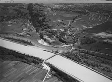
Villages, reeds and forests in the municipality of Gamprin |
Gamprin with an area of 6.188 km² is located in the Liechtenstein Unterland. The community is located in the hilly landscape west of the Eschnerberg and consists of the villages Gamprin and Bendern. In the south, Gamprin meets the Rheinau-Tentscha exclave of the municipality of Eschen and the Vaduzer and Schaaner Riet, in the east lies the municipality of Eschen and in the north Schellenberg and Ruggell . In the west, the Rhine forms the border with the municipality of Sennwald in the Swiss canton of St. Gallen .
Gamprin has an exclave with the so-called Nendler Berg western slope of the Three Sisters Massif . It is 72.38 hectares of community forest above Nendeln and Schaanwald .
Parish soil
Another community forest of 40.52 hectares is located on the Eschnerberg . Compared to other communities, Gamprin had a lot of reed land. Because the formation of a citizens ' cooperative was rejected in a community and citizens' vote in 2004, the former citizens' assets fell to the political community. Nevertheless, 62 homeowners still have the right to use land in the Riet . Like the other municipalities in the Unterland, Gamprin does not have any livestock inland. However, the municipality of Gamprin owns a Viehalp am Arlberg , the Alpe Rauz , which is around 7 km 2 larger than the municipality of Gamprins.
history
Witnesses from the Stone , Bronze and Iron Ages have been found in Gamprin . The important archaeological site of Lutzengüetle is located in the municipality.
From the Middle Ages to modern times, the ecclesiastical and manorial conditions of Gamprin correspond to those of the parish of Bendern . In 1499 it was pillaged by the Confederates . From 1622 to 1637, Gamprin was affected by troops and the plague during the Graubünden turmoil . The oldest surviving village order from 1643 described the rights and obligations of the villagers to use pastures and forests. From 1761 to 1822 the municipal boundaries were formed by dividing the common goods (meadows, floodplains, fields, forests) between Gamprin, Eschen , Ruggell and Mauren .
A Rheinmühle operated until 1927 was owned by the state rulers until the middle of the 18th century, then by Gamprin. The rights to the Rhine ferry Bendern – Haag were held by the Counts of Werdenberg , Glarus from 1517 to 1798 and, from 1803, the Canton of St. Gallen . The first bridge construction in 1867/68 meant the abandonment of the ferry. New buildings followed in 1895/96 and 1963–1965. Until 1923, a bridge fee was temporarily charged. In 1927 a devastating invasion of the Rhine occurred. After the Customs Treaty of 1923 , the Swiss share of the population increased from 2% in 1930 to 12% in 1989. In 1998 it was 10%. Agriculture and animal husbandry dominated until the middle of the 20th century. From 1955 to 1985 the number of farms fell from 61 to 16. The community owns the Alpe Rauz am Arlberg and, together with Ruggell, the cooperative Alpe Fahren -Ziersch in Vandans in the Montafon. With the settlement of a diverse trade and industry, the employment structure changed from 1955. In 2000 there were around 1,600 jobs in Gamprin, around three-fifths of them in the second economic sector .
coat of arms
 |
Gamprin had neither its own recognized coat of arms nor a municipal flag or municipal colors until 1950. All parishes were supposed to present themselves at the national celebration that year. Gamprin made do with the unrecognized coat of arms. At that time, the coat of arms still consisted of the symbols of the Bendern church, specifically the steps of the former roof and the church tower. In 1957, the local council decided to set up a commission to end this interim solution. The commission was given the task of designing a recognized coat of arms for the municipality of Gamprin-Bendern, as well as developing the associated municipality colors and flags.
The commission dealt intensively with the motive. The old name Gamprins - campus Rheni , which means something like field on the Rhine, served as the basis and guiding principle . The golden wavy band that runs through today's coat of arms (see right) is reminiscent of Gamprin's location on the Rhine. The historically significant part of the village of Bendern should also be reflected in the coat of arms . From the coat of arms of the knight Rüdiger von Limbach, owner of the old rectory and extensive estates, the two roses were included in the coat of arms. The proposal of the commission found the approval of the municipal council after heraldic propagation. One year later, in 1958, Prince Franz Josef II granted the municipality of Gamprin-Bendern the right to use coats of arms and flags by means of a coat of arms.
politics
The community leader has been Johannes Hasler (FBP) since 2019 . The council has nine seats: FBP with five and VU with four seats.
Attractions
- Marienkirche
- Oath place: on March 16, 1699, the men of the Unterland swore allegiance to the Prince of Liechtenstein for the first time.
- Unterländerbrunnen
- Marien grotto (pilgrimage site)
- Lotzagüetle with traces of settlement from the Neolithic Pfyn culture (approx. 4000 BC)
- Gampriner Seelein , a lake that was created naturally in 1927
Say
One of the most famous legends is the legend of the "Wild Gampriner Geissbock", which is about a farmer and his badly treated billy goat.
→ Section The Wild Gampriner Geissbock in the article Liechtenstein legends
leisure
In 2011 the “Grossabünt” leisure facility was opened. This facility is the venue for a Christmas swim, which took place for the third time in 2015.
photos

Church hill in Bendern

Village center with the community center bus stop
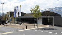
Community house (right) and community hall
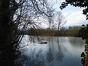
Gampriner lake

Gamprin owns the Alpe Rauz am Arlberg


literature
- Harald Wanger, Ulrike Mayr, Jürgen Schindler: Gamprin. In: Historical Lexicon of the Principality of Liechtenstein . December 31, 2011 .
Web links
- Gamprin Municipality website
- Arthur Brunhart: Gamprin. In: Historical Lexicon of Switzerland .
Individual evidence
- ^ Tables of population statistics. (XLS; 345 kB ) June 30, 2019. Statistical Office (AS), Principality of Liechtenstein, accessed on December 24, 2019 .
- ↑ population statistics. ( PDF ; 913 kB ) June 30, 2017. Statistical Office (AS), Principality of Liechtenstein, p. 15 , accessed on January 31, 2018 .
-
↑ a b c Arthur Brunhart: Gamprin. In: Historical Lexicon of Switzerland .
These sections are largely based on the entry in the Historical Lexicon of Switzerland (HLS), which, according to the HLS's usage information, is under the Creative Commons license - Attribution - Share under the same conditions 4.0 International (CC BY-SA 4.0). - ↑ Christmas swimming in Lake Gamprin, Liechtenstein Fatherland , article from December 13, 2015