
List of geographical centers
There are different calculation methods for determining the center of a country. Some are described in the article Center of Germany . You can determine the center of a country using different methods. There is no scientific, government-authorized definition. The indication of geographical centers is therefore more of a gimmick. This leaves a lot of room for different calculations, some of which differ remarkably from one another. Often they have a tourist significance because small places emerge from their anonymity and can set a monument in the center.
In addition to these geographic methods, there is also the
- Center of population , as the point to which all inhabitants of an area are on average the shortest distance (as the crow flies).
- Means of transport with the shortest route on average via public traffic areas from all points in the country, alternatively the route from all border towns.
- political, cultural, economic and / or social center, which rarely coincides with the national center.
Such calculations can definitely make sense when planning infrastructure or logistics .
The calculation of the center point is particularly controversial in states with various separate and distant parts of the country, such as B. USA ( Alaska , Hawaii ), Greece or Indonesia (island world), exclaves and enclaves as in Russia ( Kaliningrad in Poland / Lithuania) or United Kingdom / Spain ( Gibraltar ), overseas territories or distant islands ( Greenland , Canaries , Azores , South Georgia .)
This list should cover the earth , continents , large geographical units (e.g. Iberian Peninsula), communities of states (e.g. EU), states and their first level including ( federal states and equivalents (e.g. Lazio, England)) be limited.
Europe today


_-_panoramio.jpg)


.JPG)


Remarks
- ↑ Focus, without taking into account overseas territories (such as French overseas territories ) that are not part of the territory of the European Union. The French Départements et régions d'outre-mer (DOM-ROM) belonging to the territory of the European Union have, however, been taken into account in the determination.
-
↑ After the United Kingdom left the EU ( Brexit ) on January 31, 2020, the center shifted by almost 56 kilometers to the southeast. A corresponding position has now been created.
- Gadheim, 80 inhabitants, center of the EU - thanks to Brexit , April 4, 2017, Süddeutsche Zeitung
- Europe's new center has only 76 inhabitants , Die Welt 04.04.2017
- Veitshöchheim: Gadheim will be the new center of the EU , 03/30/2017, Bayernreporter
- Gadheim - the Bavarian hamlet set to become the center of a post-Brexit EU
- ^ To the northwest of Encamp parish
-
↑ The center of the Baltic region is located in the Ikšķile municipality about 2.3 km west of the village of Tīnūžu. Private houses are currently being built on the meadow. The closest houses are at Lejas Paegļi, about 120 m northeast. Interestingly, the Baltic center is just 2.4 km south of the geographic center of Latvia.
- Where is the Baltic? , Explanation in Latvian with photos
- ↑ To mark the center, a monument designed by the local architect Bernard Defrenne was erected approx. 239 m north of the Place du Tram (pedestrian zone, former train stop). It stands on a base that is supposed to represent the earth's crust and in which 12 lamps are embedded, which stand for the twelve EC states ( EC -12: up to and including 1994, not EU ). Three pillars, which symbolize the three regions of Belgium , carry a pyramid with a steel tube attached in the middle, which shows the center of Belgium. In front of it, three panels provide information in German, French and Dutch about the meaning of the individual parts of the monument. The inauguration took place on August 22, 1998 - strange, at that time the EU-15 already existed: up to and including April 2004 .
- ↑ between Travnik and Zenica
- ↑ Denmark has several central points, because the islands, possibly including Greenland , allow several calculations. The official center also takes the island of Bornholm into account .
- ↑ Inconspicuous stone at the foot of a tree against Nølevvej 5
-
↑ A current center is not known. With the diverse island world, a calculation should be difficult. It used to be Delphi as the center.
- When calculating the center point with an enclosing rectangle, the center would be in the Aegean Sea about 20 km east of Almirimi Beach on Süduboea .
- Seen in this way, Athens is also very close to the center.
- ↑ About seven kilometers northwest of Dunsop Bridge . There is no memorial or sign at the exact point. It's just a vague tuft of grass surrounded by peat bog. It was close to 100,000. BT phone booth set up with the note: “You are calling from the BT payphone that marks the center of Great Britain”. - Stuck in the middle with ewe
- ↑ In the calculation of the center of the northernmost point of Iceland was not taken into account: Kolbeinsey at 67 ° 8 '9 " N , 18 ° 41' 3" W . It is only a 0.009 hectare rock in the sea, but Iceland also defends it from the forces of nature to protect its territory , e.g. B. because of the fishing rights .
-
↑ The calculations from 1994 resulted in Ponte Cardona at the coordinates mentioned as “L'ombelicolo d'Italia”.
- ↑ European part (5.4%). The center is probably a little north of Novaya Kazanka
-
↑ The center of the area is a good 20 km away in southern foreign countries. Therefore, Zagreb or Biograd na Moru on the coast is often given as the country's center.
Equal to 4 resorts in Croatia not claim the center of the world to be- Gdje je središte svijeta? deutsch Where is the center of the world? , November 14, 2003, Josip Faričić GEOGRAFIJA.hr (Croatian)
- ↑ The geographical center of Latvia is in the municipality of Ikšķile about 3.3 km northeast of the village of Tīnūži. It is located on a meadow that is currently a building site for private houses. The closest house in the hamlet of Auriņi is 60 m to the southeast. The center is not marked. The interesting thing is that the geographical center of the Baltic is only about 2.4 km south.
- ↑ The calculations by "NeoGeo" show that the main focus of Latvia is in the municipality of Sintiu in the district of Ogre . It is located about 4.3 km southeast of the village of Samos in the municipality of Viršņukalns. The geographical center of Latvia is 23 km west of the Latvian center of gravity
-
↑ Il-Knisja tal-Madonna tal-Mirakli ( German The Church of Our Lady of Miracles )
- The Geographic Center of ... Austrian school portal
- Tal-Mirakli Chapel Lija Local Council
- Il-Knisja tal-Madonna tal-Mirakli ~ Lija ~ Kappelli Maltin
- ↑ The usual calculation would result in a point in Sweden as the center
- ↑ Inscription "Piątek - geometryczny środek Polski"
- ↑ The geographical center of Romania is located near the entrance to the town from the direction of Agnita (within the borders since 1945)
- ↑ European part of Russia: 23.16%; without annexed Crimea . Since the border with Asia is defined differently, an exact center can only be estimated.
- ↑ European part of Turkey: 3%
-
↑ Including Crimea
The center is 550 m north-east of the end of the village (gas station) on the right edge of the Central Street ( Ukrainian Центральна вулиця , formerly Lenin Street , Т-12-14 direction Lypnjaschka , Ukrainian Липняжка ) and is surrounded by a rock with an inscription, an information sign and marked three flagpoles - ↑ The center of Scotland, defined by the farthest point between the North Sea and the Atlantic, is south of Newtonmore in Glentruim. The point was previously marked by a stone by the Ordnance Survey and given a plaque that was stolen and not replaced. The Clan Macpherson Memorial is nearby.
Europe historically
| Center of | area | place | coordinate | Note | image |
|---|---|---|---|---|---|
| Prussia (1815) | Brandenburg | Dolgelin municipality of Lindendorf | Estimated: 52 ° 30 ′ N , 14 ° 27 ′ E |

|
|
| Kingdom of Saxony (from 1815) | Saxony | Lichtenberg / Erzgeb. near Mulda in the district of central Saxony | 50 ° 49 ' N , 13 ° 27' E | Geographic center of Saxony |

|
| Large company near Freiberg , Central Saxony district | 50 ° 58 ' N , 13 ° 17' E | Physical focus of Saxony | |||
| German Empire (1871-1918) | Brandenburg | Spremberg | 51 ° 34 ′ 19.5 " N , 14 ° 22 ′ 16.2" E |

|
|
| German Democratic Republic (1949–1990) | Potsdam district | Verlorenwasser / Weitzgrund | 52 ° 12 ′ 0 ″ N , 12 ° 31 ′ 0 ″ E |

|
|
| Federal Republic of Germany (1957–1990) | Hesse | Rennerod in the Westerwald | |||
| Herbstein ( Vogelsbergkreis ) | 50 ° 32 '18 " N , 9 ° 21' 41" E | ||||
| Yugoslavia (1945–1992) | Bosnia and Herzegovina | east of the village of Dautovci , Verbandsgemeinde Visoko ,
Zenica-Doboj Canton , Federation of Bosnia and Herzegovina , Bosnia and Herzegovina ; 15 km away from Sarajevo removed |
43 ° 57 '1.5 " N , 18 ° 10' 35.4" E | geographical center | |
| Europe in the Austro-Hungarian Empire | Border Germany Czech Republic | Tillenberg | 49 ° 57 '43.3 " N , 12 ° 29' 26.4" E |

|
|
| European Union (1995-2004) | Belgium | Viroinval | 50 ° 0 ′ 33 " N , 4 ° 39 ′ 59" E | Focus on Europe of 15 members |

|
| European Union (2004-2006) | Rhineland-Palatinate | Kleinmaischeid | 50 ° 31 '31 " N , 7 ° 35' 50" E | main emphasis |

|
| European Union (2007-2013) | Hesse | Sea wood | 50 ° 10 ′ 21 ″ N , 9 ° 9 ′ 0 ″ E | main emphasis |

|
| Austria-Hungary (1914) | Hungary | at Somogydöröcske , county Tab , County Somogy , Somogy | Estimated: 46 ° 35 ′ N , 18 ° 0 ′ E |
Remarks
- ↑ Mean values of the coordinates of the northernmost and southernmost as well as the easternmost and westernmost point of the country. The geographic center of the kingdom was determined in 1992 by the Dresden cartographer Hans Brunner.
- ↑ The center is in the urban area and is neither specifically designated nor marked.
- ↑ Directly on the B275 between Herbstein and the district Altenschlirf there is a large basalt block with a corresponding board inscription. The measured center point is about 120 m northeast on the field.
- ↑ From January 1, 2007 to June 30, 2013, the geographic center of the EU was in the southernmost part of Meerholz, in the middle of a field at the foot of the "Niedermittlauer Heiligenkopf". The Institut Géographique National had calculated the exact coordinates. On January 26, 2007, the Hessian European Minister Volker Hoff symbolically hoisted a flag of the European Union .
- ↑ Mean value of the coordinates of the northernmost and southernmost as well as the easternmost and westernmost point of the historical country
rest of the world
| Center of | area | place | coordinate | Hints | photo |
|---|---|---|---|---|---|
| America (double continent) |
|
Cuilapa , Santa Rosa | 14 ° 16 '44.7 " N , 90 ° 17' 57.8" W. | The center of North and South America |
|
| Asia (continent) |
|
Kyzyl , Tuva , South Siberia | 51 ° 43 ′ 30 " N , 94 ° 26 ′ 37" E | The obelisk stands on the banks of the Yenisei | |
| Saldam ( Russian Салдам ), Tuva, southern Siberia | 52 ° 28 '49 " N , 96 ° 5' 35.3" E |
|

|
||
| Africa |
|
Epéna (Likouala) , Likouala | 2 ° 4 '13.3 " N , 17 ° 3' 10.5" E | Geographic center | |
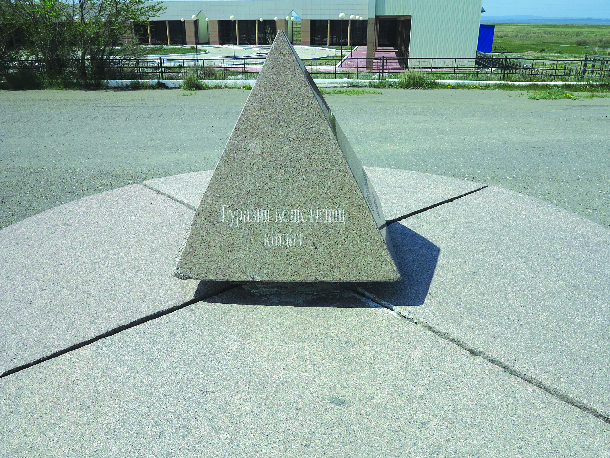
| Eurasia |
|
Shidebaj | 49 ° 7 ′ 18 " N , 79 ° 18 ′ 23.1" E | ||
| Nagpur | 21 ° 9 ′ 14 " N , 79 ° 4 ′ 59" E | ||||
|
( United States ) |
Stearns County | Sauk Center | 45 ° 44 ' N , 94 ° 57' W. | The city is considered the geographic center of the state | |
| South island | Nelson | 41 ° 16 ' S , 173 ° 18' E | Center for tourists |
||
| Spooner Range, Golden Downs | 41 ° 30 ′ 0 ″ S , 172 ° 55 ′ 0 ″ E | Inconspicuous but real focus |
|||
|
North America |
|
Rugby (North Dakota) | 48 ° 21 '16 " N , 99 ° 59' 53.1" W. |

|
|
|
|
Belle Fourche | including Alaska and Hawaii 44 ° 40 ′ 27.9 ″ N , 103 ° 51 ′ 9.9 ″ W, exactly 44 ° 58 ′ 0 ″ N , 103 ° 46 ′ 0 ″ W |

|
||
|
|
Lebanon | 39 ° 49 '42 .1 " N , 98 ° 34" 46.1 " W. | The 48 contiguous states only |
||
|
|
Wiwisee | 66 ° 24 '52.9 " N , 94 ° 14' 28.7" E | Calculated center point on the south bank of the Wiwisees. | ||
|
|
Karagandy | 25 kilometers south of Ulytau, near the river Zhezdy, Karaganda ;
90 kilometers from jezkazgan away |
48 ° 25 '54.5 " N , 66 ° 55' 13" E | Geographic center | |
|
- (islands off the mainland, within 100 km) |
|
39 ° 42 ′ 3.5 ″ S , 71 ° 5 ′ 4.6 ″ W. | Geographical centers
(Not located on the national territory) |
||
| - (with all islands, without Antarctic Territory ) | Pacific Ocean | 39 ° 42 ′ 3.5 ″ S , 81 ° 13 ′ 39.1 ″ W. | |||
|
|
Coclé Province | 8 ° 25 '38.4 " N , 80 ° 6' 19.5" W. | Geographic center | ||
|
|
Caribbean Sea | 13 km from the Gonâve Island away | 19 ° 3 ′ 29.8 " N , 73 ° 19 ′ 36.7" W. | Geographic center
(Not located on the national territory) |
|
|
|
Lower River Region | 1 km from the Gambia and Elephant Island ,
northwest of Bureng ; Jarra East , Lower River Region
|
13 ° 26 ′ 40.9 " N , 15 ° 18 ′ 27.1" W. | Geographic center | |
|
|
Cuvette-Ouest | 1km from the river Kouyou and the settlement Mboma and 20 km from Ewo away | 0 ° 40 '9.4 " S , 14 ° 54" 3.2 " E | Geographic center | |
|
|
Tchirozérine | 14 km from the settlement Tidene away | 17 ° 35 '48.8 " N , 8 ° 4' 49.4" E | Geographic center | |
| Lake Balaton | Veszprém county | at the Ifjúsági Centrum Kht. Ltp.im resort Zánka , county Balatanfüredi , Veszprém County , Central- ;
1 km from the lake shore |
46 ° 52 ′ 56.2 " N , 17 ° 42 ′ 23.1" E | (Is not located inside the lake) | |
| Intersection of the prime meridian and the equator | Eastern Atlantic Ocean 230 km southwest of the Gulf of Guinea |
0 ° N / S, 0 ° E / W |  |
.jpg)
|
|
| all land areas on earth |
|
Kıcıklar, Beyoğlan, İskilip , Çorum , Black Sea Region | 41 ° N , 35 ° E |
Center of the earth's surface , geometric center of gravity |
|


Remarks
-
↑ Cuilapa is the geographical center of the American double continent, of which a monument in the form of a large arch with the inscription CENTRO DE LAS AMERICAS “CUILAPA” reminds of the church “Catedral El Niño Dios” . Below is a schematic model of the double continent made of concrete, which can be viewed from a small bridge. In the meantime, the system looks very much in need of an overhaul. The Interamericana (CA 1), which connects Alaska with Tierra del Fuego with just a few gaps , passes the city.
- Journey to the Center of America , March 1, 2018, Guatemala - Time everyday and travel, the easy and hard way!
- City of Cuilapa (Santa Rosa)
- ↑ According to calculations by the then 25-year-old British researcher, geographer and world traveler Douglas Carruthers in 1910, the center is near Kyzyl. A stone with a corresponding inscription was later erected there. The sinologist and historian Otto Mänchen-Helfen said: "I saw this stone in the summer of 1929. It was in the village of Saldam in Tuwa." ( Journey to the Asian Tuwa . Verlag Der Bücherkreis, Berlin 1931). After 1929 this column was moved from Saldam a good 140 km southeast to Kyzyl and set up on the bank. This column was swept away by a flood, and only its stone base remained in the courtyard of the river shipping company for a long time. In 1964 a monument in the shape of a globe was erected on a two-meter high base with a triangular concrete obelisk at the beginning of Komsomolskaya Street. In 2014 the obelisk was completely replaced based on a design by the Buryat sculptor Daschi Balschanowitsch Namdakow. The delimitation of Europe and Asia with the Caucasus ridge instead of the Kuma-Manych lowland , which has now been preferred since Putin's reign , is likely to shift this center point again.
-
↑ A modest pyramid, which marks the center of Eurasia, stands in front of the former home of the poet Abaj. “Center of the Eurasian continent” is written in stone on the four side walls - in three major Eurasian lingua franca (Russian, Chinese, English) and one small (Kazakh).
- Pyramid: center of Eurasia in Zhidebaj ( Russian Жидебай )
- Photo from Kazakh «Көңіл құсы құйқылжыр шартарапқа…»
- Journey to the center of Eurasia See: “In the center of the continent: a pyramid”, by Hartmut Wagner , Eurasisches Magazin
-
↑ The center of India is in the urban area.
- India off the beaten track: Nagpur February 13, 2017, India News
- Geographical Information (on Nagpur city) ( Memento from November 13, 2012 in the Internet Archive )
- ↑ Nelson City is often referred to as the geographic center of New Zealand. This should be on the 147 m high Botanical Hill in the center of the city. A striking monument marks the place. However, it was only the base point for carrying out land surveys earlier. It is a popular destination with a fantastic view. The true geographic center is actually unmarked on the Spooner Range, Golden Downs, near Tapawera, about 35 kilometers southwest of Nelson
- ↑ The true geographic center is unmarked on the Spooner Range, Golden Downs, near Tapawera, about 35 kilometers southwest of Nelson.
-
↑ In 1931 a 4.5 m high obelisk was erected to mark the geographic center of North America. In 1971 the obelisk was re-erected at a different location after new measurements. But it is still controversial to this day whether the place can be called the geographic center of North America. The last measurements assume that the geographic center is about 25 km from the city
- The Geographical Center of North America , 18-Aug-2005
-
↑ The position of the marking is not entirely correct. It was installed to represent the real focus in the tourist center of Belle Fourche. The center calculated by the US Coast and Geodetic Survey is approximately 32 km north
- Geographical center of the USA , Michael Moll, Die Weltenbummler
- In the Middle of Nowhere, a Nation's Center
- ↑ This is the geographic center of the USA of the 48 contiguous states (excluding Hawaii and Alaska). A monument was erected for this in 1941.
- ↑ After verification by the State Office for Geodesy and Cartography, this was officially recognized. A 7 m high monument with an inscription was therefore erected there on August 21, 1992 . On the shore of the lake there is a wooden chapel of the Russian Orthodox Church and a cross, which were consecrated on September 9, 2006 in honor of St. Sergius of Radonezh (1319-1392). After the annexation of Crimea , another monument was erected a little further south.
-
↑ Contrary to some assumptions and publications, the equator and the prime meridian do not cross in the gulf, but around 230 km further southwest . According to the definition of the International Hydrographic Organization , it is bounded by Cape Palmas in Liberia and Cap Lopez in Gabon .
- International Hydrographic Organization (1953): Limits of Oceans and Seas, 3rd edition (PDF; 994 kB), p. 19. Accessed February 7, 2010.
-
↑ In the two-dimensional spherical surface with orthodromes as a measure of distance, according to Isenberg, 2003
The definition of Turkey is very controversial. Many see the center point at the Giza pyramids . Devout Muslims, also in Turkey, see the Kaaba in Mecca as the center of the earth.- Giza, center of the earth
- Calculating Centroid of all lands of Earth using SQL Server Spatial? StackExchange, Geographic Information System
- Gdje je središte svijeta? deutsch Where is the center of the world? , November 14, 2003, Josip Faričić GEOGRAFIJA.hr (Croatian)
Web links
- Collected geographical centers in Europe , "Die Weltenbummler", Michael Moll 2000–2019
Individual evidence
- ↑ Brief fame, Tagesspiegel of December 30, 2016
- ↑ Mandri-Eesti keskpunkt
- ↑ a b Geographical Facts and Figures
- ↑ Gjeografia] , KPMM komisioni i pavarur për miniera dhe minerale, Kosovo
- ↑ Lietuvos geografiniai ekstremumai ( lt ) Nacionalinė žemės tarnyba prie ŽŪM.
- ↑ Pico da Melriça: Aqui é o centro de Portugal?
-
↑ Center of Scotland
Stone markinh the Center of Scotland
The Geographic Center of Scotland
In pictures: The center of Scotland
Brave hearts of Scotland
Highland Town Proudly Claims to be the Center of Scotland
Center of Scotland Stone Dedication