
Center of Europe
Several regions or localities consider themselves to be the geographical center of Europe . Since there are different methods for calculating the center point, several places claim the title for themselves; furthermore, the borders between Europe and Asia are not clearly defined. These are more curiosities of tourist and possibly political relevance than serious science.
Geographical center of the continent of Europe
Historical calculations
- Poland
As early as 1775 the Polish cartographer and astronomer Szymon Antoni Sobiekrajski calculated the town Suchowola in Poland as the geographical center of Europe. A large boulder with an inscription indicates this in the center of the village.
![]()
- Austria-Hungary (Czech Republic, Bavaria, Ukraine)
Geographers from the Austro-Hungarian monarchy calculated the 939 meter high Tillenberg ( Czech Dyleň ) near the Bohemian city of Eger ( Czech Cheb ) in the Czech Republic as the geographical center of Europe . At that time they documented this on a copper plate that they attached to the summit. The nearby town of Neualbenreuth still uses this fact today for its tourism advertising. The official BayernAtlas shows the center of Europe on the Bavarian side of the border in the triangle Neualbenreuth - Tillenberg - Schopf .
![]()
Since there were other villages, the awards for this property were editors of the consignment Bavaria, where it knows hardly any of the Bayerischer Rundfunk the center of Central Europe remeasured years ago. The Institute for Geography at the University of Munich , which carried out the order, came to the conclusion that the center point is to be found a little further south, namely in Hildweinsreuth near Flossenbürg (Germany) in the northern Upper Palatinate . The geographical delimitation of Central Europe is, however, controversial.
![]()
In 1887 , a place near Rakhiv in the Ukraine , the village of Dilowe , when the region was part of the dual monarchy, was “determined with great care” as an “eternal place” ( Latin locus perennis ). There were a total of seven similar marker stones in Central Europe, which served as fixed points for measuring heights, lengths and widths of the Habsburg Empire . None is designated as the center of Europe. This stone was created in connection with the surveying work carried out for the construction of the Rakhiv – Sighetu Marmației ( Hungarian: Máramarossziget ) railway line . In the course of this work, the engineers allegedly established that they had measured the geographical center of Europe. There is no contemporary source for confirmation. Allegedly, Viennese scientists confirmed this thesis after thorough examination. In 1887 a two meter high geodetic monument made of concrete was erected, the original of which has been preserved to this day. Presumably, the measuring point was later declared the center point for local patriotic motives and marketed as a destination.
![]()
The place is marked with a plaque with (incorrect) Latin inscription:
|
LOCUS PERENNIS DILICENTISSIME CUM LIBELLA LIBRATIONIS QUAE EST IN AUSTRIA ET HUNGARIA CONFECTA CUM MEN- SURA GRADUM MERIDIONALIUM ET PARALLELORUM QUAM EUROPEUM MDCCCLXXXVII |
The symbolic monument survived two world wars and the Soviet system in its original form to our present day. Since the geodetic mark as the center symbol appeared very modest, a modern, 7.20 meter high stele has stood next to it since May 27, 1977, the parallel lines of which symbolize the four sides of the world. A sphere that symbolizes the planet earth is at a height of 6.60 meters. In addition to its symbolic value, this sphere also has a stabilizing effect on the divided stele. The neighboring place on the bridge is a popular destination for tourists.
- German Empire
Around 1900 geographers of the German Empire calculated a place near the Frauenkirche in Dresden as the center of Europe.
- Slovakia
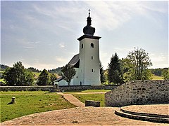
Other candidates for the center of Europe are the places Kremnické Bane (formerly German Johannesberg ) near Krahule (German Blaufuss) and the city of Kremnica ( German Kremnitz ) in central Slovakia .
![]()
- Czech Republic
A hill Volyně near Čečelovice ( German Tschetschelowitz ) and a memorial northeast of Budweis in the Czech Republic are designated as the center of Europe.
- Belarus
Even earlier, places in what is now Belarus were given as the center of Europe. Was reported Wizebsk in the Northeast and about 50 kilometers north-west of Babrujsk at 53 ° 33 '54.7 " N , 29 ° 21' 32" O in Mogilev Region .
![]()

Boulder at the geographical center of Europe in Suchowola, Poland (based on calculations from 1775)

The Tillen ( Dyleň ) as the center of Europe according to calculations by Austro-Hungarian geographers

Memorial stone to the center of Europe on the Tillenberg near the Czech border
Church of St. John and center of Europe in Kremnické Bane

Center Point Monument in Kremnické Bane


.jpg)


Recent calculations
- Lithuania (after the Institut géographique national)

In 1989, geographers at the Institut géographique national , the national geography institute of France, calculated the geographical center of Europe as the area's center of gravity and determined a location near the village of Purnuškės a little north of Vilnius in Lithuania with the coordinates 54 ° 54 ′ 0 ″ N , 25 ° 19 ′ 0 ″ E .
These data were only determined after the new delimitation of Europe as a continent: North: Svalbard , South: Canary Islands , East: Ural Mountains , West: Azores . The borders of the continent are the Kara River , the highest ridge of the Ural Mountains, the Ural River , the Caspian Sea to the Abşeron Peninsula , the highest ridge of the Caucasus to the mouth of the Kuban , the Black Sea through the Bosporus , along the Dardanelles , the eastern islands of Greece along the Turkish coast of the Aegean Sea , the Mediterranean Sea and Gibraltar . The institute performed all the calculations in three dimensions on an ellipsoidal cap. Thus, the calculated center is 180 km below the earth's surface and 6,200 km from the center of the earth.
The first marker, a square slab of black granite, was created at. At this point there is now a sundial and in the immediate vicinity there is now a compass rose on the ground and a high granite column with a wreath of stars as a destination for tourists. Overall, the facility is very spacious and representative. The actually calculated center of Europe is 762.4 m SSW-east in the forest and can only be reached with great difficulty. In 1991 the sculptor Gintaras Karosas founded the sculpture park “ Europos Parkas ” in neighboring Joneikiškės . To this end, he created a pyramid, around which stone slabs point to the surrounding countries and cities of Europe. Other artists have immortalized themselves here with works on the subject of Europe.
![]()
- Hungary
A calculation from 1992 showed that the geometric center of Europe is in the Hungarian village of Tállya . In 2000 a bird sculpture with a plaque was erected in the center of the village, declaring the place the “geometric center of Europe”.
![]()
- Belarus

In 2000, the scientist Alexei Solomonov and Waleryj Anoschko from published Belarus a study showing that the geographical center of Europe 48 km southwest of Polotsk ( Belarusian Полацк ) near the Scholars Lake ( Belarusian воз. Шо ) in the hamlet Ivies ( Belarusian Івесь ) in Vitebskaya Woblasz . The scientists used a special calculation basis that Europe assumes as a single whole - the North and Baltic Seas, the White Sea , the British Isles and the inland seas are considered part of the continental area. Scientists from the Russian Central Research Institute for Geodesy and Cartography in Moscow confirmed the admissibility of this approach and the correctness of the calculations a little later. So far, only the holiday complex "Agrousadyba Tsentr Evropy" ( Belarusian Агроусадьба Центр Европы ) in the village indicates this fact.
![]()
On May 31, 2008, a memorial stone was inaugurated in Polatsk city center . However, a sign shows the coordinates of a point about 2.5 km northwest of the memorial stone on private property on the outskirts of Polatsk . Furthermore, the "geographical center of Europe" is indicated in five languages: to the north in Swedish, to the east in Russian, to the south in Greek and to the west in English. In the middle circle is the information in Belarusian.
![]()
![]()
- Estonia
If all European islands - from the Azores to Franz Josef Land and from Crete to Iceland - are taken into account, the center of Europe is at 58 ° 18 ′ 14 ″ N , 22 ° 16 ′ 44 ″ E on private property Mõnnuste village on Saaremaa island in western Estonia . An author and the calculation method for 2008 have not yet been given. The local municipality of Kärla is trying to confirm the location in order to make it a tourist destination.
Central points of Europe according to historical and current calculations |

Geographical center of the European Union
Central points of the EU from 1995 Large map: Germany Small map: Belgium |


Historical centers of the European Union
The French Institut national de l'information géographique et forestière (IGN, until December 31, 2011 Institut géographique national) identified the following localities for the center of the European Union :
Between 1995 and 2004, the center of the European Union was near the Belgian town of Viroinval . Due to the eastward expansion of the EU on May 1, 2004, Kleinmaischeid near Neuwied with the coordinates 50 ° 31 ′ 31 ″ N , 7 ° 35 ′ 50 ″ E was the geographical center of the European Union until December 31, 2006. On October 10, 2004, a memorial stone was inaugurated on this occasion, showing a circle.
![]()
Instead, the Institute for Theoretical Geodesy in Bonn determined that the center of the European Union after its enlargement in 2004 lies on the coordinates 50 ° 51 ′ 10 ″ N , 8 ° 46 ′ 43 ″ E. This point is located on the Kaschubenweg in Cölbe and was marked by a metal plate.

Between the sixth eastward enlargement of the EU in 2007 and Croatia's accession, the center of the European Union was in the Hessian city of Gelnhausen , in the Meerholz district . The Institut Géographique National had calculated the exact coordinates 50 ° 10 ′ 21 ″ N , 9 ° 9 ′ 0 ″ E. A three-ton sculpture made of red sandstone marks the former geographic center of the European Union. Seven artists from the region designed the object together. The centerpiece of the sculpture on a cornfield on the edge of sea wood is a hollow body made of red sandstone. Sand and earth from the 27 member states of the EU were gradually poured in there. The Hessian European Minister Volker Hoff (CDU) brought earth from Hungary to the one-hour opening ceremony with 300 guests . A brass lid with an engraved dove of peace closes the sculpture. 26 lines carved into the stone show visitors in which directions the other EU countries are. The country codes of the EU member states can be read on a metal ring attached to the side of the stone .

Since Croatia 's accession to the EU on July 1, 2013, the geographic center of the EU has been in the district of Aschaffenburg , in the Oberwestern district of the Bavarian municipality of Westerngrund. By joining the French overseas department of Mayotte , an archipelago northwest of Madagascar , it has increased by another 500 m moved . This point is also a geodetic reference point .
![]()
![]()
Current geographical center of the European Union
Since the UK left the EU on January 31, 2020, the geographic center of the EU has been in the district of Würzburg , in the district of Gadheim, municipality of Veitshöchheim near Würzburg.
![]()

See also
Web links
- Documentation Die Mitte by Stanislaw Mucha on the search for the center of Europe
- Chris Tomas: Centrally located - where is the center of Europe? In: World of Wonders at Yahoo. Yahoo, accessed July 18, 2012 .
- Peter-Philipp Schmitt: Central outskirts - Kleinmaischeid in the Westerwald should be the geographical center of the enlarged EU. In: FAZ , April 27, 2004
- Center of Europe Lithuania for (almost) everything about Lithuania!
Individual evidence
- ↑ The center of Europe in the Bavaria Atlas
-
↑ Finding the Middle , Lufthansa Magazin;
Jens Mühling : Black Earth. A trip through Ukraine. Rowohlt Publishing House. - ↑ Geographical center of Europe in Transcarpathia ( Ukrainian Географічний центр Європи на Закарпатті ).
- ^ Jan S. Krogh: Jan S. Krogh's Geosite: Places of Interest. In: geosite.jankrogh.com. 2001, accessed March 3, 2020 .
- ↑ Tállya nevezetességei »Közterületi szobrok» Európa mértani középpontja (Hungarian, several photos)
- ↑ Где ты, географический центр Европы? (No longer available online.) October 11, 2017, archived from the original on January 15, 2018 ; Retrieved January 7, 2018 (Russian). Info: The archive link was inserted automatically and has not yet been checked. Please check the original and archive link according to the instructions and then remove this notice.
- ↑ Kärla vald tahab Euroopa keskpunkti külalistele avada (Estonian)
- ↑ Le center geographique de l'Europe des 25 calculé par l'Institut Géographique National. Archived from the original on July 13, 2007 ; Retrieved January 3, 2007 .
- ↑ Le nouveau center de l'Europe. In: IGN. January 4, 2007, archived from the original on July 17, 2007 ; Retrieved March 2, 2007 .
- ↑ The EU's new center is in southeast Hesse. In: Rhein-Zeitung. January 3, 2007, accessed January 4, 2007 .
- ↑ Where is the center? In: Manager-Magazin , July 9, 2007
- ↑ Center of the European Union. ( Memento from January 1, 2011 in the Internet Archive ) In: mkk.de , November 27, 2007
- ^ Frank Müller: Western reason (Lkr. AB): The center of Europe in Franconia. ( Memento from February 22, 2014 in the Internet Archive ) Radio reportage, Bavaria 2, regionalZeit - Franconia.
- ↑ Westerngrund is the center of the European Union
- ↑ The center is a damp meadow in Oberwestern. In: main-netz.de
- ↑ New center of Europe: Westerngrund in the Aschaffenburg district replaces Meerholz. In: Frankfurter Allgemeine Zeitung , July 3, 2013, No. 151, page 45.
-
↑ Gadheim, 80 inhabitants, center of the EU - thanks to Brexit in: sueddeutsche.de
Veitshöchheim: Gadheim will be the new center of the EU 03/30/2017 Bayernreporter