
Center of Austria

|
The center of Austria represents the place that is geographically in the middle of Austria .
Calculation methods
The geographical center of a country can be determined using different methods. A frequently used method is the computational determination of the geometric center of gravity of a two-dimensional map model of the country. This can also be determined purely mechanically, by balancing a cut-out map or by attaching it to two suspension points and determining the intersection of the two resulting lines of gravity.
Another method is the calculation of the arithmetic mean values of the longitudes of the westernmost and easternmost point as well as the latitude of the southernmost and northernmost point of an area. This center point corresponds to the intersection of the two diagonals of a rectangle which encloses the area. That's in Austria in close to Konigsberg Horn in the municipality of St. Gilgen at 47.6964 ° N , 13.3458 ° O .
A rare method is the determination of the place which is furthest inland from any point of the national border, the pole of inaccessibility . This is in Austria at the entrance of Gesäuse , in the municipality of Admont at 47.5783 ° N , 14.5525 ° O .
What all methods have in common is that they are based on a two-dimensional map model. And depending on the map projection used for this, this will lead to different results despite the same calculation method.
history
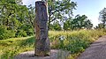
The Große Österreich Illustrierte organized a competition in 1949 which asked the participants to determine the center of Austria. The “winners” were offered free vacations, which were a special luxury at the time. After mechanical determination of the center of gravity, several residents of Bad Aussee stated that they lived in the center of Austria. The illustrated magazine confirmed (according to a report by the University of Vienna) these claims: “ Bad Aussee is the center of Austria.” On September 24, 1949 the official celebrations took place, in which the actress Maria Andergast was also involved. In 1989, the market town of Bad Aussee took the 40th anniversary of the festival as an opportunity to once again highlight the location in the heart of Austria with a series of events. This can include the "center stone" in the spa park in was 47.6091 ° N , 13.7844 ° O unveiled. A memorial, which is supposed to bring the focus to the attention of the residents and tourists. A bronze disk was placed on top of this monument to symbolize the center. This piece of metal is called "Omphalos" (Greek for navel ) based on the stone of the same name from ancient times .

Center stone in the Bad Aussee spa park

Information board at the center stone


In contrast to the determination from 1949, the geometric focus of Austria was calculated in 2005 with the help of computer-aided border files for the development of a geocache. In 2019, site-specific source data from the Federal Office for Metrology and Surveying was used for the first time . Based on this calculation, the geographic center of Austria is at an altitude of 1380 m above sea level. A. at 47.59397 ° N , 14.12456 ° O . This means that the focus is on a mountain slope in the municipality of Stainach-Pürgg , about 800 m north of the Bärenfeuchtmölbing summit and about 25 km east of the city center of Bad Aussee .
Since there is no binding demarcation through Lake Constance , the normally usual demarcation in the middle of the water body was used.

Summit of the Bärenfeuchtmölbing, near the center point

At Bärenfeuchtmölbing, view of the Bärenfeuchtenalm

Panorama at Bärenfeuchtmölbing, direction northeast

Panorama at Bärenfeuchtmölbing, towards Aigen im Ennstal

Panorama at Bärenfeuchtmölbing, towards Dachstein


Centers of the federal states

Burgenland
The geographical center of the castle country lies in the community frankenau-unterpullendorf in the district Unterpullendorf at 47.4781 ° N , 16.5716 ° O . It is the arithmetic mean of the northernmost, easternmost, westernmost and southernmost point of the state. A memorial called the "center stone" marks the site. This basalt stone from Pauliberg was erected in 1991 by the Burgenland Geographers Society on the occasion of "70 years of Burgenland".

Center stone in Frankenau-Unterpullendorf
.jpg)
Carinthia
The center of Carinthia, in the town of Arriach at 46.7525 ° N , 13.8617 ° O to find and is a popular destination for hikers is. This is to the arithmetic mean of northernmost, easternmost, westernmost and southernmost point of the state . Directly at the center is a red concrete platform, based on the Arriach logo, with the coordinates and provided with a metallic cross. Visitors can take photos of their visit using a permanently installed webcam.

The Arriach logo symbolizes the center of Carinthia

Platform and resting place at the center

Webcam at the center point

Information board


Lower Austria
The center of Lower Austria is on the outskirts of the market town Kapelln in the location Oberkilling at 48.2702 ° N , 15.7651 ° O to find. The Max-Schubert-Warte observation tower was built on this in 1993 . It is located in the focus of the external borders of Lower Austria, the internal borders around Vienna, however, were not taken into account. An adventure trail that starts in Kapelln by the church and leads to the control room tells in 12 interactive stations about the history of Lower Austria, about legends and customs, mountains and records.

Monument at the center of Lower Austria

Information board

Poem at the control room

Music benches by the control room


Upper Austria
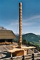
The geometric center of gravity of Upper Austria is located in the town of Gunskirchen at 48.1366 ° N , 13.9644 ° O . It was calculated for the first time in 2005 to develop a geocache, and in 2011 it was officially confirmed by the state of Upper Austria in the same place and marked with a wooden stake. In 2013, a carved wooden monument was erected 170 m northeast of the arithmetic center. On the side of the province of Upper Austria, you can also show the center points of each district on a map.

Wooden sculpture near the center
The location of the sculpture is on the edge of a Kuhschellen meadow

Information board


- Grieskirchen district
- On the occasion of the 100th anniversary of Grieskirchen , the geographical center of the Upper Austrian district was calculated. The center stone is set in the village of Eibelhub in the town of Taufkirchen , near the municipal border with Pötting at 48.2697 ° N , 13.7693 ° O .
Salzburg
The geometric focus of the province of Salzburg is located in Mühlbach at 47.3878 ° N , 13.0858 ° O . In 2004 a wooden sculpture was erected on the Karbachalm sun terrace (1.2 km south of the center). A table made of larch wood with the shape of the state of Salzburg and an approx. 9 m high wooden trunk with the municipality's coat of arms and 119 windows (symbolize all Salzburg municipalities). Another wooden sculpture was erected on the Dientner Sattel on the Dientalm (2.2 km west of the center). Another sculpture was originally planned at the computational center. In 2012 the sculpture on the Karbachalm was dilapidated and finally dismantled due to lack of financial support. Today part of the coat of arms tree is on the property of Sepp Gamsjäger, at the entrance to Mühlbach.

Karbachalm with the wooden sculpture
Heraldic tree


Styria
The geometric focus of Styria, in the village of St. Stefan ob Leoben approximately 1.1 km southeast of the Walteralm at 47.2696 ° N , 15.0137 ° O . In the immediate vicinity of the center there is a wooden table with a bench, an information board and a metal post with a board with the inscription "Geographical Center of Styria".

Metal marking at the exact center

Rest area near the center

Information board

View from the rest area


- Graz
- The centroid of Graz is located in the Paulustorgasse at 47.0743 ° N , 15.4401 ° O . For this purpose, the sculpture "Grazer Stadtkern" was set up in a bank branch there in 2001, a 40 cm large object made of bronze and steel that is reminiscent of a peach core. After the bank branch was no longer generally accessible, the sculpture was set up in a new location, namely at the arithmetic mean of the northernmost, easternmost, westernmost and southernmost point of the city. This is in the courtyard of Graz Castle at 47.0729 ° N , 15.4427 ° O .

Graz city center
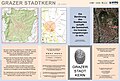
Information board


Tyrol
Since the federal state of Tyrol consists of two separate sub-areas ( North Tyrol and East Tyrol ), a center point can be determined for the total area as well as for each sub-area.
- Entire State: The focus is in the municipality elbows at 46.1962 ° N , 11.5021 ° O
- North Tyrol: The focus is in the municipality Völs at 47.2503 ° N , 11.3066 ° O
- East Tyrol: The focus is located in Hopfgarten in Defereggen at 46.9061 ° N , 12.5228 ° O . 600 m east of the center of gravity on the ridge of the Firstkogel, the borders of East Tyrol were handcrafted in miniature with the help of fences and provided with five entrances. These gates are supposed to symbolize the five traffic connections to the outside.
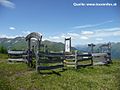
Fenced area at the East Tyrolean center

Information board at the East Tyrolean center


Vorarlberg
The focus is located in the town of Sonntag (Vorarlberg) , about 400 meters north of the parish church at 47.2412 ° N , 9.8943 ° O . For the border through Lake Constance, the usual borderline in the middle of the water was chosen.
Vienna
The centroid of Vienna is loud MA14, the operator of ViennaGIS in which Bäckerstraße at the level of the "Hall of Sciences" at 48.2084 ° N , 16.3778 ° O . The center point on the arithmetic mean value of the northernmost, easternmost, westernmost and southernmost point is located on the other hand based on the southern tip of Augartens at 48.2203 ° N , 16.3801 ° O .
Historical centers
Austria-Hungary (1914)
Since the borders of Austria-Hungary changed over the years , the geographical center of the former dual monarchy also shifted. In 1914 this place was in what is now Hungary , not far from Somogydöröcske, in Somogy County . This center point also represents the mean value of the coordinates of the northernmost and southernmost, as well as the easternmost and westernmost point of the historical country.
See also
- Center of Europe
- Center of Switzerland
- Center of Germany
- List of geographical centers
- Center of population
Web links
Individual evidence
- ↑ a b c d e Geographical centers in Austria
- ^ Bad Aussee, the geographical center of Austria | austria-forum.org
- ^ Geographical center of Austria | geocaching.com
- ↑ Best of Burgenland - Unterpullendorf
- ^ Arriach - art project at the center of Carinthia
- ↑ Max-Schubert-Warte erected | meinviertel.at
- ↑ Center of Lower Austria
- ↑ Hoamatland's Heart | geocaching.com
- ↑ An unequal race to the center of Upper Austria | nachricht.at
- ↑ The navel of Upper Austria is now properly marked | nachricht.at
- ↑ midpoints of each upper District | doris.at
- ^ District May worship at the geographical center of the district of Grieskirchen | meinviertel.at
- ^ Sculptures in Mühlbach am Hochkönig
- ↑ The lost center of Salzburg | derstandard.at
- ^ Mühlbach in the Middle | hochkoenig.at
- ↑ Centroid of Styria | geocaching.com
- ↑ Graz has a new city center | diesteirische.at
- ↑ Governors unveil the new city center of Graz
- ↑ The center of East Tyrol | geocaching.com
- ↑ Main area of Vienna
- ↑ That is the real center of Vienna | derstandard.at
- ↑ Danube Monarchy Austria-Hungary (mean values of the coordinates given there)