
Central points of Germany


As the center of Germany , a location is designated, the - determined according to different methods - in the middle of Germany is located.
You can determine the center of a country using different methods. There is no scientific, government-authorized definition. The indication of geographical centers is therefore more of a gimmick. This leaves a lot of room for different calculations, some of which differ remarkably from one another. Often they have a tourist significance because small places emerge from their anonymity and can set a monument in the center.
One of the possible definitions calculates, for example, the center of gravity of a two-dimensional map model. The calculated results lead to points in western Thuringia , but also in south-eastern Lower Saxony or in eastern Hesse in the city triangle of Kassel - Erfurt - Göttingen . The center of Germany shifted with the border changes of the Versailles Treaty in 1918 and the loss of the Eastern Territories in 1945, as well as with German reunification in 1990.
Calculation methods
| method | Place / location | position | Location sketch | image | |||
|---|---|---|---|---|---|---|---|
| Center of an area delimited by latitude and longitude | If you fit the borders of Germany into an area between the extreme latitude and longitude, the center point is at the intersection of the mean values of the coordinates of the northernmost and southernmost and the easternmost and westernmost point. | Niederdorla ( Vogtei municipality , Unstrut-Hainich district in Thuringia ) |
51 ° 9 '48.1 " N , 10 ° 26' 51.7" E |
 |

Commons : Center of Germany (Niederdorla) - Collection of images
|
||
| Intersection determination | If you connect the northernmost point of Germany and the southernmost point with a line and thus cross the connecting line between the easternmost and westernmost point, then the intersection of the extreme points results in the desired center point. | 2 km west of the village of Besse near Kassel (Hesse) | 51 ° 13 '15.3 " N , 9 ° 21' 27.3" E |

|

Commons : Center of Germany (Besse) - Collection of images
|
||
| Determination of the center of gravity | Another method of determining the center point is to find the geometric center of gravity . | ||||||
| through balance |
If you balance an area of any size from the shape of Germany , you get a center point. |
Niederdorla ( Vogtei municipality , Unstrut-Hainich district in Thuringia ) | 51 ° 8 ′ 0 ″ N , 10 ° 25 ′ 0 ″ E |
|

|
||
| Calculation for the national territory on land |
The exact calculation of the center of gravity of the area of Germany without a twelve-mile zone | Good land dispute |
51 ° 0 ′ 22.6 " N , 10 ° 20 ′ 11.4" E or 50 ° 57 ′ 58.5 " N , 10 ° 18 ′ 22.6" E |
|
|||
| Calculation for the entire national territory on water and on land |
For the calculation of this center of gravity of Germany, the twelve-mile zone of the territory in the North and Baltic Seas was also included. | Dingelstädt - Silberhausen ( Eichsfeld District , Thuringia ) |
approximately 51 ° 18 ′ 34 " N , 10 ° 20 ′ 21" E |
|
|||
| Calculation by 3D model |
This center of Germany was determined with the help of a three-dimensional model. Bumps in the form of polygons are also used to define it . |
Krebeck ( District of Göttingen , Lower Saxony ) |
51 ° 35 ′ 26 ″ N , 10 ° 6 ′ 22 ″ E |
|

Commons : Center of Germany (Krebeck) - Collection of images
|
||
| Minimum distance to the state border | This center point represents the point for which the sum of the distances to evenly distributed points on the state border is smallest.
Commons : Center of Germany (Flinsberg) - Collection of images
|
Heiligenstadt-Flinsberg ( Eichsfeld District , Thuringia ) |
51 ° 18 ′ 50.9 ″ N , 10 ° 11 ′ 16.7 ″ E also 51 ° 19 ′ 42 ″ N , 10 ° 11 ′ 0 ″ E |
|

Commons : Center of Germany (Flinsberg) - Collection of images
|
||
| Center of population | The center of the population is a place to which all residents of Germany have the shortest route on average. | near Spangenberg in Hesse | 51 ° 6 ′ 57.6 " N , 9 ° 42 ′ 10.8" E |
|
|||
| Determination by means of simple geometric figures | |||||||
| Enclosing rectangles | Points of intersection of the center lines or diagonals of the enclosing rectangles with a rotation of 0 ° or 45 °. | ||||||
| Outside and inside circle | Centers of the smallest outer circle and largest inner circle. | ||||||
| Padding squares | The measuring area is filled with squares, the area of the squares is weighted and the center is calculated from this. | ||||||


Problem
A country like Germany is relatively clear, but problems arise when calculating the center point:
- Establishing the state border
- As a rule, this results from agreements with neighboring countries and a mutually agreed border course, which is visible through boundary stones.
- The Bodensee is a condominium without fixed boundary. This could result in deviations. Alternatively, the center of the lake is used in calculations.
- The islands belonging to Germany are national territory, but do not belong to the mainland. Peninsulas are assigned to the mainland and islands connected to the mainland such as Usedom , Rügen , Fehmarn , Sylt , and some Halligen , are sometimes calculated as peninsulas.
- The other German islands in the Baltic Sea and North Sea ( North Frisian and East Frisian Islands , Helgoland ) are included either in the context of the coastal waters ( twelve-mile zone ) or according to other mathematical methods.
- The map display has problems. The Mercator projection that is most commonly used distorts the globe in the interest of keeping the correct angle . In doing so, circles of latitude and meridians become straight lines. Surfaces are stretched by the projection onto the now parallel meridians in an east-west direction, the further north, the more. If you cut out a typical Mercator map at the borders in order to balance the center, the north has a clear preponderance, which shifts the center to the north.
- The distance between two degrees of longitude on the northernmost degree of latitude in Germany is approx. 64 km and on the southernmost degree of latitude approx. 76 km, i.e. a difference of 12 km per degree. The distance between two latitudes is a constant 111 kilometers.
- At most, maps with true-to-length cone projection are suitable, but they are not commercially available. Here one could make do with a section of the globe.
Remarks
- ↑ (55.0585 + 47.27011) / 2 = 51.164305 , (5.866316 + 15.041925) / 2 = 10.4541205 - corresponds to 51 ° 9 ′ 51.5 ″ N , 10 ° 27 ′ 14.8 ″ E
- ↑ About 500 meters north of the core town of Niederdorla and about 1000 meters east of the former train station in the district of Oberdorla
-
↑ The point with the found / calculated coordinates in a corridor labeled "Rieth" with the map characters "Nasse Wiese" in sheet 4828 of the topographic map 1: 25,000 Oberdorla (measuring table sheet series, 1953 edition). 200 m to the west-southwest, next to a specially planted linden tree, an information board was placed on a striking stone about this central point of Germany. With the neighboring sacrificial moor Niederdorla , the area was already developed for tourism and is the most visited center.
Mühlhausen is only five kilometers north and is thus the central city and Erfurt (45.50 km; southeast), Göttingen (54.00 km; north-northwest) and Kassel (67.50 km; northwest) are the three large cities that are closest to the geographic center of the Federal Republic of Germany (all distances as the crow flies ).
Initiated by the mdr broadcast “ Outsider Front Runner” , this calculation was carried out by Heinz Finger in 1998 from the Institute for Geodesy at TU Dresden . Years earlier he had already measured the center of the GDR .- Focus on "Germany". (PDF; 12 kB) on: mittpunkt-deutschlands.de
- Center of Germany : Niederdorla
-
↑ Extreme points:
northernmost 55 ° 3 ′ 30.6 ″ N , 8 ° 25 ′ 6.2 ″ E elbow near List on Sylt 
southernmost 47 ° 16 '12.4 " N , 10 ° 10' 42" E boundary stone 147, Haldenwanger Eck near Einödsbach near Oberstdorf 
Easternmost 51 ° 16 ′ 22.4 ″ N , 15 ° 2 ′ 30.9 ″ E in the Neißebogen between Zentendorf and Deschka 
westernmost 51 ° 3 '4 " N , 5 ° 51' 58.7" E near Isenbruch , Selfkant , North Rhine-Westphalia 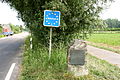
-
↑ Determination of the center of gravity according to Archimedes
An important mathematician of antiquity, Archimedes of Syracuse (287 to 212 BC) developed a mathematical procedure to determine the center of gravity of a surface arithmetically. He formulated two principles for this:- Every mass distribution has exactly one center of gravity.
- The center of gravity of a triangular patch is the intersection of the bisector .
Following these principles, Germany is divided into a network of adjacent triangles ( triangulation ), the individual triangular focal points are determined and they are weighted according to their area sizes. The arithmetic mean is then calculated from the weighted centers of gravity. The center of gravity obtained with this scientifically recognized method represents the geographical center. It can be illustrated in a simple way: for this, the land area cut out from a map sheet is used. The model is hung up one after the other at any points A and B on the edge of the model together with a plumb line. The respective plumb lines intersect at the center of gravity.
- ↑ This experimental method is very clear because it can be tried out quite easily and by almost anyone. Only geodesists and cartographers could be skeptical of the test, as a topographic map is cut up for it. It is glued to a firm surface (e.g. cardboard) and cut out precisely along the national border. The model is moved on a sharp needle until it is exactly in balance and aligned horizontally. This approximate focus can be interpreted as the geographical center of Germany. The approach assumes that Germany is a flat area. this method is problematic because the majority of the cards to be used are unsuitable (see problem .)
-
↑ This is about 1.5 km northwest of the community chamber timber and thus approximately 4.5 km south west of the aforementioned geographic center at Niederdorla or Oberdorla ( 51 ° 8 ' N , 10 ° 25' O )
In this determination by the equilibrium Definition not clear. There are different opinions as to whether and how the islands or the twelve-mile zone and the exclaves are taken into account. Elevations are also not taken into account.- Researchers are looking for a geographical center: where exactly is the center of Germany? March 23, 2015, RP Online
- ↑ The calculation determined a field 75 m north-northwest of the Landstreit estate near Eisenach as the center. Access is only allowed to residents. The determined point is not specially marked.
- ↑ As a representative, the Wartburg , located about 5 km southwest, was declared the center of Germany.
-
↑ Thus, the inclusion of the territorial sea shifts the center point by almost 34 km to the north. So far, no special marking has been used.
- Center of Germany: Silberhausen
- Center Silberhausen calculation protocol
- Goslar and Eisenach - Journey through the middle of Germany, October 1st, 2016, ACE
- ↑ exact
- ↑ The already described approach of the equilibrium method assumes that Germany is a flat area. In some regions you may actually have this impression, but the method can also be expanded by one dimension. Instead of a map, a relief model is used , for example in the form of a milling model or 3D print based on laser scanner data . The center of gravity now found by balancing also takes into account the different mass distributions and thus indirectly also longer distances that result from overcoming mountains.
-
↑ It is located about 750 m west-northwest of the town center in a small wooded area. In the center of the village, an information board was placed on a prominent stone about this center of Germany. The hoped-for tourist interest is very limited.
- Which place is the middle of Germany? , May 25, 2018, Weser-Kurier
- Center of Germany , Wiki Göttingen
- Center of Germany , Dr. Rainer Kelm, Buchlohe
- Bizarre dispute - where is the center of Germany? , June 25, 2017, Welt.de
- ↑ It is located at one point on Picksweg, approx. 200 m south of the main road. There, an information board about this central point of Germany was placed on a prominent stone. In some publications this point is referred to as the “old center of Germany”.A center of this type cannot, however, be determined very precisely for Germany, since the exact distribution of the measuring points at the state border is very problematic. A very tangled part of the border draws this center point more closely to itself than a straight part due to its relative length. See the problem of coastline .
- ↑ North of Flinsberg, at the Flinsberger Warte (516 m above sea level), there is another center point. The point named there on the sign is another 680 m NNW inconspicuously in a field
-
↑ The center of Germany's population in 2001 was southeast of Schöneberg and north of Brühbach in the Mörshausen district . The center changes constantly due to population migration.
- The German center He lies around Spangenberg , November 5, 2004, Country Report, DeutschlandRadio Berlin
-
↑ The method is known from geoinformatics as " bounding box ". It can be used for both two and three-dimensional representations. With the help of a map or the digital borderline, the coordinates of the four extreme points, i.e. the northernmost, southernmost as well as the easternmost and westernmost point of the country, are determined. The four points form a rectangle, the sides of which run parallel to the coordinate axes. To calculate the center point, the coordinates only need to be averaged and crossed. However, the approach has inadequacies: Depending on the definition of the coordinate axes, the spanned rectangle rotates and thus also the center point. At most it would be a possibility to form a common center from these points.
In the first method mentioned above, “center of an area delimited by latitude and longitude” with the result Niederdorla, only the 0 ° rectangle was used. - ↑ Alternatively, circles can also be used to determine the geographical center. Two figures clearly defined in terms of their position and extent are the smallest possible outer circle and the largest possible inner circle. Although the method is used for GIS-supported location analysis (e.g. planning of radio antennas), it provides different center points from which a common center point can be formed if necessary. Since the circles represent the real shape of Germany only very roughly, the acceptance for a geographical center found in this way is low.
-
↑ This procedure is also borrowed from geoinformatics and image processing. For better illustration and simplification, only the special case of squares should be considered at this point. The starting point of the calculation is a square, the side lengths of which are extended until they touch the national borders. In the second and each subsequent step, you look for those squares with half the side length of the previous pass that are also still within the limits. The process is continued up to a previously defined final value (smallest possible side length). The coordinates of the center points of the squares found are weighted with the associated area. The geographical center of Germany thus results from the arithmetic mean of the weighted center points. The method can be varied by changing the start and termination conditions and therefore also provides different results for the center point.
It is easier to understand how to fill the state surface with squares of the same size as a regular grid. The squares are comparable to image points (pixels) of a digital image, for example a satellite image with a coarse resolution. If you average the center coordinates of the individual pixels, you get the center of Germany. The finer the raster, i. H. the smaller the squares, the more precisely the geographical center can be determined.


Centers of the federal states


,_geographischer_Mittelpunkt_Sachsen-Anhalt.jpg)


Overview map

| ||||||||||||||||
Double entries result from different calculation methods |
Remarks
-
↑ Nagold and Holzgerlingen also lay claim to the midpoint via different calculation methods.
If you connect the northernmost and southernmost point as well as the westernmost and easternmost point of the country with a straight line, they intersect at a point near the Feldberg , district of Breisgau-Hochschwarzwald . That is not exactly central. - ↑ Focus of the entire area of the state. For this purpose, the area of Baden-Württemberg was calculated using the Gaussian formula and then the center of gravity was determined in an XY coordinate system.
- ↑ This calculation method is very simple, but superficial. An information board and a landmark have been pointing to this place since October 2015.
-
↑ The memorial plaque is located near the street in a green area. This polished granite slab has been around since 1997. The silhouette of Berlin is set there - with an arrow pointing to the center of the city. Inscription of the center stone:
HERE IS THE center of Berlin
Surveying office Kreuzberg in cooperation with the stonemasons and sculptors guild Berlin
centroid eastern within the limits from 1996 52 ° 30 '0 ", 4 north latitude 13 ° 24' 15", 1 length- Journey to the center of Berlin - Am Ruhepol, May 9, 2014, Der Tagesspiegel
- The center of Berlin , October 7, 2014
- Berlin's center is in Kreuzberg , BZ , September 19, 2016
- A historical center of Berlin is said to have originally been on Spittelmarkt , where the mileage of the streets leading from Berlin now begins. A Prussian milestone, was built in 1730 on Niederwallstrasse / Alte Leipziger Strasse . For a long time it was the basis for calculating the distances to other places in the empire. A reconstruction is now about 160 m SSW on Dönhoffplatz . Since 1991, the distance to other cities has also been measured from the intersection of Leipzig with Seydelstrasse (center).
- Since the founding of Greater Berlin in 1920, the flagpole on the Rotes Rathaus has been the geographic center. It was more of a political decision. Before 1920, the city palace was the focal point.
-
↑ According to the 2-lot method, the center of Brandenburg is in Berlin-Reinickendorf , other center of gravity calculations find the center of Brandenburg in Berlin-Tempelhof . The mathematically controversial calculation method for the Fahrlander See results in at least one center point in the state of Brandenburg.
- The center of Brandenburg. ( Memento of the original from October 29, 2018 in the Internet Archive ) Info: The archive link was automatically inserted and not yet checked. Please check the original and archive link according to the instructions and then remove this notice. Brandenburg State Center for Political Education, accessed on October 7, 2016.
- Christian Bischoff, Stefan Wagenknecht: Means and ways to the middle. In: Measurement Brandenburg , No. 1/2009, pp. 106–110.
- Jana Haase: The center of Brandenburg is in Fahrland. In: Der Tagesspiegel (online), June 8, 2008.
- ↑ The position was estimated. Between Bremen (city) and Bremerhaven in Lower Saxony. Thus the center is not in the state of Bremen.
-
↑ The previous center is marked by a massive stone with a plaque, directly at the southern entrance to Mücke (district Flensungen) on the right (eastern) side of a curve of the B 276. In July 2010, the center of Hesse was redefined using a modern measuring method and is now just before the boundary to Grünberg in a potato field on the Stockhäuser Höhe. After all, this is around one kilometer as the crow flies from the center stone set in 1983 on the outskirts of Flensung, but still in Mücke - just under 30 m north, i.e. within the municipal boundary.
- Mücke just remains the center of Hessen , Alsfelder Allgemeine / Gießener Allgemeine , July 13, 2010
- Photo of the laying down during a broadcast of the HR
- Center of Hessen , Die Weltenbummler 2012
- ↑ 1985 determined by the Hessischer Rundfunk
- ↑ The center calculated by astronomer Arnold Zenkert (founder of the Urania Planetarium Potsdam) is located on an inconspicuous field 15 km NNW near Prebberede ( 53 ° 46 ′ 24.6 ″ N , 12 ° 54 ′ 5 ″ E ) .
-
↑ The geographic center of Lower Saxony was measured in 2001. On May 23, 2003, an approx. 1.5 m high stone was set in the Feldmark 2.8 km north of Hoyerhagen, which was specially designed by a sculptor. Next to it is the Lower Saxony flag, a sign, the “Zentral ste Bank” and a refuge. The way is signposted.
- Hoyerhagen municipality
- Hoyerhagen celebrates its location
- Center of Lower Saxony , Der Weltenbummler
-
↑ In the Nathebachtal on Gurlittstrasse between houses 18 and 28, opposite house 23 where the footpath leads northeast to the duck pond, is the planimetrically determined center of North Rhine-Westphalia.
- Call for applications : The center of North Rhine-Westphalia is in Aplerbeck , IN-StadtMagazine (CS), March 12, 2018
- Center of North Rhine-Westphalia , December 31, 2012, Die Weltenbummler (Michael Moll)
- ↑ This center point deviates approx. 5.5 km from the geometric center point. But the city of Lebach insists that it is in the middle.
-
↑ The center of the largest (geometric) circle that fit within the bounds of Saxony , is located after the data from the years 1993 and 2009 south of Marbach (Striegistal) , on the western edge of the cell forest , not far from the monastery Altzella on the district Altzella in the city of Nossen.
The midpoints of the former- Kingdom of Saxony is located in Lichtenberg / Erzgeb. in Mulda , mittelsachsen at
- Saxony in the borders from 1815 to 1945 is located in Großschirma near Freiberg , district of central Saxony
- ↑ Mean values of the coordinates of the northernmost and southernmost as well as the easternmost and westernmost point of the country. About 1.5 km east of Naundorf and about 4.5 km southwest of Grillenburg is the geographic center of Saxony at the so-called thieves' chamber , in Tännichtgrund , in the Grillenburg district of the health resort Hartha.
- ↑ Determined with the aid of around 60,000 geographical points on the state border. An information point can be found in the Hirschfelder Weg in Obereula
-
↑ The physical center of gravity of Saxony-Anhalt lies in a field in a field about 450 m south-southeast of the Hummelberg Tower . It was determined by the State Office for Surveying and Geoinformation Saxony-Anhalt.
- Surveying the center of the country is in the rapeseed field , Mitteldeutsche Zeitung from May 6, 2010
- Center of the country 06/07/2017 volksstimme.de
-
↑ The center is signposted. It is located on the road between Nortorf and Brammer 20.12 m above sea level. NN and was marked with a millstone.
- Geographical center , Nortorfer Land office
- Center of Schleswig-Holstein in Nortorf , Ostseemagazin well illustrated
-
↑ The marker stone, inaugurated on August 17, 2008, stands shortly before the western exit of the town on a small island in the middle of the main road. The actually calculated center point is 800 m west-northwest on a field.
50 km to the northwest is one of the central points of Germany (mean values of the coordinates of the northernmost and southernmost as well as the easternmost and westernmost point.)
Historical centers
German Empire (1871–1920)
Spremberg


A center point was also determined at the time of the German Empire . Such was Spremberg 1871-1920 the geographical center of Germany. This is indicated by a renewed memorial stone, which is only a few meters away from the original location.
The calculation was based on the mean values of the places furthest north, south, east and west of the German Empire at that time. The result of the calculations was published in the annual report of the higher education institutions for 1872.
There it said:
“At the end of these last discussions, which specifically concern local history, I would like to add a note here, which will be of some interest to the residents of our good town Spremberg. -
The northernmost point of the newly created German Empire lies at the village of Nimmersatt north of Memel , 55 degrees 52 minutes 56 seconds north latitude; the southernmost at the origin of the Stillach , a source river of the Iller in the Allgäu Alps , 47 degrees 15 minutes 48 seconds north latitude. The mean of this is 51 degrees 34 minutes 22 seconds. The easternmost point is near the village of Schilleningken not far from Schirwindt an der Scheschuppe , 40 degrees 32 minutes 25 seconds east longitude from Ferro ; the most westerly near the village of Isenbruch , four kilometers from the Meuse , 23 degrees 31 minutes 50 seconds east longitude from Ferro. The mean of this is 32 degrees 2 minutes 7.5 seconds.
The geographical center of the German Empire is the point which is below 51 degrees 34 minutes 22 seconds north latitude and 32 degrees 2 minutes 7.5 seconds east longitude.The geographic center of the Reich is thus the point, which under ' "19.5 51 ° 34 N , 14 ° 22' 16.2" O is located. But this point is located on the territory of the city of Spremberg. You can get to it (as measured on the General Staff map) if you walk almost exactly 500 paces (and two feet) from Dresdener Straße down Gartenstraße and the path that continues. "
In July 1914 an order was issued by the head of the Prussian land registry , v. It was sad that the center of the German Empire fell on the measuring table sheet 2547, i.e. the district of Spremberg.
In 1946, the inscription on the stone was destroyed by order of the then district administrator, who implemented Order No. 30 of the Allied Control Council to the letter. An imperial eagle and the fact that Germany once extended considerably further to the east no longer suited the time.
The original stone was recovered in March 1988 during the preparation of road construction works and is exhibited in the local history museum in Spremberg. According to information from the district monument curator at the time, the stone was so badly damaged after 1946 that the stone was removed from the writing and replaced in a concrete wall that it was not possible to restore it.
On January 19, 1991, a copy of the stone was set up just a few meters from the original location.
Outermost border towns of the German Empire: The northernmost, easternmost, southernmost and westernmost place is indicated. |

The calculations for the center of the empire went back to the geographer Heinrich Matzat, a senior teacher at the Spremberg high school . Coincidentally, the educational institution is almost next to the determined position, i.e. in the middle of the empire. This resulted from some inaccuracies in the calculation:
- The method of defining a center from the center line between the outer degrees of longitude and latitude and their intersection is very controversial, as can be seen on the map display.
- The details of the border points are imprecise and sometimes deviate considerably from the defined realm border.
- In the north, the indicated meridian is in the place Nimmersatt, but about 1.3 km south of the imperial border.
- At the eastern border formed by the Scheschuppe river , the deviation is approx. 750 m to the west and hits at least the core of the border town of Schilleningken (Ostdorf)
- In the south, the location and position information is very freely laid out: The origin of the Stillach is around 17 km away, i.e. 6 km to the north. The specified position is already in Tyrol on the Krombach , almost Vorarlberg and approx. 750 m to the south.
- In the west the position was given reasonably precisely. It deviates only 1.5 km to the southeast or 950 m to the west, which almost compensates for the deviation at the eastern border. At the center line there is a difference of only 100 m.
- When considering the exact limit positions determined from maps and records the time, the calculation would be a position of 51 ° 34 '55.9 " N , 14 ° 22' 35" O arise. This is still in the Spremberg area, but is 1150 m from the designated point at the grammar school in the forest.
Krina
In 1918 a new center of the Reich was calculated and published. An inconspicuous memorial plaque on a field stone in the center of the village ("Horns Berg" 51 ° 39 ′ 19 ″ N , 12 ° 29 ′ 12 ″ E ) of Krina , Saxony-Anhalt , indicates that Krina was once the center of the German Empire. After the fall of the Wall, a field stone with a plaque was placed in the center of the village, which indicated the place as the "center of the Greater German Empire 1900". This faulty sign was stolen in 2017 and has since been replaced by a correct one.
During the division of Germany (1949–1990)

| |||

As the centers of the old Federal Republic of Germany, u. a. the communities Rennerod in the Westerwald and Herbstein ( Vogelsbergkreis in Hesse ).
The center of the GDR was near the city of Belzig (GDR district Potsdam ) between Verlorenwasser and Weitzgrund in Fläming .
- Remarks
- ↑ The center is in the urban area and is neither specifically designated nor marked.
- ↑ Directly on the B275 between Herbstein and the district Altenschlirf there is a large basalt block with a corresponding board inscription. The measured center point ( 50 ° 32 ′ 18 ″ N , 9 ° 21 ′ 41 ″ E ) is about 120 m northeast of the field.
-
↑ In April 1974 the center of mass with the coordinates 52 ° 12 ' N , 12 ° 31' E was calculated at the TU Dresden and made public in the 12th episode of the TV series Outsider-Front- Runner. Since the determined point was on the military training area II of the GDR Interior Ministry ( People's Police or Stasi ), a correspondingly marked location was designated as the center approx. 600 m south. In 1976 the sign that pointed to the center of the GDR was removed, as the area belonged to the restricted area of the military training area. Only the road between Weitzgrund and Verlorenwasser was allowed to be used by residents. Today's arrangement of markings and information came about at a time when the GDR no longer existed.
- The center of the GDR is deep in the dark forest , Berliner Morgenpost, June 4, 2010
- Center of the former GDR , Die Weltenbummler, December 31, 2012
See also
- Center of Europe
- Center of Austria
- Center of Switzerland
- List of geographical centers
- List of extreme points in Germany
- Center of population
- Central Germany
Web links
- Geographical center very understandable and explained with illustrations.
- Center of Germany That is a question of the calculation method!
- Website about the center of Germany
- Geographical centers , Die Weltenbummler, Michael Moll, 2000 - 2019
- Christian Bischoff, Stefan Wagenknecht: Means and ways to the middle . In Vermessung Brandenburg , issue 1/09, pp. 106–110. (Representation of the determination of a geographical center using the example of the State of Brandenburg) (online at: Brandenburg survey , issue 1/09 - PDF)
- Where is the middle of Germany? by Christian Hanewinkel, Leibniz Institute for Regional Geography, July 16, 2012
Individual evidence
- ^ Center of Germany : Niederdorla
- ↑ Hamburger Abendblatt of March 17, 2010
- ↑ Hamburger Abendblatt dated August 9, 2013
-
↑ Center of Mecklenburg-Western Pomerania The Globetrotter 2012
Center of Mecklenburg-Western Pomerania is under the dung Nordkurier 29.10.2017 - ↑ The geometric center of the Saarland is in Habach
- ^ Center of Saxony-Anhalt , DieWeltenbummler, December 31, 2012
- ↑ Based on the Ferro meridian, which corresponds to the Greenwich meridian used today at 51 ° 34 ′ 19.5 ″ N, 14 ° 22 ′ 16.2 ″ E
- ↑ Lausitzer Rundschau of April 12, 1988, local page
- ^ Chronicle of the Erwin-Strittmatter-Gymnasium
- ↑ 55 ° 53 ′ 39.4 ″ N , 21 ° 3 ′ 4.7 ″ E see northern limit on historical maps
- ↑ 54 ° 48 ′ 48.7 ″ N , 22 ° 53 ′ 11.2 ″ E see eastern border according to historical maps
- ↑ 47 ° 16 ′ 12.4 ″ N , 10 ° 10 ′ 42 ″ E see southern limit on historical maps
- ↑ 51 ° 3 ′ 4 ″ N , 5 ° 51 ′ 58.8 ″ E see map forum with overlaid historical maps
- ↑ Muldestausee-Bote No. 11/2017 page 13 district Krina: memorial plaque "Center of the German Empire"
- ↑ Also published in Geographischer Anzeiger. - 19th year / 1918, editor Dr. Hermann Haack u. a.
Elbow (northernmost point) | Rickelsbüller Koog (northernmost mainland point) | Neißeaue (easternmost point) | Haldenwanger Eck (southernmost point) | Isenbruch (westernmost point) | Zugspitze (highest point) | Neuendorf-Sachsenbande (deepest point of land) | Hemmelsdorfer See (lowest point) | Funtensee (Kaltepol) | Center of Germany (ambiguous)