
Unstrut-Hainich district
| coat of arms | Germany map |
|---|---|

|

Coordinates: 51 ° 11 ′ N , 10 ° 33 ′ E |
| Basic data | |
| State : | Thuringia |
| Administrative headquarters : | Mühlhausen / Thuringia |
| Area : | 979.69 km 2 |
| Residents: | 102,232 (Dec. 31, 2019) |
| Population density : | 104 inhabitants per km 2 |
| License plate : | UH, LSZ, MHL |
| Circle key : | 16 0 64 |
| NUTS : | DEG09 |
| Circle structure: | 30 parishes |
| Address of the district administration: |
Brunnenstrasse 94 99974 Mühlhausen / Thuringia |
| Website : | |
| District Administrator : | Harald Zanker ( SPD ) |
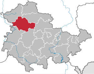
| Location of the Unstrut-Hainich district in Thuringia | |
  |
|
The Unstrut-Hainich-Kreis is a district in the northwest of Thuringia . The district was named after the river Unstrut and the Hainich ridge . In terms of spatial planning , the district belongs to the Northern Thuringia planning region and is a member of the Northern Thuringia planning community .
geography

location
The Unstrut-Hainich district is located in the northwestern part of the Thuringian Basin and its edge plates . The Unstruttal is bordered in the west and north by the limestone plates of the Hainich, the Upper Eichsfeld and the Dün . In the south-west of the Unstrut-Hainich-Kreis lies the geographical center of Germany if one proceeds from the extremes (location of the northernmost, easternmost etc. point in Germany). In the Niederdorla district of the Vogtei municipality , a stone slab was set at 51 ° 10 'north latitude and 10 ° 27' east longitude.
Neighboring districts of the Unstrut-Hainich district are the Eichsfeld district in the northwest , the Kyffhäuserkreis in the northeast, the Sömmerda district in the east, the Gotha district in the southeast and the Wartburg district in the southwest . In the west, the Unstrut-Hainich district borders the Werra-Meißner district in Hesse .
Natural structure
The northern part of the district, north of a line Obermehler-Kaisershagen-Bickenriede and the Hainich between Struth and Weberstedt, belongs to the Hainich-Dün-Hainleite natural area . The extreme west of the district touches the natural area Werrabergland-Hörselberge . The further district area is to be assigned to the Helme-Unstrut lowlands near Herbsleben and the Unstrutaue within the Central Thuringian Ackerhügelland .

_01.jpg)
natural reserve
There are 10 designated nature reserves in the district (as of January 2017).
The Hainich National Park , founded in 1997, extends over the south of the district area. It is the 13th national park in Germany. The Eichsfeld-Hainich-Werratal nature park covers the western part of the Unstrut-Hainich district. The Mühlhausen city forest is designated as a landscape protection area. In the Unstrut-Hainich district there are 33 protected landscape components, area natural monuments and natural monuments (as of December 15, 2004).
Mountains and elevations
The height of the terrain in the Unstrut-Hainich district is between 149 m on the Unstrut below Herbsleben and 517 m on the Rain near Struth. Other notable mountains and elevations are:
- Köhlerberg (504.7 m), north of Hüpstedt
- Rode (498.2 m), west of Struth
- Hohes Rode (493.0 m), at Eigenrieden
- Dörnerberg (478 m), near Diedorf
- Winterstein (467.6 m), near Heyerode
- Lohberg (468 m), southern Hainich
- Schlegelsberg (461.2 m), at Faulungen
- Haardt (451.3 m), near Kammerforst
- Forstberg (395.4 m), north of Mühlhausen
- Lehdenberg ( Heilinger Heights ) (367.6 m), near Marolterode
- Teufelsberg (358.1 m) ( Große Harth ), near Wiegleben
- Warthügel (323.6 m), near Hollenbach
- Wartberg (276.8 m), near Nägelstedt
- Roter Berg (240.2 m), near Altengottern
Waters

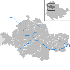
Most of the Unstrut-Hainich district drains via the Unstrut and, in the north-eastern part, via the Helbe to Saale and Elbe . The west of the district with the Haselbach and Frieda waters lies in the catchment area of the Werra and Weser . An important standing water is the Seebach dam with a storage space of 5 million cubic meters on a water surface of 1.1 km². The former moor near Niederdorla is now a lake.
history

The Unstrut-Hainich district was created on July 1, 1994 through the reorganization of the districts in Thuringia from the old district of Mühlhausen (MHL) and most of the old district of Langensalza (LSZ). Some communities in the Bad Langensalza district went to the Wartburg district and the Gotha district .
Population development
Development of the population:
|
|
|
|
|
- Data source: from 1994 Thuringian State Office for Statistics - values from December 31st
politics

District council
The 46 seats in the district council are distributed among the individual parties as follows:
| Political party | Seats | |
| CDU | 12 (−4) | |
| SPD | 9 (−3) | |
| AfD | 8 (+8) | |
| FWG-UH | 6 (+3) | |
| THE LEFT | 5 (−3) | |
| GREEN | 3 (+1) | |
| FDP | 3 (+1) | |
| NPD | 0 (−2) | |
| FWG BM | 0 (−1) |
(As of: local election on May 26, 2019 )
District Administrator
Harald Zanker ( SPD ) is the district administrator of the Unstrut-Hainich district . Councilors of the Unstrut-Hainich district are Klaus Zunke-Anhalt ( CDU ) and Jörg Klupak (SPD). The Administrative Court of Weimar declared on 15 July 2013, the re-election Zanker in 2012 invalid because there had been a material breach of the electoral law ahead of the election.
coat of arms
The coat of arms of the Unstrut-Hainich district takes into account the various historical affiliations of the former domains.
- Black eagle and the millstones: The former Free Imperial City of Mühlhausen with the associated communities is represented
- Red striped lion: Municipalities belonging to the former Landgraviate of Thuringia are symbolized.
- Mainzer Rad : Eichsfeld , which formerly belonged to the Electorate of Mainz and became Prussian in 1816, finds its expression here.
- Twelve-ended antlers: The communities formerly belonging to the Principality of Schwarzburg-Rudolstadt are represented with them.
An overview of the coats of arms of the cities and municipalities of the district can be found in the list of coats of arms in the Unstrut-Hainich district .
Economy and Infrastructure
economy
Wood and furniture production, electronics, roof tile production, worsted yarn production and the textile industry are important industries in the district in addition to handcraft and agriculture. The Unstrut-Hainich district has an agricultural area of 73,488 hectares. In February 2012, the Unstrut-Hainich district had an unemployment rate of 12.4 percent. The district was thus above the state average of 9.7 percent and above the national average.
traffic

Road traffic
The district is crossed in a north-south direction by the B 247 and in an east-west direction by the B 249 . The east of the district is also crossed by the federal highway 84 ; In Bad Langensalza, the federal highway 176 branches off from this in the direction of Straussfurt. There is a connection to the motorway network outside the district boundaries at Eisenach ( BAB 4 ) and Leinefelde-Worbis or Bleicherode ( BAB 38 ). Important state roads are the L 1042 Andisleben-Döllstedt-Tonna-Bad Langensalza and L 1016 Niedergebra-Keula-Mühlhausen-Vogtei- Mihla -Eisenach.
Transportation
The most important railway line in the district is the Gotha – Bad Langensalza – Mühlhausen – Leinefelde railway, it is significant as a direct rail connection to Erfurt and Göttingen with the possibility of connecting to ICE trains in the direction of Hanover and Hamburg . A regionally significant branch line, which partly runs in the Unstrut-Hainich district, is the Großheringen – Sömmerda – Straussfurt railway .
The lines Mühlhausen – Schlotheim , Straussfurt – Döllstädt , Mühlhausen – Heyerode – Treffurt and Leinefelde – Dingelstädt – Geismar ( Kanonenbahn ) were closed and partially dismantled .
In addition, the local public transport is ensured by regional bus lines of the regional bus company Unstrut-Hainich- und Kyffhäuserkreis , which is 100% owned by the district.
air traffic
The district owns the Obermehler-Schlotheim airfield near Mühlhausen for small private aircraft .
Communities
According to the regional plan, Mühlhausen is designated as a middle center with partial functions of an upper center. Bad Langensalza is designated as a medium-sized center .
The basic centers are Bad Tennstedt , Großengottern , Schlotheim and Südeichsfeld .
(Residents on December 31, 2019)
|
community-free municipalities
|
|
  |
Administrative communities
* Seat of an administrative community
|
For the terms "administrative community" and "fulfilling community" see administrative community and fulfilling community (Thuringia) .
Territorial changes
Communities
- Dissolution of the municipalities of Diedorf , Faulungen , Schierschwende and Wendehausen - new formation of the Katharinenberg municipality (April 21, 1995)
- Dissolution of the municipalities of Ammern , Dachrieden , Eigenrode , Horsmar , Kaisershagen and Reiser - reorganization of the municipality of Unstruttal (September 2, 1995)
- Dissolution of the communities of Kleinkeula , Menteroda , Sollstedt and Urbach - new formation of the community of Menteroda (August 1, 1996)
- Dissolution of the municipalities of Bickenriede , Dörna , Hollenbach and Zella - new formation of the municipality of Anrode (January 1, 1997)
- Dissolution of the communities of Heyerode , Katharinenberg , Hildebrandshausen and Lengenfeld unterm Stein - new formation of the rural community of Südeichsfeld (December 1, 2011)
- Dissolution of the municipalities of Langula , Niederdorla and Oberdorla - reorganization of the rural municipality Vogtei (December 31, 2012)
- Dissolution of the community of Weinbergen - incorporation into Mühlhausen / Thuringia (January 1, 2019)
- Dissolution of the communities Altengottern , Flarchheim , Großengottern , Heroldishausen , Mülverstedt and Weberstedt - reorganization of the rural community Unstrut-Hainich (January 1, 2019)
- Dissolution of the municipality of Klettstedt - incorporation into Bad Langensalza (January 1, 2019)
- Dissolution of the communities of Bothenheilingen , Issersheilingen , Kleinwelsbach , Neunheilingen , Obermehler and the city of Schlotheim - reorganization of the city and rural community of Nottertal-Heilinger Höhen (December 31, 2019)
Administrative communities and fulfilling communities
- Expansion of the administrative community Hildebrandshausen / Lengenfeld unterm Stein to include the municipality of Rodeberg (September 30, 1994)
- The town of Schlotheim becomes a fulfilling community for Bothenheilingen , Issersheilingen , Kleinwelsbach , Körner , Marolterode and Neunheilingen (March 9, 1995)
- Herbsleben parish becomes a fulfilling parish for Großvargula (March 31, 1995)
- Dissolution of the administrative community Diedorf - formation of the Katharinenberg community (April 20, 1995)
- Dissolution of the administrative community Unstrut-Luhne - formation of the Unstruttal community from the member communities (September 1, 1995)
- Dissolution of the administrative community Menteroda - formation of the community Menteroda from the member communities, with the exception of the community Obermehler ; the city of Schlotheim becomes the fulfilling municipality (August 1, 1996)
- Dissolution of the administrative community Landgraben-West - formation of the community Anrode from the member communities (January 1, 1997)
- Expansion of the Unstrut-Hainich administrative community to include the community of Schönstedt (January 1, 1997)
- The town of Schlotheim is no longer a fulfilling municipality for Bothenheilingen , Issersheilingen , Kleinwelsbach , Körner , Marolterode , Neunheilingen and Obermehler - formation of the Schlotheim administrative community (March 12, 1999)
- Dissolution of the administrative community Hildebrandshausen / Lengenfeld unterm Stein - formation of the rural community Südeichsfeld from the member communities, with the exception of the community Rodeberg ; Südeichsfeld becomes the fulfilling municipality (December 1st, 2011)
- Dissolution of the administrative community Vogtei - formation of the rural community Vogtei from the member communities, with the exception of the communities Kammerforst and Oppershausen ; Bailiwick becomes the fulfilling municipality (December 31, 2012)
- Dissolution of the administrative community Unstrut-Hainich - formation of the rural community Unstrut-Hainich from the member communities, with the exception of the community Schönstedt ; Unstrut-Hainich becomes the fulfilling municipality (January 1, 2019)
- Outsourcing of the municipality of Klettstedt from the Bad Tennstedt administrative community (January 1, 2019)
- Dissolution of the Schlotheim administrative community - formation of the town and rural community of Nottertal-Heilinger Höhen , with the exception of the communities of Körner and Marolterode ; Nottertal-Heilinger Höhen becomes the fulfilling municipality (December 31, 2019)
License Plate
On July 1, 1994, the district was assigned the vehicle distinguishing signs LSZ (Bad Langensalza) and MHL (Mühlhausen / Thuringia). These were replaced on February 1st, 1995 by the new distinctive sign UH . The abbreviations LSZ and MHL have been available again since November 24, 2012 .
literature
- R. Reuther, R. Weise: The Unstrut-Hainich district with its landscapes, natural beauties and protected areas. Nature Conservation Information Center North Thuringia eV, Mühlhausen 1996.
- R. Weise, U. Fickel, R. Halle, W. Hochstrate, E. Lehnert, R. Faupel and R. Kaiser (2007): Natural monuments in the Unstrut-Hainich district. Nature Conservation Information Center North Thuringia eV, Mühlhausen
Web links
Individual evidence
- ↑ a b Population of the communities from the Thuringian State Office for Statistics ( help on this ).
- ↑ mittpunkt-deutschlands.de
- ↑ a b tlug-jena.de accessed on January 15, 2013.
- ↑ Map services of the Federal Agency for Nature Conservation ( information )
- ↑ District election in the Unstrut-Hainich district 2019 In: wahlen.thueringen.de .
- ↑ mdr.de ( Memento from July 18, 2013 in the Internet Archive )
- ↑ Regional plan North Thuringia from June 27, 2012 , accessed on October 16, 2016
Cities : Eisenach | Erfurt | Gera | Jena | Suhl | Weimar
Districts : Altenburger Land | Eichsfeld | Gotha | Greiz | Hildburghausen | Ilm district | Kyffhäuserkreis | Nordhausen | Saale-Holzland district | Saale-Orla district | Saalfeld-Rudolstadt | Schmalkalden-Meiningen | Sömmerda | Sonneberg | Unstrut-Hainich Circle | Wartburg district | Weimar Country