
Hornsummer
| coat of arms | Germany map | |
|---|---|---|

|
Coordinates: 51 ° 13 ' N , 10 ° 49' E |
|
| Basic data | ||
| State : | Thuringia | |
| County : | Unstrut-Hainich district | |
| Management Community : | Bad Tennstedt | |
| Height : | 290 m above sea level NHN | |
| Area : | 4.32 km 2 | |
| Residents: | 162 (Dec. 31, 2019) | |
| Population density : | 38 inhabitants per km 2 | |
| Postal code : | 99955 | |
| Area code : | 036041 | |
| License plate : | UH, LSZ, MHL | |
| Community key : | 16 0 64 027 | |
| Address of the municipal administration: |
Platz der Einheit 47a 99955 Hornsommern |
|
| Website : | ||
| Mayor : | Heinz Schröter (Free Voters) | |
| Location of the municipality of Hornsömmern in the Unstrut-Hainich district | ||
  |
||

Hornsömmern is a municipality in the Unstrut-Hainich district in Thuringia . It belongs to the Bad Tennstedt administrative community .
geography
The village is in the immediate vicinity of the mid-summer in the southwest on the southeast slope of a 334 m high elevation. In the local area, a small stream rises, which after about 500 m unites with a trickle that comes from mid-summer to the Rechenbach . This flows to Kutzleben and belongs to the catchment area of the Unstrut . The border with the Kyffhäuserkreis runs a few 100 m north of the village . The next neighboring town "across the border" is Rohnstedt . The area around the village is hilly and used for agriculture. There are trees on the edges of the road and accompanied by the two streams. The Waidmühlstein on the Anger and the street name Waidmühlengasse allow the assumption that the brook once operated a mill.
history
A stone circle six meters in diameter was found in front of a Neolithic large stone grave. In addition, a stone slab and ceramic fragments were detected. This forecourt of the collective grave is interpreted as a place of worship and sacrifice. The finds come from the Bernburg culture .
Hornsömmern belonged to the Electoral Saxon Office of Langensalza until 1815 and, after its cession to Prussia, from 1816 to 1944 to the district of Langensalza in the province of Saxony .
politics
Municipal council
The council of the municipality of Hornsömmern consists of 6 council women and councilors who belong to a free voter group. (As of: local election on May 26, 2019 )
mayor
The honorary mayor Heinz Schröter was re-elected on June 5, 2016.
Culture and sights
- The village green with the community tavern and the Waidmühlstein
- The Evangelical Church of St. Maria is essentially a Romanesque hall church . It contains a closed choir with three lancet windows from the middle of the 13th century. In the south, one is sacristy timbered attachment for the belfry, north of the cultivation of a wide arch to the nave opened Patronatsloge . The hall was renovated in the 19th century with a romanization. The exterior was restored in 1992 and 1993. The barrel vaulted hall has a three-sided gallery and a sacrament niche in the choir. In the pulpit altar from the 18th century, the figures of Moses, John the Baptist and Christ are relocated. The groin-vaulted sacristy shows remains of colored ornamental paintings from the 16th century.
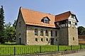
Village church of St. Maria from the southwest

Village church of St. Maria from the northeast

Gate of the church to the west

At the Anger

Community gifts
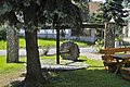
Waidmühl monument


Individual evidence
- ^ Population of the municipalities from the Thuringian State Office for Statistics ( help on this ).
- ↑ Michael Köhler: Pagan sanctuaries. Pre-Christian places of worship and suspected cult sites in Thuringia. Jenzig-Verlag Köhler, Jena 2007, ISBN 978-3-910141-85-8 , pp. 182-183, and Hans-Jürgen Beier : Megalithic buildings as places of worship. In: Hans-Jürgen Beier: The megalithic, submegalithic and pseudomegalithic buildings as well as the menhirs between the Baltic Sea and the Thuringian Forest (= contributions to the prehistory and early history of Central Europe. 1, ZDB -ID 916540-x ). Printed as a manuscript. Beier & Beran, Wilkau-Haßlau 1991, p. 197, (at the same time: Halle-Wittenberg, University, habilitation paper, 1991: The megalithic, submegalithic and pseudomegalithic buildings as well as the menhirs in the five new East German federal states (formerly GDR) - one Inventory. ).
- ↑ City council election 2019 in Thuringia. Thuringian State Office for Statistics, accessed on July 6, 2019 .
- ↑ Mayoral elections in Thuringia. Thuringian State Office for Statistics, accessed on July 6, 2019 .
- ↑ Stephanie Eißing and others: Thuringia (= Handbook of German Art Monuments . ). Revision. 2nd, revised and supplemented edition. Deutscher Kunstverlag, Munich 2003, ISBN 3-422-03095-6 , p. 625.
Web links
Anrode | Bad Langensalza | Bad Tennstedt | Ballhausen | Blankenburg | Bruchstedt | Dünwald | Greater Vargula | House summer | Autumn life | Hornsummer | Kammerforst | Kirchheilingen | Grains | Kutzleben | Marolterode | Menteroda | Midsummer | Mühlhausen / Thuringia | Nottertal-Heilinger Heights | Oppershausen | Rodeberg | Schönstedt | Südeichsfeld | Sundhausen | Dead life | Unstrut-Hainich | Unstruttal | Primeval life | Bailiwick